Home > Europe > Sweden > Maps
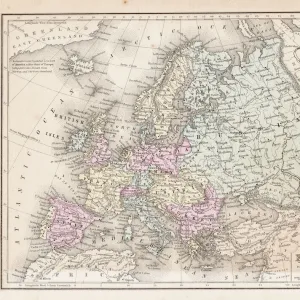
Dickson'in sataman. Kartta. G. Boven tekema, 1878. Creator: G. Boven

![]()
Wall Art and Photo Gifts from Heritage Images
Dickson'in sataman. Kartta. G. Boven tekema, 1878. Creator: G. Boven
Dickson'in sataman. Kartta. G. Boven tekema, 1878. Dikson, o-v. Karta puteshestvii?a? Nordenshel'da na karable "Vega" u beregov Diksona v 1878 godu. Na karte imeetsi?a? roza vetrov, 3 dopol'nitel'nykh kart: 1.Kap Bolvan Vai?gash-Saaressa; 2. Lenan Matka Malygin Salmessa. A. Khovgaardin tekema; 3. Kap Cheli?u?skinin Kartta. I?U?. Boven Tekema
Heritage Images features heritage image collections
Media ID 35127495
© Heritage Art/Heritage Images
1870s Cartographic Cartography Federation Island Krasnoyarsk Krai Russia Map Making Mapmaking Russian State Library Siberia Meeting Of Frontiers
FEATURES IN THESE COLLECTIONS
> Europe
> Russia
> Krasnoyarsk
> Europe
> Sweden
> Related Images
> Maps and Charts
> Early Maps
EDITORS COMMENTS
This map print, titled "Dickson's Chart. G. Boven's Map, 1878," offers a glimpse into the rich cartographic history of the late 19th century. Created by G. Boven, this map depicts the northern coast of Russia, specifically the regions of Dikson and Krasnoyarsk Krai, as well as parts of Sweden and Siberia. The map is an intricate representation of the meeting of frontiers between these nations, with detailed labeling of various capes, bays, and waterways. The map's vibrant color palette adds to its allure, with a rosy hue indicating the prevailing winds. Three additional maps are included as inserts, each focusing on specific areas: the cape of Bolvan Vai?gash-Saaressa, Lenan Matka Malygin Salmessa, and the cape of Cheli?u?skinin. This map holds significant historical value, as it was created during a period of intense exploration and cartographic advancement. It is a testament to the curiosity and ambition of the scientific community during the 1870s, a time when the boundaries of geographic knowledge were being pushed ever further. The map is now part of the prestigious collections of the Library of Congress, a testament to its importance in the realm of cartography and heritage art. Its intricate details and historical significance make it an invaluable resource for scholars, historians, and anyone with an interest in the history of geography and exploration.
MADE IN THE USA
Safe Shipping with 30 Day Money Back Guarantee
FREE PERSONALISATION*
We are proud to offer a range of customisation features including Personalised Captions, Color Filters and Picture Zoom Tools
SECURE PAYMENTS
We happily accept a wide range of payment options so you can pay for the things you need in the way that is most convenient for you
* Options may vary by product and licensing agreement. Zoomed Pictures can be adjusted in the Cart.