Fraud Blocker Skip to main content

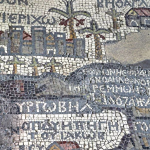
MADABA MAP, 6TH CENTURY. The Madaba Mosaic Map, the oldest known map of the city of Jerusalem

MADABA MAP, 6TH CENTURY. The Madaba Mosaic Map, the oldest known map of the city of Jerusalem
Sold 2
In Stock
We accept all major payment options so you can pay for the things you need in the way that is most convenient for you

Granger Photo Prints and Wall Art

MADABA MAP, 6TH CENTURY. The Madaba Mosaic Map, the oldest known map of the city of Jerusalem

MADABA MAP, 6TH CENTURY. The Madaba Mosaic Map, the oldest known map of the city of Jerusalem, located in the Byzantine Church of Saint George at Madaba, Jordan, 6th century A.D. Granger holds millions of images spanning more than 25,000 years of world history, from before the Stone Age to the dawn of the Space Age.

Media ID 6616585

6th Century Artifact Byzantine Church Holy Land Jerusalem Jordan Mosaic Saint Madaba

SECURE PAYMENTS
We accept all major payment options so you can pay for the things you need in the way that is most convenient for you

Made in USA
Safe Shipping, Easy Returns

FREE PERSONALISATION
We are proud to offer a range of customisation including Cropping, Captions, and Filters. Zoom Cropping can be adjusted in the basket


EDITORS COMMENTS

This print showcases the remarkable "Madaba Map" a priceless artifact from the 6th century. Known as the oldest known map of Jerusalem, this mosaic masterpiece is located within the Byzantine Church of Saint George in Madaba, Jordan. The intricately detailed mosaic depicts various landmarks and structures that once adorned the holy city of Jerusalem during ancient times. Every tile meticulously placed by skilled hands, this awe-inspiring work of art offers a glimpse into history like no other. As you gaze upon this image, you can't help but be transported back to an era long gone. The vibrant colors and intricate patterns tell stories of a bustling city filled with life and religious significance. The Madaba Map serves not only as a visual representation but also as a testament to human ingenuity and dedication. It stands as a reminder that even centuries ago, people were capable of creating astonishing works that continue to captivate us today. Whether you are an art enthusiast or simply fascinated by history, this print is sure to spark curiosity and ignite your imagination. Let it transport you to another time and place—a window into the past where ancient civilizations thrived and left their mark on our world forever.


Framed Prints of MADABA MAP, 6TH CENTURY. The Madaba Mosaic Map

Discover the rich history of the Holy Land with our exquisite Framed Prints featuring the ancient Madaba Map. Dated back to the 6th century, this rare and intricately detailed mosaic map is a testament to the Byzantine era's artistic and cartographic achievements. Originally discovered in the Church of Saint George at Madaba, Jordan, this precious artifact showcases Jerusalem and its surrounding areas with remarkable accuracy. Bring a piece of history into your home or office with our high-quality Framed Prints, expertly crafted to preserve the authentic beauty and intricacy of The Granger Collection's Madaba Map from Granger Art on Demand.


Photo Prints of MADABA MAP, 6TH CENTURY. The Madaba Mosaic Map

Step back in time with our stunning Madaba Mosaic Print from The Granger Collection. This ancient 6th-century mosaic map, discovered in the Byzantine Church of Saint George at Madaba, Jordan, is the oldest known representation of the city of Jerusalem. Bring the rich history and intricate details of this remarkable artifact into your home or office. Each print is produced using high-quality materials to ensure vibrant colors and sharp details, making it a beautiful and educational addition to any space. Experience the past like never before with our Madaba Mosaic Print.


Poster Prints of MADABA MAP, 6TH CENTURY. The Madaba Mosaic Map

"Discover history with our stunning Madaba Map Poster Print, showcasing the oldest known representation of the city of Jerusalem. Dating back to the 6th century, this intricate mosaic map was discovered in the Byzantine Church of Saint George in Madaba, Jordan. Bring the rich history of this ancient city into your home or office with our high-quality poster print from The Granger Collection. This captivating piece of art is not only a beautiful addition to any space but also a conversation starter, transporting you back in time. Order your Madaba Map Poster Print today and step into the past."


Jigsaw Puzzles of MADABA MAP, 6TH CENTURY. The Madaba Mosaic Map

Discover the rich history of the ancient world with our captivating jigsaw puzzle from the Media Storehouse collection. This intriguing puzzle features the Madaba Map, the oldest known representation of the city of Jerusalem. Dating back to the 6th century, this masterpiece was discovered in the Byzantine Church of Saint George at Madaba, Jordan. Bring the intricate details of this historic mosaic map to life as you piece together this jigsaw puzzle. A perfect addition to any home or office, this puzzle is not only a fun and engaging activity but also an educational experience that will transport you back in time.

diamond
Made With High Grade Materials
thumb_up
Professional Quality Finish
package_2
Carefully Packed To Aid Safe Arrival

You May Also Like


Jerusalem (6th c. )Jerusalem (6th c. )
Add to Basket
Liberty Triumphant, or the Downfall of Oppression, 1773 (engraving)Liberty Triumphant, or the Downfall of Oppression, 1773 (engraving)
Add to Basket
Mosaic Floor in Jerash, Jerash Governorate, JordanMosaic Floor in Jerash, Jerash Governorate, Jordan
Add to Basket
Entry to Jerusalem church, 1794, Totma, Vologda region, RussiaEntry to Jerusalem church, 1794, Totma, Vologda region, Russia
Add to Basket
Crouching LynX Date: 1880Crouching LynX Date: 1880
Add to Basket
Hampden Park in 1933Hampden Park in 1933
Add to Basket
Caravan of horses climbing over the Singge La mountain pass at an altitude of 5010mCaravan of horses climbing over the Singge La mountain pass at an altitude of 5010m
Add to Basket
0950049496. jpg0950049496. jpg
Add to Basket
Georgia, Batumi. St. Nicholas Church exteriorGeorgia, Batumi. St. Nicholas Church exterior
Add to Basket
Farnese Hercules, c. 1550 / 1599. Creator: UnknownFarnese Hercules, c. 1550 / 1599. Creator: Unknown
Add to Basket
The Battle between Alexander and Porus (oil on canvas)The Battle between Alexander and Porus (oil on canvas)
Add to Basket
A Directory curule armchair, c. 1795 (ebonised & gilded wood with leopard print upholsteryA Directory curule armchair, c. 1795 (ebonised & gilded wood with leopard print upholstery
Add to Basket

Gallery Wall Inspiration

MAP: PHILIPPINES, 1905. Map of the Philippine Islands printed in the United States in 1905
MAP: SCOTLAND. Line engraving, 19th century
MAP: BRITISH EMPIRE, 1886. Map, 1886, of the British Empire by Walter Crane
MAP OF MACEDONIAN EMPIRE. Map of the Macedonian Empire following the conquests of Alexander the Great, 4th
MAP: JAMAICA, 1893. British map of Jamaica by Colin Liddell, published 1893
MAP OF ITALY, c1585. By Ignazio Danti from Sistine Chapel Gallery of Maps
MAP OF FRANCE, c1900. With inset detail of Paris and surrounding area
MAP: HAWAII, 1905. Map of the Hawaiian Islands printed in the United States in 1905
MANSA MUSA (1312-1337). King of Mali. Mansa Musa seated on his throne
MAP: CUBA, 1900. Map of Cuba printed in the United States, c1900
MAP: IRELAND, 1851. An engraved map of Ireland, 1851
PLYMOUTH, MA, MAP 1605. Samuel de Champlains map of Port St. Louis, later settled by the English as Plymouth, Massachusetts, drawn during an expedetion of 1605
STRABO WORLD MAP, c20 A. D. According to the writings of the Greek geographer Strabo
VESPUCCIs WORLD MAP, 1526. Juan Vespuccis world map, 1526
VENICE: MAP, 17TH CENTURY. Map of Venice by Guiseppe Heintz, 17th century
WORLD MAP. Pre-Christian era, c450 B. C. according to the writings of Herodotus
MADABA MAP, 6TH CENTURY. The Madaba Mosaic Map, the oldest known map of the city of Jerusalem
WORLD MAP, 11th CENTURY. The Cottonian or Anglo-Saxon World Map
CONSTELLATION MAP. An Indian Sanskrit star map, 1840, ordered as a manuscript horoscope for Prince
MAP: UNITED STATES, 1905. Map of the continental United States (excluding Alaska), 1905
CARIBBEAN MAP. A map of the Caribbean islands: woodcut, French, c. 1688
AFRICA: MAP. Birds eye view of the Sudan and surrounding countries
CANTINO WORLD MAP, 1502. Western half of the Cantino map of the world
ICELAND: MAP, 1595. Map of Iceland from a 1595 edition of Abraham Ortelius atlas Theatrum
TENOCHTITLAN (MEXICO CITY) at the time of the Spanish Conquest: colored woodcut, 1556
ST. BRENDAN: MASS. St. Brendan and his monks celebrate Mass on the back of a whale


© Copyright Media Storehouse, All Rights Reserved 2003 - 2024
Facebook     Pinterest     100% Payment Secure     Reviews IO