Fraud Blocker Skip to main content

Urbanisation Collection (page 4)

"Captivating Urbanisation: A Global Perspective" Sheffield, UK - An aerial image captures the dynamic growth of this industrial city

Background imageUrbanisation Collection: Waterloo Station, London, aerial view C017 / 0661

Waterloo Station, London, aerial view C017 / 0661
Waterloo Station, London, aerial photograph. Waterloo Station terminal and lines can be seen centre middle towards bottom middle of the image

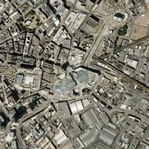
Background imageUrbanisation Collection: Birmingham city centre, aerial photograph C016 / 9924

Birmingham city centre, aerial photograph C016 / 9924
Birmingham city centre, aerial photograph. At centre, middle is the Bullring Shopping Centre. Photographed in 2004

Background imageUrbanisation Collection: Isle of Dogs, aerial photograph C016 / 9934

Isle of Dogs, aerial photograph C016 / 9934
Isle of Dogs, London, UK, aerial photograph. The Isle of Dogs in east London includes extensive office buildings around the Canary Wharf Tower (top)

Background imageUrbanisation Collection: Darkhan city, Mongolia

Darkhan city, Mongolia
Darkhan city. View of Darkhan, a city built near the Russian border in northern Mongolia. The city was created as an industrial centre

Background imageUrbanisation Collection: Plant growing through asphalt C015 / 5187

Plant growing through asphalt C015 / 5187
Plant growing through asphalt

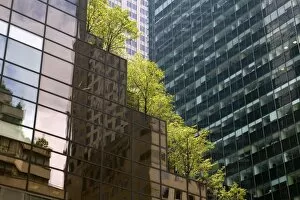
Background imageUrbanisation Collection: Urban landscaping C015 / 5184

Urban landscaping C015 / 5184
Urban landscaping. Trees growing on a skyscraper

Background imageUrbanisation Collection: Urban landscaping C015 / 5185

Urban landscaping C015 / 5185
Urban landscaping. Trees growing on a skyscraper

Background imageUrbanisation Collection: Paper mill

Paper mill, Northfleet, Kent

Background imageUrbanisation Collection: Santiago, Chile, at dawn C013 / 7505

Santiago, Chile, at dawn C013 / 7505
Santiago at dawn. View over smog and a smoking power station in Santiago, Chile, at dawn. Santiago is the capital city of Chile

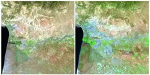
Background imageUrbanisation Collection: Morocco 1985-2011 C013 / 7147

Morocco 1985-2011 C013 / 7147
Morocco 1985-2011. Landsat satellite photographs of cities near the Atlantic coast of Morocco. The right hand image, taken in 2011

Background imageUrbanisation Collection: Binhai, China, 1992-2012 C013 / 7146

Binhai, China, 1992-2012 C013 / 7146
Binhai, China, 1992-2012. Landsat satellite photograph of Binhai, China. This city is located on the coast of the Bohai Sea Region southeast of Beijing in China

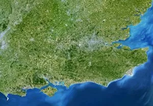
Background imageUrbanisation Collection: South-East England

South-East England, satellite image. North is at top. This view is about 280 kilometres across, stretching from Bristol (grey area, centre left) to the eastern coast of Kent (far right)

Background imageUrbanisation Collection: Liverpool, UK, aerial image

Liverpool, UK, aerial image
Liverpool, UK, aerial photograph. The city of Liverpool occupies the north bank of the Mersey Estuary. Black and white regions are areas of water where no photographs were taken

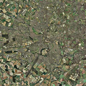
Background imageUrbanisation Collection: Coventry, UK, aerial image

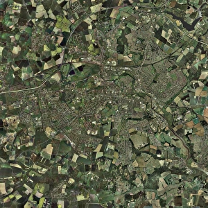
Coventry, UK, aerial image

Background imageUrbanisation Collection: Bradford, UK, aerial image

Bradford, UK, aerial image

Background imageUrbanisation Collection: Cardiff, aerial photograph

Cardiff, aerial photograph
Cardiff, Wales, UK, aerial photograph. Cardiff, a port on the Bristol channel, is the largest city in Wales and its capital. It has a population of 305, 000 (2001)

Background imageUrbanisation Collection: London, aerial image

London, aerial image
London, UK. Aerial photograph of London, the capital city of the UK. The River Thames is flowing across centre

Background imageUrbanisation Collection: Edinburgh, Scotland, UK, satellite image

Edinburgh, Scotland, UK, satellite image. North is at top, water is blue, urban areas are grey, vegetation is green and agricultural areas are brown

Background imageUrbanisation Collection: London, aerial photograph

London, aerial photograph
London, UK. Aerial photograph of London, the capital city of England and the UK. The River Thames is flowing across centre

Background imageUrbanisation Collection: Skyscrapers, Dubai

Skyscrapers, Dubai, United Arab Emirates, Arabian Peninsula, Asia

Background imageUrbanisation Collection: Central Park, New York, USA

Central Park, New York, USA
Central Park. Aerial photograph of Central Park in Manhatten, New York, USA

Background imageUrbanisation Collection: Digital city, computer artwork

Digital city, computer artwork
Digital city. Composite image of a city skyline superimposed with alphanumeric digits

Background imageUrbanisation Collection: Greater London, satellite image

Greater London, satellite image. North is at top. Vegetation is green, water is blue and urbanised areas are grey and pink. London is the most populous city in the European Union

Background imageUrbanisation Collection: Colchester, Essex, UK, aerial photograph

Colchester, Essex, UK, aerial photograph. North is at top. Colchester is said to be the oldest recorded town in Britain, as it was mentioned as Camulodunum by the Roman writer Pliny the Elder in

Background imageUrbanisation Collection: Redditch, UK, aerial image

Redditch, UK, aerial image. The prominent road running from top to bottom down right is the A441, linking Birmingham to the north (top) with Studley to the south

Background imageUrbanisation Collection: Shanghai and the Yangtze, 1989

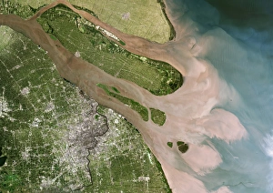
Shanghai and the Yangtze, 1989. Image to of two. Shanghai, visible as a grey conurbation towards the bottom left, is one of the largest cities in the world

Background imageUrbanisation Collection: Malmo, satellite image

Malmo, satellite image. Water is blue, forest is dark green, agricultural areas are green and brown and urbanised areas are pink

Background imageUrbanisation Collection: Auckland, New Zealand, satellite image

Auckland, New Zealand, satellite image. North is at top, water is blue, shallow coastal areas are light blue, urban areas are grey and vegetation areas are green

Background imageUrbanisation Collection: Derby, UK, aerial image

Derby, UK, aerial image. The river Derwent flows through the city down right

Background imageUrbanisation Collection: Urban decay

Urban decay. Damaged vehicle in front of an abandoned block of flats in an inner- city area

Background imageUrbanisation Collection: Las Vegas, satellite image

Las Vegas, satellite image. North is at top. Vegetation is green, desert is brown, bare soil is white and water is blue. The lake at far right is Lake Mead, the largest man-made lake in the world

Background imageUrbanisation Collection: Charleston, South Carolina, USA

Charleston, South Carolina, USA, satellite image. North is at top, water is blue, shallow coastal areas are light blue, urban areas are grey and vegetation is green

Background imageUrbanisation Collection: Gateshead, UK, aerial image

Gateshead, UK, aerial image. This town is on the south bank of the river Tyne (top left). On the north bank is the city of Newcastle

Background imageUrbanisation Collection: Ancona, Italy

Ancona, Italy, aerial photograph. Ancona is a city and a seaport situated on the Adriatic Sea

Background imageUrbanisation Collection: Plymouth, UK, aerial image

Plymouth, UK, aerial image. The city lies on Plymouth Sound (lower frame), one of the largest natural harbours in the world

Background imageUrbanisation Collection: Kingston upon Hull, UK

Kingston upon Hull, UK, aerial image. This city, on the north bank of the Humber estuary (lower right) is commonly known as Hull

Background imageUrbanisation Collection: Helsinki, satellite image

Helsinki, satellite image. North is at top. Vegetation is green, water is blue and urbanised areas are pink and grey. Helsinki is the capital of Finland

Background imageUrbanisation Collection: Venice, satellite image

Venice, satellite image
Venice and surroundings, satellite image. North is at top. Water is blue, vegetation is green and urbanised areas are orange. The black areas are submerged land

Background imageUrbanisation Collection: Crawley, UK, aerial image

Crawley, UK, aerial image
Crawley, UK, aerial photograph. Crawley is a new town in West Sussex. To its north (top) is London Gatwick Airport, the busiest single-runway airport in the world

Background imageUrbanisation Collection: View of London, UK

View of London, UK at sunset from inside a capsule on the British Airways London Eye (Millenium Wheel). The London Eye opened in 1999 and it is the largest observation wheel in the world

Background imageUrbanisation Collection: Shanghai and the Yangtze, 2001

Shanghai and the Yangtze, 2001. Image one of one. Shanghai, visible as a purple grey conurbation towards bottom left, is one of the largest cities in the world

Background imageUrbanisation Collection: Rotterdam, satellite image

Rotterdam, satellite image. North is at top. Vegetation is green, water is blue and urban areas are pale blue and pink. Rotterdam is the second largest city in the Netherlands

Background imageUrbanisation Collection: Manchester, UK, aerial image

Manchester, UK, aerial image

Background imageUrbanisation Collection: Cairo, satellite image

Cairo, satellite image. North is at top. Vegetation is green, bare and barren ground is cream to white and urbanised areas are grey. Cairo (upper right) is the capital city of Egypt

Background imageUrbanisation Collection: Newcastle upon Tyne, UK, aerial image

Newcastle upon Tyne, UK, aerial image
Newcastle upon Tyne, UK, satellite image. Several bridges are seen crossing the river Tyne, linking Newcastle on the north bank (top) with Gateshead on the south bank

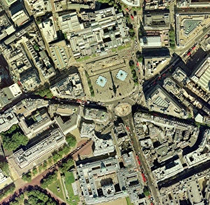
Background imageUrbanisation Collection: Trafalgar square, aerial photograph

Trafalgar square, aerial photograph
Trafalgar Square, aerial photograph. Trafalgar Square was designed by Sir Charles Barry to commemorate the Battle of Trafalgar (1805), and building was completed in 1845

Background imageUrbanisation Collection: Southampton, UK, aerial image

Southampton, UK, aerial image. This is a major port city on the south coast. At bottom left is part of the river Test, which flows into Southampton Water

Background imageUrbanisation Collection: Coventry, UK

Coventry, UK, aerial photograph. Coventry is a city in the West Midlands of England. It has a population of around 300, 000


All Professionally Made to Order for Quick Shipping

"Captivating Urbanisation: A Global Perspective" Sheffield, UK - An aerial image captures the dynamic growth of this industrial city, where urbanisation has transformed its landscape into a bustling metropolis. Vancouver, Canada - Behold the stunning view of this coastal gem; urbanisation harmoniously blends with nature as skyscrapers rise against a backdrop of majestic mountains and sparkling waters. Europe at night - Witness the mesmerizing satellite image showcasing Europe's vibrant cities illuminated by countless lights, symbolizing the continent's rapid urbanisation and thriving economies. Hong Kong at dawn - As day breaks over this iconic skyline, witness how urbanisation has shaped Hong Kong into an architectural marvel that seamlessly merges tradition with modernity. Swanley, Kent, England - From above, observe the main road that runs through this charming town in Kent; a testament to how even smaller communities contribute to the global phenomenon of urbanisation. India at night - This satellite image reveals India's transformation under the cloak of darkness; sprawling cities light up like constellations as urbanisation propels economic progress across diverse landscapes. Modica Italy's old town view – Step back in time amidst narrow cobblestone streets and ancient architecture; while surrounded by history, Modica showcases pockets untouched by modern-day urbanisation. South America at night – Gaze upon a breathtaking satellite image capturing South America’s nocturnal beauty; twinkling lights signify not only major cities but also emerging hubs embracing rapid urban development. London, UK – A bird’s-eye-view unveils London’s grandeur from above; centuries-old landmarks blend harmoniously with contemporary skyscrapers epitomising successful integration within an ever-changing world driven by relentless urbanisation Reading & Southampton (UK)– These two contrasting towns showcase different facets of British suburban life amid ongoing waves of urban expansion—a tale told through their unique architectural landscapes.