Fraud Blocker Skip to main content

Maps Collection (page 8)

Maps have always been a fascinating window into the past, allowing us to explore and understand the world as it once was

Background imageMaps Collection: Whittaker / Scorpio / Libra

Whittaker / Scorpio / Libra
Including the signs of Scorpio and Libra

Background imageMaps Collection: Whittaker / Aquarius / Capri

Whittaker / Aquarius / Capri
Including the signs of Aquarius and Capricorn

Background imageMaps Collection: Map / Asia / East Indies

Map / Asia / East Indies
India and its neighbours : note that Burma is named India beyond the Ganges

Background imageMaps Collection: Map of Europe according to the Peace Treaties 1918 - 1924. From The Evolution of Modern Europe

Map of Europe according to the Peace Treaties 1918 - 1924. From The Evolution of Modern Europe, 1453 - 1932, published 1933

Background imageMaps Collection: Map of Europe in 1815. From The Evolution of Modern Europe, 1453 - 1932, published 1933

Map of Europe in 1815. From The Evolution of Modern Europe, 1453 - 1932, published 1933

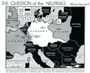
Background imageMaps Collection: Map of Europe showing WW2 alliances, September 1939

Map of Europe showing WW2 alliances, September 1939
A map of Europe, colour-coded to represent the different alliances between nations shortly after the outbreak of war, September 1939

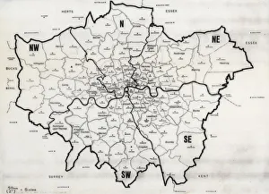
Background imageMaps Collection: Map of the Greater London area

Map of the Greater London area with council areas marked. Date: mid-20th century

Background imageMaps Collection: Astronomical Diagrams (colour litho)

Astronomical Diagrams (colour litho)
8658793 Astronomical Diagrams (colour litho) by English School, (20th century); Private Collection; (add.info.: Astronomical Diagrams)

Background imageMaps Collection: 'Scale' in Maps (colour litho)

"Scale" in Maps (colour litho)
8658789 "Scale" in Maps (colour litho) by English School, (20th century); Private Collection; (add.info.: "Scale" in Maps)

Background imageMaps Collection: Plan of the taking of Barasound in Finland, 1789 (ink and watercolour)

Plan of the taking of Barasound in Finland, 1789 (ink and watercolour)
7339497 Plan of the taking of Barasound in Finland, 1789 (ink and watercolour) by Unknown artist, (18th century); 39x52 cm; National Maritime Museum, London

Background imageMaps Collection: Sketch of discoveries on the northern coast of America by Captain McClintock RN in search of Sir

Sketch of discoveries on the northern coast of America by Captain McClintock RN in search of Sir John Franklin
7339496 Sketch of discoveries on the northern coast of America by Captain McClintock RN in search of Sir John Franklin, c.1859 (coloured engraving) by Wyld

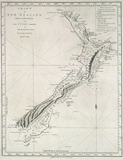
Background imageMaps Collection: Chart of New Zealand, explored in 1769 and 1770 by Lieutenant J.Cook

Chart of New Zealand, explored in 1769 and 1770 by Lieutenant J.Cook, Commander of His Majesty's Bark Endeavour
7339484 Chart of New Zealand, explored in 1769 and 1770 by Lieutenant J.Cook, Commander of His Majesty's Bark Endeavour, 1772 (single sheet engraving) by Cook

Background imageMaps Collection: Map of central and northern Europe, 1493 (coloured woodcut)

Map of central and northern Europe, 1493 (coloured woodcut)
7339468 Map of central and northern Europe, 1493 (coloured woodcut) by Munzer, Hieronymus (1437/47-1508); 41x58 cm; National Maritime Museum, London

A new map of Asia', 1673 (paper)
7339466 A new map of Asia', 1673 (paper) by Ogilby, John (1600-1676); 45x60 cm; National Maritime Museum, London, UK; (add.info.: Creator)

Background imageMaps Collection: Sketch of part of the Island of Corsica, 1794 (pen, ink, wash)

Sketch of part of the Island of Corsica, 1794 (pen, ink, wash)
7339462 Sketch of part of the Island of Corsica, 1794 (pen, ink, wash) by Dundas, H. (18th century); 59x47 cm; National Maritime Museum, London, UK; (add.info.: Creator: H. Dundas Scale: 1:45 000)

Background imageMaps Collection: A correct chart of the city and harbour of Dublin, Irleand, 1730 (coloured engraving)

A correct chart of the city and harbour of Dublin, Irleand, 1730 (coloured engraving)
7339461 A correct chart of the city and harbour of Dublin, Irleand, 1730 (coloured engraving) by Price, Charles (1679?-1733); 47x58 cm; National Maritime Museum, London

Background imageMaps Collection: Chart of the Moluccas, Indonesia, 1640 (coloured engraving)

Chart of the Moluccas, Indonesia, 1640 (coloured engraving)
7339459 Chart of the Moluccas, Indonesia, 1640 (coloured engraving) by Blaeu, Willem (1571-1638); 55x65 cm; National Maritime Museum, London

Background imageMaps Collection: A chart of Delaware Bay and river, containing a full and exact description of the shores, creeks

A chart of Delaware Bay and river, containing a full and exact description of the shores, creeks, harbours, soundings
7339439 A chart of Delaware Bay and river, containing a full and exact description of the shores, creeks, harbours, soundings, shoals, sands and bearings of the most considerable land marks

Background imageMaps Collection: A table containing details of the main maritime ports that are represented in the map of

A table containing details of the main maritime ports that are represented in the map of the English Channel
7339430 A table containing details of the main maritime ports that are represented in the map of the English Channel, c.1780 (paper, linen) by Unknown artist

Background imageMaps Collection: A general chart on Mercators projection to show the track of the 'Lion'

A general chart on Mercators projection to show the track of the 'Lion'
7339422 A general chart on Mercators projection to show the track of the 'Lion' and 'Hindostan' from England to the Gulph of Pekin in China and their return back to England

Background imageMaps Collection: Navigation through the Straits of Sunda to Batavia, 1803 (engraving)

Navigation through the Straits of Sunda to Batavia, 1803 (engraving)
7339420 Navigation through the Straits of Sunda to Batavia, 1803 (engraving) by Heather, William (19th century); 64.5x93.5 cm; National Maritime Museum, London

Background imageMaps Collection: A chart of the Island of Bourbon in the Indian Ocean, 1780 (paper)

A chart of the Island of Bourbon in the Indian Ocean, 1780 (paper)
7339415 A chart of the Island of Bourbon in the Indian Ocean, 1780 (paper) by Gilbert, William (18th century); 61x93 cm; National Maritime Museum, London

Background imageMaps Collection: Chart of Bass Strait by Matthew Flinders, 1798, 1814 (engraving)

Chart of Bass Strait by Matthew Flinders, 1798, 1814 (engraving)
7339412 Chart of Bass Strait by Matthew Flinders, 1798, 1814 (engraving) by Flinders, Matthew (1774-1814); 64x92 cm; National Maritime Museum, London

Background imageMaps Collection: A new chart of the Eastern Straits to China, 1800 (engraving)

A new chart of the Eastern Straits to China, 1800 (engraving)
7339410 A new chart of the Eastern Straits to China, 1800 (engraving) by Heather, William (19th century); 65.5x92 cm; National Maritime Museum, London, UK; (add.info.: Creator: William Heather; J)

Background imageMaps Collection: Portobelo, c.1740 (paper)

Portobelo, c.1740 (paper)
7339401 Portobelo, c.1740 (paper) by Morris, J. C. (18th century); 28x18 cm; National Maritime Museum, London, UK; (add.info.: Creator: J. C)

Background imageMaps Collection: A chart of Lord Howe Island, 1788, 1789 (engraving)

A chart of Lord Howe Island, 1788, 1789 (engraving)
7339400 A chart of Lord Howe Island, 1788, 1789 (engraving) by Stockdale, J. (18th century); 24x33 cm; National Maritime Museum, London, UK; (add.info.: Creator: J)

Background imageMaps Collection: South China Sea, 1757 (engraving)

South China Sea, 1757 (engraving)
7339393 South China Sea, 1757 (engraving) by Spanish School, (18th century); 30x40.5 cm; National Maritime Museum, London, UK; (add.info.: Creator: Pedro Manuel de Arandia; Laur)

Background imageMaps Collection: Bay of Bengal, c.1660 (engraving)

Bay of Bengal, c.1660 (engraving)
7339392 Bay of Bengal, c.1660 (engraving) by Unknown Artist, (17th century); 31x40 cm; National Maritime Museum, London, UK; (add.info.: Creator: Anonymous Single sheet. Engr)

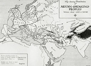
Map showing the distribution of the Aryan speaking peoples between about 1,000 - 500 BC. (print)
7420094 Map showing the distribution of the Aryan speaking peoples between about 1,000 - 500 BC. (print); (add.info.: Map showing the distribution of the Aryan speaking peoples between about 1,000)

Map of Europe, 1848 - 1871. (print)
7420064 Map of Europe, 1848 - 1871. (print); (add.info.: Map of Europe, 1848 - 1871. From the book Outline of History by H.G. Wells, published 1920.); Photo © Ken Welsh. All rights reserved 2024

Background imageMaps Collection: Sketch map showing Boston and neighbourhood, 1775. (print)

Sketch map showing Boston and neighbourhood, 1775. (print)
7420060 Sketch map showing Boston and neighbourhood, 1775. (print); (add.info.: Sketch map showing Boston and neighbourhood, 1775. From the book Outline of History by H.G)

Map of the World showing the chief voyages of exploration, to 1522. (print)
7420054 Map of the World showing the chief voyages of exploration, to 1522. (print); (add.info.: Map of the World showing the chief voyages of exploration, to 1522)

Background imageMaps Collection: Map showing the Timurid Empire (print)

Map showing the Timurid Empire (print)
7420052 Map showing the Timurid Empire (print); Photo © Ken Welsh. All rights reserved 2024.

Background imageMaps Collection: Map of the Ottoman Empire before 1453. (print)

Map of the Ottoman Empire before 1453. (print)
7420051 Map of the Ottoman Empire before 1453. (print); (add.info.: Map of the Ottoman Empire before 1453. From the book Outline of History by H.G. Wells, published 1920.); Photo © Ken Welsh

Background imageMaps Collection: Map of the Mongol States c. 1280 AD and Marco Polo's travels. (print)

Map of the Mongol States c. 1280 AD and Marco Polo's travels. (print)
7420050 Map of the Mongol States c. 1280 AD and Marco Polo's travels. (print); (add.info.: Map of the Mongol States c. 1280 AD and Marco Polo's travels)

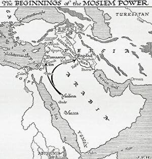
Background imageMaps Collection: Map showing the beginnings of the Moslem Power, 7th century. (print)

Map showing the beginnings of the Moslem Power, 7th century. (print)
7420043 Map showing the beginnings of the Moslem Power, 7th century. (print); (add.info.: Map showing the beginnings of the Moslem Power, 7th century. From the book Outline of History by H.G)

Background imageMaps Collection: Plan of Eagle Island and Bird Island, late 18th to early 19th century (paper)

Plan of Eagle Island and Bird Island, late 18th to early 19th century (paper)
7340731 Plan of Eagle Island and Bird Island, late 18th to early 19th century (paper) by Dalrymple, Alexander (18th-19th century); National Maritime Museum, London

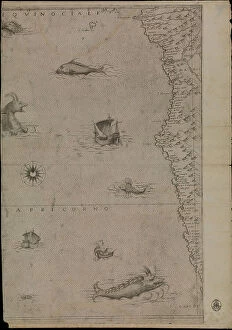
Background imageMaps Collection: Map of Africa, 1564 - 1 of 8 sheets, 1564 (technical drawing)

Map of Africa, 1564 - 1 of 8 sheets, 1564 (technical drawing)
7340677 Map of Africa, 1564 - 1 of 8 sheets, 1564 (technical drawing) by Gastaldi, Giacomo (c.1500-66); National Maritime Museum, London

Background imageMaps Collection: The celestial planisphere or transparent star director, c.1850 (card, paper, tissue)

The celestial planisphere or transparent star director, c.1850 (card, paper, tissue)
7340555 The celestial planisphere or transparent star director, c.1850 (card, paper, tissue) by British School, (19th century); 34.5x34.5 cm; National Maritime Museum, London

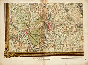
Background imageMaps Collection: Sheet 16 from: An exact survey of the cities of London and Westminster, the Borough of Southwark

Sheet 16 from: An exact survey of the cities of London and Westminster, the Borough of Southwark
7340520 Sheet 16 from: An exact survey of the cities of London and Westminster, the Borough of Southwark, with the country near ten miles round..., 1746 (coloured engraving) by Rocque

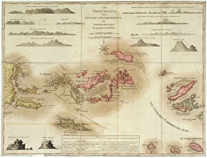
The Virgin Islands from English and Danish surveys, 1775 (engraving)
7340498 The Virgin Islands from English and Danish surveys, 1775 (engraving) by Jefferys, Thomas (c.1719-71); 46.5x62 cm; National Maritime Museum, London

Background imageMaps Collection: Chart of River Medway and part of the Thames: no.24 Sheerness, c.1590 (ink and wash)

Chart of River Medway and part of the Thames: no.24 Sheerness, c.1590 (ink and wash)
7340493 Chart of River Medway and part of the Thames: no.24 Sheerness, c.1590 (ink and wash) by Unknown Artist, (16th century); 40x30 cm; National Maritime Museum, London

Background imageMaps Collection: Chart of Dover Strait, c.1587-88 (watercolour on vellum)

Chart of Dover Strait, c.1587-88 (watercolour on vellum)
7340491 Chart of Dover Strait, c.1587-88 (watercolour on vellum) by Teixeira, Luis (fl.1564-1612); 40x52 cm; National Maritime Museum, London, UK; (add.info.: Creator: Luis Teixeira Single sheet)

The south part of Virginia, 1657 (vellum)
7340490 The south part of Virginia, 1657 (vellum) by Comberford, Nicholas (d.1673); 39x25 cm; National Maritime Museum, London

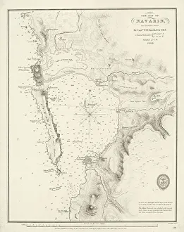
Bay of Navarino, 1830 (print)
7340652 Bay of Navarino, 1830 (print) by Smyth, William Henry (1788-1865); 32.5x25.5 cm; National Maritime Museum, London

Background imageMaps Collection: Detail de la carte 6 de Robert Adams, gravee par Augustine Ryther et montrant la route pratiquee

Detail de la carte 6 de Robert Adams, gravee par Augustine Ryther et montrant la route pratiquee par la flotte de
AIS5373392 Detail de la carte 6 de Robert Adams, gravee par Augustine Ryther et montrant la route pratiquee par la flotte de l'Armada Espagnole ou Invincible Armada vers les iles britanniques

Background imageMaps Collection: Map known as ' Leo belgicus ' (Lion belgique) of the 17 United Provinces of the Netherlands

Map known as " Leo belgicus " (Lion belgique) of the 17 United Provinces of the Netherlands, 1583-85 (map)
AIS5338612 Map known as " Leo belgicus " (Lion belgique) of the 17 United Provinces of the Netherlands, 1583-85 (map); Mercatormuseum, Sint-Niklaas

Background imageMaps Collection: Guayaquil, 1682 (coloured manuscript)

Guayaquil, 1682 (coloured manuscript)
7339327 Guayaquil, 1682 (coloured manuscript) by Ringrose, Basil (c.1653-83); 16x20 cm; National Maritime Museum, London, UK; (add.info.: Creator)


All Professionally Made to Order for Quick Shipping

Maps have always been a fascinating window into the past, allowing us to explore and understand the world as it once was. From the intricate details of an ancient Greek map to the vibrant landscapes of Jamaica, each map tells its own unique story. Take a journey back in time with a Map of Ancient Greece, where you can trace the footsteps of philosophers and warriors alike. Discover the birthplace of democracy and marvel at the city-states that shaped Western civilization. Venture further across continents with Maps showcasing the vastness of empires like Britain's. Explore territories under British rule through a Map of the British Empire or delve into Asia's history with a Map highlighting the mighty Mongol Empire. Uncover remnants of one of history's greatest civilizations with a Map depicting the grandeur and reach of Rome. Witness how this powerful empire spanned across Europe, Africa, and Asia, leaving behind an indelible mark on human history. During times filled with turmoil and conflict, maps served as crucial tools for understanding war efforts. The Daily Mail War Map from World War I provides insights into battlefronts while WW2 posters display strategic plans like never before - including those detailing activities specific to divisions such as 52 (Lowland) Division or mapping out positions held by troops in The British Army. Closer to home lies Isle Of Wight - its beauty captured perfectly on a detailed map inviting exploration along its stunning coastline. Meanwhile, travel even further east to discover ancient Persian splendor through an intricately designed Persian Empire map. For those seeking nostalgia or tracing ancestral roots, immerse yourself in Cornwall C1857's historical charm via an antique map capturing its essence during that era. From ancient civilizations to modern-day conflicts and everything in between – they can not just pieces of paper but gateways into our collective pasts. They hold stories waiting to be unraveled by curious minds eager for knowledge about our ever-changing world throughout time.