
Cosa Collection
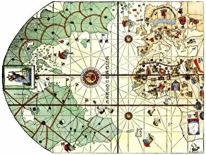
"Exploring the World: Juan de la Cosa's Journey on the Nina" Step back in time to 1500 with this remarkable world map by Juan de la Cosa


All Professionally Made to Order for Quick Shipping
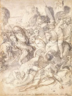
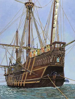
"Exploring the World: Juan de la Cosa's Journey on the Nina" Step back in time to 1500 with this remarkable world map by Juan de la Cosa, a skilled navigator aboard Christopher Columbus' second voyage. Hailing from Spain, de la Cosa meticulously charted the uncharted territories, becoming the first cartographer to depict America. In Madrid's archives, his masterpiece stands as a testament to his pioneering spirit and unwavering determination. It was not only a map but also an invaluable window into the unknown lands that would shape our future. As we delve deeper into history, let us not forget Nao Saint Mary – a vessel that braved treacherous waters alongside courageous explorers like de la Cosa. Its sails billowed against red clouds reflected on Lake Annone in Lecco province, Lombardy, Italy during sunrise – an awe-inspiring sight that reminds us of nature's beauty. Speaking of courage and resilience, Elliot Ness emerges from black-and-white photographs of the 1930s. His relentless pursuit of justice echoes those who fought valiantly at The Battle centuries before him – their story etched onto paper through black chalk and ink. Meanwhile, across oceans and borders, royalty graced Florence with her presence during "The Queen's Visit to Italy. " Engravings captured her admiration for this magnificent city steeped in artistry and culture. Returning to Spanish shores in 1500 brings us face-to-face with another creation by Juan de la Cosa – a detailed map showcasing his homeland's splendor. This work exemplifies his expertise as both cartographer and pilot; it is a testament to his dedication towards unraveling geographical mysteries. Lastly, let us not overlook Columbus' iconic ship - The Santa Maria - which sailed under starry skies more than five centuries ago. A photograph from 1912 transports us back in time when brave souls embarked on perilous journeys, forever changing the course of history.