Fraud Blocker Skip to main content

Compass Roses Collection

"Exploring the Seas

Background imageCompass Roses Collection: Sea chart of the south coast of Cuba and Jamaica, Jan Luyken, Claes Jansz Voogt

Sea chart of the south coast of Cuba and Jamaica, Jan Luyken, Claes Jansz Voogt, Johannes van Keulen (I), 1684 - 1799

Background imageCompass Roses Collection: Sea chart of part of the Irish Sea between Ireland and Britain, and the St George s

Sea chart of part of the Irish Sea between Ireland and Britain, and the St George s
Sea chart of part of the Irish Sea between Ireland and Britain, and the St Georges Channel, with two compass roses, the North is to the right, on the scale are two dogs and a shepherd, Jan Luyken

Background imageCompass Roses Collection: Sea chart of part of southeastern Florida and northeast of Cuba, Jan Luyken, Claes

Sea chart of part of southeastern Florida and northeast of Cuba, Jan Luyken, Claes Jansz Voogt, Johannes van Keulen I, 1684-1799

Background imageCompass Roses Collection: Sea chart of a portion of the west coast of Ireland, Jan Luyken, Anonymous, Johannes van Keulen

Sea chart of a portion of the west coast of Ireland, Jan Luyken, Anonymous, Johannes van Keulen (I), 1681 - 1803

Background imageCompass Roses Collection: Sea chart of the southern part of the Baltic Sea, print maker: Jan Luyken, Johannes

Sea chart of the southern part of the Baltic Sea, print maker: Jan Luyken, Johannes van Keulen I, unknown, 1681 - 1799

Background imageCompass Roses Collection: Sea chart of the northwestern part of the Baltic Sea by the Swedish coast, Jan Luyken

Sea chart of the northwestern part of the Baltic Sea by the Swedish coast, Jan Luyken, Johannes van Keulen (I), unknown, 1681 - 1799

Background imageCompass Roses Collection: Sea chart of part of the east coast of the United States USA, print maker: Jan Luyken

Sea chart of part of the east coast of the United States USA, print maker: Jan Luyken, Claes Jansz Voogt, Johannes van Keulen I, 1684 - 1799

Background imageCompass Roses Collection: Sea chart of the Channel between England and France, Part 2, Anonymous, Johannes van Keulen

Sea chart of the Channel between England and France, Part 2, Anonymous, Johannes van Keulen (I), unknown, 1688 - 1803

Background imageCompass Roses Collection: Sea chart of the Zuiderzee and the Wadden Sea, Jan Luyken, Johannes van Keulen (I)

Sea chart of the Zuiderzee and the Wadden Sea, Jan Luyken, Johannes van Keulen (I), unknown, 1681

Background imageCompass Roses Collection: Sea chart of the coasts of England, Scotland and Ireland, Jan Luyken, Johannes van Keulen

Sea chart of the coasts of England, Scotland and Ireland, Jan Luyken, Johannes van Keulen (I), unknown, 1682 - 1803

Background imageCompass Roses Collection: Sea chart of the mouth of the Gulf of Finland in the Baltic Sea, Jan Luyken, Johannes

Sea chart of the mouth of the Gulf of Finland in the Baltic Sea, Jan Luyken, Johannes van Keulen (I), unknown, 1681 - 1799

Background imageCompass Roses Collection: Sea chart of a portion of the Baltic coast of Poland and Latvia, Jan Luyken, Johannes

Sea chart of a portion of the Baltic coast of Poland and Latvia, Jan Luyken, Johannes van Keulen (I), unknown, 1681 - 1799

Background imageCompass Roses Collection: Sea chart of Northern part of Atlantic and Arctic Ocean, North Sea and Baltic Sea

Sea chart of Northern part of Atlantic and Arctic Ocean, North Sea and Baltic Sea, Jan Luyken, Johannes van Keulen I, unknown, 1681-1799

Background imageCompass Roses Collection: Sea chart of part of the Norwegian coast, Norway, print maker: Jan Luyken, Johannes

Sea chart of part of the Norwegian coast, Norway, print maker: Jan Luyken, Johannes van Keulen I, unknown, 1681 - 1799

Background imageCompass Roses Collection: Sea chart of part of the coast of the Kola peninsula in Russia, Jan Luyken, Johannes van Keulen

Sea chart of part of the coast of the Kola peninsula in Russia, Jan Luyken, Johannes van Keulen (I), unknown, 1681 - 1799

Background imageCompass Roses Collection: Three-piece waiver of Iceland, Jan Mayen Island and Spitsbergen, Jan Luyken, Johannes

Three-piece waiver of Iceland, Jan Mayen Island and Spitsbergen, Jan Luyken, Johannes van Keulen I, unknown, 1681 - 1799

Background imageCompass Roses Collection: Sea chart of the Atlantic Ocean to the west coast of Europe and parts of Africa

Sea chart of the Atlantic Ocean to the west coast of Europe and parts of Africa, Jan Luyken, Johannes van Keulen I, unknown, 1681-1803

Background imageCompass Roses Collection: Sea chart of the southern part of the North Sea and part of the east coast of England

Sea chart of the southern part of the North Sea and part of the east coast of England, Gerard van Keulen, Johannes van Keulen (I), unknown, 1688 - 1803

Background imageCompass Roses Collection: Sea chart of the coast of Ireland, Scotland, England and France, Jan Luyken, Anonymous

Sea chart of the coast of Ireland, Scotland, England and France, Jan Luyken, Anonymous, Johannes van Keulen (I), 1681 - 1803

Background imageCompass Roses Collection: Sea chart of part of the east coast of England at the mouth of the Thames, Jan Luyken

Sea chart of part of the east coast of England at the mouth of the Thames, Jan Luyken, Anonymous, Johannes van Keulen (I), 1681 - 1803

Background imageCompass Roses Collection: Sea chart of the coast of Holland between Texel and the Meuse, Jan Luyken, Anonymous

Sea chart of the coast of Holland between Texel and the Meuse, Jan Luyken, Anonymous, Johannes van Keulen (I), 1681 - 1803

Background imageCompass Roses Collection: Sea chart of part of the Elbe, the Weser and Jadebusen, Jan Luyken, Johannes van Keulen I

Sea chart of part of the Elbe, the Weser and Jadebusen, Jan Luyken, Johannes van Keulen I, unknown, 1681 - 1799

Background imageCompass Roses Collection: Sea chart of part of the coast of Norway, print maker: Jan Luyken, Johannes van Keulen I

Sea chart of part of the coast of Norway, print maker: Jan Luyken, Johannes van Keulen I, unknown, 1681 - 1799

Background imageCompass Roses Collection: Sea chart of the east coast of England, with the mouth of the Humber, Jan Luyken

Sea chart of the east coast of England, with the mouth of the Humber, Jan Luyken, Johannes van Keulen (I), unknown, 1681 - 1799

Background imageCompass Roses Collection: Sea chart of the coast of Norway near Trondheim, Jan Luyken, Johannes van Keulen (I)

Sea chart of the coast of Norway near Trondheim, Jan Luyken, Johannes van Keulen (I), unknown, 1681 - 1799

Background imageCompass Roses Collection: Sea chart of part of the northeast coast of England and part of Scotland, Jan Luyken

Sea chart of part of the northeast coast of England and part of Scotland, Jan Luyken, Johannes van Keulen (I), unknown, 1681 - 1799

Background imageCompass Roses Collection: Sea chart of the northeastern part of the Aegean Sea, the Sea of Marmara and the

Sea chart of the northeastern part of the Aegean Sea, the Sea of Marmara and the Bosphorus, print maker: Anonymous, 1682 - 1803

Background imageCompass Roses Collection: Sea chart of the eastern part of the Mediterranean, Cyprus, Anonymous, Johannes van Keulen

Sea chart of the eastern part of the Mediterranean, Cyprus, Anonymous, Johannes van Keulen (I), unknown, 1682 - 1803

Background imageCompass Roses Collection: Sea chart of the Gulf of Paria to the mouth of the Orinoco river, Orinoquia, Venezuela

Sea chart of the Gulf of Paria to the mouth of the Orinoco river, Orinoquia, Venezuela, Jan Luyken, Claes Jansz Voogt, Johannes van Keulen I, 1684-1799

Background imageCompass Roses Collection: Sea chart of various Surinamese rivers, Jan Luyken, Johannes van Keulen (I), unknown

Sea chart of various Surinamese rivers, Jan Luyken, Johannes van Keulen (I), unknown, 1684 - 1799

Background imageCompass Roses Collection: Sea chart of the coasts of Colombia, Panama, Costa Rica and Honduras, with an inset

Sea chart of the coasts of Colombia, Panama, Costa Rica and Honduras, with an inset map of Cartagena, Jan Luyken, Claes Jansz Voogt, Johannes van Keulen (I), 1684 - 1799

Background imageCompass Roses Collection: Sea chart of part of the Gulf of Mexico, with the coast of Florida, Jan Luyken, Claes

Sea chart of part of the Gulf of Mexico, with the coast of Florida, Jan Luyken, Claes Jansz Voogt, Johannes van Keulen (I), 1684 - 1799

Background imageCompass Roses Collection: Sea chart of the coast of France between the island of Groix and the municipality

Sea chart of the coast of France between the island of Groix and the municipality of La Baule-Escoublac, Anonymous, Claes Jansz Voogt, Johannes van Keulen I, 1681 - 1803

Background imageCompass Roses Collection: Sea chart of a portion of the Bay of Biscay in Bilbao, Anonymous, Claes Jansz Voogt

Sea chart of a portion of the Bay of Biscay in Bilbao, Anonymous, Claes Jansz Voogt, Johannes van Keulen (II), 1734 - 1803

Background imageCompass Roses Collection: Sea chart of part of the south coast of Portugal, Jan Luyken, Anonymous, Johannes van Keulen

Sea chart of part of the south coast of Portugal, Jan Luyken, Anonymous, Johannes van Keulen (I), 1681 - 1803

Background imageCompass Roses Collection: Sea chart of a portion of the south coast of Portugal, Jan Luyken, print maker: Anonymous

Sea chart of a portion of the south coast of Portugal, Jan Luyken, print maker: Anonymous, Johannes van Keulen I, 1681 - 1803

Background imageCompass Roses Collection: Sea map of part of the coast of Portugal, Jan Luyken, Anonymous, Johannes van Keulen I

Sea map of part of the coast of Portugal, Jan Luyken, Anonymous, Johannes van Keulen I, 1681-1803

Background imageCompass Roses Collection: Sea chart of the Strait of Gibraltar, Jan Luyken, Johannes van Keulen (I), unknown

Sea chart of the Strait of Gibraltar, Jan Luyken, Johannes van Keulen (I), unknown, 1682 - 1803

Background imageCompass Roses Collection: Sea chart of a part of the Mediterranean Sea with the coasts of Spain and Algeria

Sea chart of a part of the Mediterranean Sea with the coasts of Spain and Algeria, Anonymous, Johannes van Keulen (I), unknown, 1682 - 1803

Background imageCompass Roses Collection: Sea chart of part of the coast of Brazil in the Most Holy Bay, Jan Luyken, Claes

Sea chart of part of the coast of Brazil in the Most Holy Bay, Jan Luyken, Claes Jansz Voogt, Johannes van Keulen (I), 1683 - 1799

Background imageCompass Roses Collection: Sea map of part of the coast of Brazil, Jan Luyken, Claes Jansz Voogt, Johannes van

Sea map of part of the coast of Brazil, Jan Luyken, Claes Jansz Voogt, Johannes van Keulen I, 1683-1799

Background imageCompass Roses Collection: Sea chart of part of the coast of Virginia, Jan Luyken, Claes Jansz Voogt, Johannes van Keulen

Sea chart of part of the coast of Virginia, Jan Luyken, Claes Jansz Voogt, Johannes van Keulen (I), 1684 - 1799

Background imageCompass Roses Collection: Sea chart of part of the east coast of the United States USA and Canada, print maker

Sea chart of part of the east coast of the United States USA and Canada, print maker: Jan Luyken, Claes Jansz Voogt, Johannes van Keulen I, 1684 - 1799

Background imageCompass Roses Collection: Sea chart a part of the coast of northern Canada and Greenland, with two compass roses

Sea chart a part of the coast of northern Canada and Greenland, with two compass roses, the North is to the left, print maker: Jan Luyken, Dating 1684 - 1799

Background imageCompass Roses Collection: Sea chart of the coast of Namibia and South Africa, Jan Luyken, Johannes van Keulen (I)

Sea chart of the coast of Namibia and South Africa, Jan Luyken, Johannes van Keulen (I), unknown, 1683 - 1799

Background imageCompass Roses Collection: Sea chart of a portion of the northeast coast of Brazil, Jan Luyken, Johannes van Keulen

Sea chart of a portion of the northeast coast of Brazil, Jan Luyken, Johannes van Keulen (I), unknown, 1683 - 1799

Background imageCompass Roses Collection: Sea chart of the east coast of Brazil, Jan Luyken, Claes Jansz Voogt, Johannes van Keulen

Sea chart of the east coast of Brazil, Jan Luyken, Claes Jansz Voogt, Johannes van Keulen (I), 1683 - 1799

Background imageCompass Roses Collection: Sea chart of part of the east coast of Brazil, print maker: Jan Luyken, Claes Jansz Voogt

Sea chart of part of the east coast of Brazil, print maker: Jan Luyken, Claes Jansz Voogt, Johannes van Keulen I, 1683 - 1799


All Professionally Made to Order for Quick Shipping

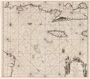
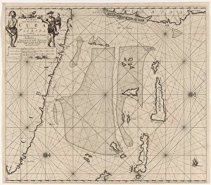
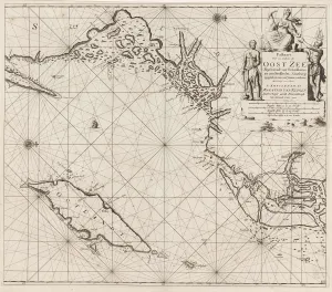
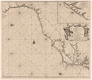
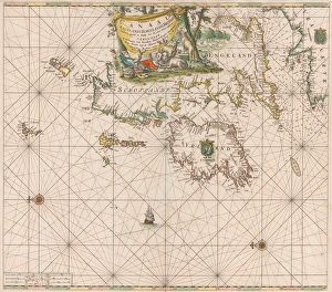
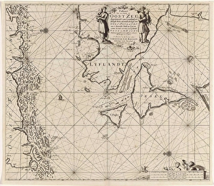
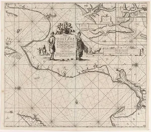
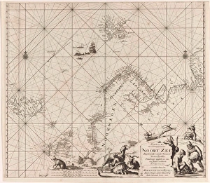
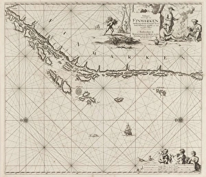
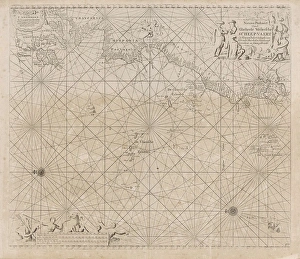
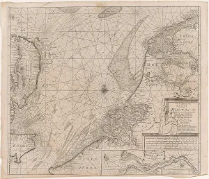
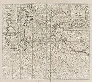
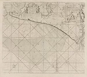
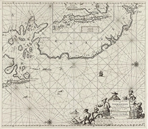
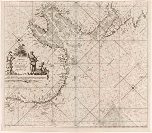
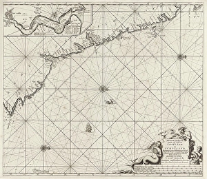
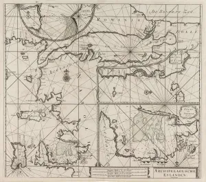
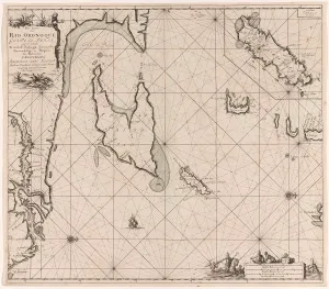
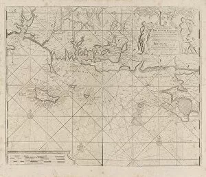
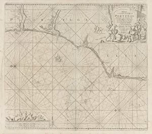
"Exploring the Seas: The Artistry of Compass Roses" Step into a world of maritime exploration with these exquisite compass roses depicted on sea charts from various regions. These intricate designs, created by renowned printmakers such as Jan Luyken, Claes Jansz Voogt, and Johannes van Keulen, not only served as navigational aids but also showcased the artistic prowess of their creators. In "Sea chart of the south coast of Cuba and Jamaica, " we are transported to the Caribbean waters where vibrant colors intertwine to guide sailors through treacherous currents. Luyken's attention to detail is evident in every stroke, capturing both the beauty and dangers that lie beneath. Moving across continents, "Sea chart of part of the Irish Sea between Ireland and Britain" reveals a more subdued palette. Here, St George's Channel comes alive under Anonymous' skillful hand, offering seafarers a clear path amidst rocky shores. Venturing further south brings us to "Sea chart of southeastern Florida and northeast Cuba. " Luyken once again showcases his mastery by seamlessly blending landmasses with swirling waves. This captivating piece serves as a testament to early explorations along these coasts. Heading northwest towards Ireland unveils another gem - "Sea chart of a portion of the west coast. " With its delicate lines and precise markings, this map transports us back in time when brave souls braved unpredictable tides in search for new lands. Crossing over to Baltic waters presents two distinct works - "Sea chart of the southern part" and "northwestern part. " Both charts bear witness to Luyken's versatility as an artist while providing mariners with vital information for safe passage through these challenging seas. Across the Atlantic Ocean lies yet another masterpiece - "Sea chart of part of the east coast USA. " As ships sailed towards promising horizons during America's colonization era, this detailed map guided them along unfamiliar shores using Luyken's signature style.