Home > Arts > Artists > K > Johannes van Keulen
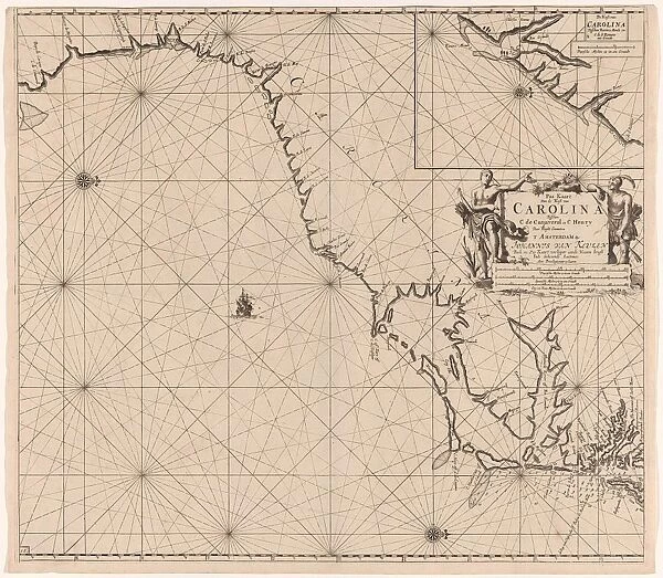
Sea chart of part of the east coast of the United States USA, print maker: Jan Luyken
![]()

Wall Art and Photo Gifts from Liszt Collection
Sea chart of part of the east coast of the United States USA, print maker: Jan Luyken
Sea chart of part of the east coast of the United States USA, print maker: Jan Luyken, Claes Jansz Voogt, Johannes van Keulen I, 1684 - 1799
Liszt Collection of nineteenth-century engravings and images to browse and enjoy
Media ID 12721317
© Quint Lox Limited
1684 1799 Address Archers Weapons Arrow Arrows Bow Arrow Bows Cape Card Claes Jansz Voogt Coast Compass Compass Roses Contains Dark East East Coast French Miles Georgetown Inset Jan Luyken Johannes Van Keulen North Portion Roses Scale Sea Chart States United Canaveral Cape Canaveral Chart
FEATURES IN THESE COLLECTIONS
> Animals
> Insects
> Hemiptera
> Rose Scale
> Arts
> Artists
> K
> Johannes van Keulen
> Arts
> Artists
> L
> Jan Luyken
> Maps and Charts
> World
> North America
> United States of America
> Maps
EDITORS COMMENTS
This print showcases a remarkable sea chart depicting a portion of the east coast of the United States. Created by renowned print makers Jan Luyken, Claes Jansz Voogt, and Johannes van Keulen I between 1684 and 1799, this map is an exquisite example of early cartography. The intricate details on this sea chart are truly awe-inspiring. From Cape Canaveral to Hatteras, every coastal feature is meticulously illustrated, providing valuable geographical information for sailors and explorers alike. The inset featuring Georgetown adds another layer of depth to this already fascinating piece. Compass roses elegantly adorn the corners of the map, guiding navigators with their cardinal directions. The inclusion of French miles further emphasizes its international significance during that era. One cannot help but notice the presence of dark men depicted wielding bows and arrows throughout the chart. This intriguing element hints at encounters with indigenous peoples along these shores during times when exploration was still in its infancy. With its rich historical context and meticulous craftsmanship, this print from Quint Lox's Liszt Collection serves as a window into our past. It reminds us of how far we have come in terms of understanding our world's geography while also honoring those who paved the way for future discoveries.
MADE IN THE USA
Safe Shipping with 30 Day Money Back Guarantee
FREE PERSONALISATION*
We are proud to offer a range of customisation features including Personalised Captions, Color Filters and Picture Zoom Tools
SECURE PAYMENTS
We happily accept a wide range of payment options so you can pay for the things you need in the way that is most convenient for you
* Options may vary by product and licensing agreement. Zoomed Pictures can be adjusted in the Cart.


