Framed Print > Sheffield City Archives > Maps and Plans > Maps of Yorkshire
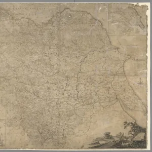
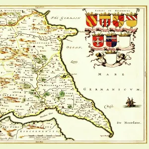
Framed Print : An Accurate Map of the West Riding of Yorkshire, divided into its Wapontakes, 1785


![]()
Framed Photos From Sheffield City Archives
An Accurate Map of the West Riding of Yorkshire, divided into its Wapontakes, 1785
Drawn from Surveys, with various additional Improvements: Illustrated with Historical Extracts relative to its Natural Produce, Mines, Minerals, Manufactures, Trade and the present state of its Principal Towns.
By Emanuel Bowen.
Scale 20 miles : 4.8 inches.
Size 71 x 53 cm.
Original at Sheffield Libraries: y09345
Sheffield City Archives and Local Studies Library has an unrivalled collection of images of Sheffield, England
Media ID 14046971
© Sheffield City Council
12"x10" Modern Frame
Discover the rich history of West Riding of Yorkshire with our exquisite framed print from Media Storehouse. This beautifully detailed map, dating back to 1785, provides an accurate representation of the region's wapentakes. Meticulously drawn from surveys and enhanced with historical extracts, this captivating piece showcases the natural produce, mines, minerals, and manufactures of the time. A perfect addition to any home or office, this framed print is not only an attractive decorative piece but also a fascinating insight into the history of Yorkshire. Bring a piece of the past into your present with Media Storehouse Framed Prints.
10x8 Print in an MDF Wooden Frame with 180 gsm Satin Finish Paper. Glazed using shatter proof thin plexi glass. Frame thickness is 1 inch and depth 0.75 inch. Fluted cardboard backing held with clips. Supplied ready to hang with sawtooth hanger and rubber bumpers. Spot clean with a damp cloth. Packaged foam wrapped in a card.
Contemporary Framed and Mounted Prints - Professionally Made and Ready to Hang
Estimated Image Size (if not cropped) is 25.4cm x 25.4cm (10" x 10")
Estimated Product Size is 30.5cm x 25.4cm (12" x 10")
These are individually made so all sizes are approximate
Artwork printed orientated as per the preview above, with landscape (horizontal) or portrait (vertical) orientation to match the source image.
EDITORS COMMENTS
This print showcases "An Accurate Map of the West Riding of Yorkshire, divided into its Wapontakes" from 1785. The map, drawn by Emanuel Bowen, is a testament to the meticulous surveys and additional improvements made during that time. Measuring at an impressive size of 71 x 53 cm, it offers a detailed representation of the region's natural produce, mines, minerals, manufactures, trade, and the present state of its principal towns. The historical extracts accompanying this map provide valuable insights into the rich heritage and significance of Yorkshire's West Riding. It serves as a window into the past for those seeking to explore and understand this remarkable area. Preserved in Sheffield Libraries' archives under reference number y09345, this original piece holds immense historical value. Its scale is precisely measured at 20 miles : 4.8 inches—allowing viewers to grasp distances accurately within their minds. As one gazes upon this print from Sheffield City Archives, they are transported back in time—a journey through centuries filled with stories waiting to be discovered. Whether you have personal ties to Yorkshire or simply appreciate cartography as an art form and historical resource—the beauty and depth captured within this image will undoubtedly captivate your imagination.
MADE IN THE USA
Safe Shipping with 30 Day Money Back Guarantee
FREE PERSONALISATION*
We are proud to offer a range of customisation features including Personalised Captions, Color Filters and Picture Zoom Tools
SECURE PAYMENTS
We happily accept a wide range of payment options so you can pay for the things you need in the way that is most convenient for you
* Options may vary by product and licensing agreement. Zoomed Pictures can be adjusted in the Basket.