Framed Print > Sheffield City Archives > Maps and Plans > Maps of Sheffield
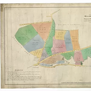
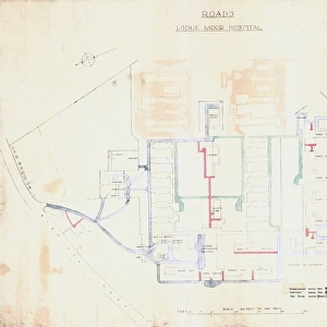
Framed Print : Plan of land for sale situate at Ranmoor, Sheffield, 1869


![]()
Framed Photos from Sheffield City Archives
Plan of land for sale situate at Ranmoor, Sheffield, 1869
S. F. Holmes, Surveyor, Sheffield.
Printed by Pawson and Brailsford.
Three closes of land called The Watt Fields in the occupation of John Elliott, the owner.
Original at Sheffield Libraries: y12222
Sheffield City Archives and Local Studies Library has an unrivalled collection of images of Sheffield, England
Media ID 14086800
© Sheffield City Council
12"x10" Modern Frame
Step back in time with our exclusive Framed Prints from Media Storehouse. This captivating piece showcases an 1869 land plan of Ranmoor, Sheffield, from the Sheffield City Archives. Meticulously surveyed by S.F. Holmes and printed by Pawson and Brailsford, this historic document offers a unique glimpse into the past. The Watt Fields, comprised of three closes of land, were then in the occupation of John Elliott. Add this beautifully framed antique to your decor and bring a piece of Sheffield's rich history into your home.
10x8 Print in an MDF Wooden Frame with 180 gsm Satin Finish Paper. Glazed using shatter proof thin plexi glass. Frame thickness is 1 inch and depth 0.75 inch. Fluted cardboard backing held with clips. Supplied ready to hang with sawtooth hanger and rubber bumpers. Spot clean with a damp cloth. Packaged foam wrapped in a card.
Contemporary Framed and Mounted Prints - Professionally Made and Ready to Hang
Estimated Image Size (if not cropped) is 25.4cm x 25.4cm (10" x 10")
Estimated Product Size is 25.4cm x 30.5cm (10" x 12")
These are individually made so all sizes are approximate
Artwork printed orientated as per the preview above, with landscape (horizontal) or portrait (vertical) orientation to match the source image.
EDITORS COMMENTS
This print from 1869 showcases the "Plan of land for sale situate at Ranmoor, Sheffield". The detailed map was skillfully created by S. F. Holmes, a renowned surveyor in Sheffield during that time. Pawson and Brailsford were responsible for printing this remarkable piece. The plan highlights three closes of land known as The Watt Fields, which were under the ownership of John Elliott. These fields are beautifully captured in the photograph, showcasing their vastness and natural beauty. Located in Yorkshire's picturesque Ranmoor area, this plot is surrounded by notable landmarks such as Fulwood Road, Ranmoor Road, Darwin Lane, Ranmoor Park Road, Watt Lane, Ranmoor Crescent, Tapton Park Road, Ranmoor Inn and Tetney Road. Preserved meticulously at Sheffield Libraries with reference number y12222 within their extensive maps collection; this print serves as a valuable historical artifact providing insights into the development and transformation of Sheffield over time
MADE IN THE USA
Safe Shipping with 30 Day Money Back Guarantee
FREE PERSONALISATION*
We are proud to offer a range of customisation features including Personalised Captions, Color Filters and Picture Zoom Tools
SECURE PAYMENTS
We happily accept a wide range of payment options so you can pay for the things you need in the way that is most convenient for you
* Options may vary by product and licensing agreement. Zoomed Pictures can be adjusted in the Cart.