Framed Print > Europe > United Kingdom > England > London > Sights > British Museum
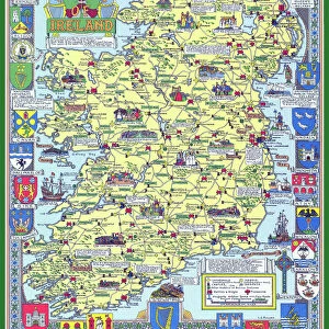
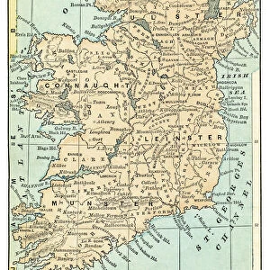
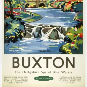
Framed Print : Map of Ireland, BR poster, c 1950s


![]()
Framed Photos from National Railway Museum
Map of Ireland, BR poster, c 1950s
British Railways poster showing the map and the emblems of four counties in Ireland. Artwork by D W Burley
National Railway Museum is the home of iconic locomotives. Our historic prints reflect the age and quality of the original artwork we hold to preserve their artistic character, including authentic colour reproduction, marks and creases.
Media ID 10006566
© Please read our licence terms. All digital images must be destroyed unless otherwise agreed in writing
12"x10" Modern Frame
Step back in time with our vintage Map of Ireland Framed Print, featuring the iconic British Railways poster design from the 1950s. This beautifully preserved piece by D W Burley showcases a detailed map of Ireland, accompanied by the emblems of four counties. A must-have for history enthusiasts, travelers, or anyone who appreciates the charm of mid-century graphic design. Bring a piece of nostalgia into your home or office with our high-quality framed print.
10x8 Print in an MDF Wooden Frame with 180 gsm Satin Finish Paper. Glazed using shatter proof thin plexi glass. Frame thickness is 1 inch and depth 0.75 inch. Fluted cardboard backing held with clips. Supplied ready to hang with sawtooth hanger and rubber bumpers. Spot clean with a damp cloth. Packaged foam wrapped in a card.
Contemporary Framed and Mounted Prints - Professionally Made and Ready to Hang
Estimated Image Size (if not cropped) is 25.4cm x 25.4cm (10" x 10")
Estimated Product Size is 30.5cm x 25.4cm (12" x 10")
These are individually made so all sizes are approximate
Artwork printed orientated as per the preview above, with landscape (horizontal) or portrait (vertical) orientation to match the source image.
FEATURES IN THESE COLLECTIONS
> Europe
> Republic of Ireland
> Maps
> Europe
> United Kingdom
> England
> London
> Sights
> British Museum
> Maps and Charts
> Popular Maps
> Maps and Charts
> Related Images
> Popular Themes
> Railway Posters
> National Railway Museum
> Ireland
EDITORS COMMENTS
This print showcases a remarkable piece of history - the "Map of Ireland, BR poster" from the 1950s. Created by the talented artist D W Burley, this British Railways poster beautifully depicts not only the map of Ireland but also highlights the emblems of four prominent counties within it. The artwork effortlessly captures the essence and diversity of Ireland's rich cultural heritage. Each county emblem represents its unique history, culture, and traditions, inviting viewers to embark on a journey through time and explore these fascinating regions. As we delve into this vintage masterpiece, we are transported back to an era when travel was synonymous with leisure and adventure. This poster served as both a practical guide for tourists and an artistic representation of British Railways' commitment to promoting tourism in Ireland. The National Railway Museum has preserved this gem from yesteryears in their Pictorial Collection. It serves as a testament to how art can transcend time, allowing us to appreciate not only the skillful craftsmanship but also gain insights into historical contexts. Whether you are an avid traveler or simply captivated by Irish culture, this print is sure to ignite your wanderlust and curiosity about this enchanting land. Let it transport you back in time while simultaneously inspiring future explorations!
MADE IN THE USA
Safe Shipping with 30 Day Money Back Guarantee
FREE PERSONALISATION*
We are proud to offer a range of customisation features including Personalised Captions, Color Filters and Picture Zoom Tools
SECURE PAYMENTS
We happily accept a wide range of payment options so you can pay for the things you need in the way that is most convenient for you
* Options may vary by product and licensing agreement. Zoomed Pictures can be adjusted in the Cart.