Framed Print > Europe > United Kingdom > England > Cornwall > Launceston
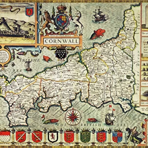
Framed Print : 1832 Victorian Map of Launceston


![]()
Framed Photos From Mary Evans Picture Library
1832 Victorian Map of Launceston
Mary Evans Picture Library makes available wonderful images created for people to enjoy over the centuries
Media ID 32351924
© The Keasbury-Gordon Photograph Archive / Mary Evans
1832 Borough Boroughs Boundaries Boundary Constituencies Constituency Launceston Parliament Parliamentary Reform
12"x10" Modern Frame
Discover the rich history of Launceston with our stunning framed print from The Keasbury-Gordon Photograph Archive Collection at Media Storehouse. This exquisite 1832 Victorian Map of Launceston, sourced from Mary Evans Prints Online, offers a captivating glimpse into the past. The intricate details of the map reveal the layout of the town as it existed over 180 years ago, making it an essential addition to any home or office. The high-quality print is beautifully framed, adding an elegant touch to your decor while transporting you back in time. Bring a piece of historical charm into your space with our 1832 Victorian Map of Launceston Framed Print.
10x8 Print in an MDF Wooden Frame with 180 gsm Satin Finish Paper. Glazed using shatter proof thin plexi glass. Frame thickness is 1 inch and depth 0.75 inch. Fluted cardboard backing held with clips. Supplied ready to hang with sawtooth hanger and rubber bumpers. Spot clean with a damp cloth. Packaged foam wrapped in a card.
Contemporary Framed and Mounted Prints - Professionally Made and Ready to Hang
Estimated Image Size (if not cropped) is 25.4cm x 25.4cm (10" x 10")
Estimated Product Size is 25.4cm x 30.5cm (10" x 12")
These are individually made so all sizes are approximate
Artwork printed orientated as per the preview above, with landscape (horizontal) or portrait (vertical) orientation to match the source image.
FEATURES IN THESE COLLECTIONS
> Europe
> United Kingdom
> England
> Cornwall
> Launceston
> Europe
> United Kingdom
> England
> Cornwall
> Related Images
> Europe
> United Kingdom
> England
> Cornwall
> South Petherwin
> Europe
> United Kingdom
> England
> Cornwall
> Werrington
> Europe
> United Kingdom
> England
> Maps
> Europe
> United Kingdom
> England
> Posters
> Maps and Charts
> Early Maps
> Maps and Charts
> Related Images
> Mary Evans Prints Online
> New Images July 2023
EDITORS COMMENTS
Step back in time with this stunning 1832 Victorian Map of Launceston, a true piece of history captured in intricate detail. This vintage map showcases the boundaries of parliamentary constituencies in the boroughs of South Petherwin, Egloskerry, Lawhitton, and Werrington in Cornwall, England.
The map is a fascinating glimpse into the early days of parliamentary reform, reflecting the changes brought about by the Reform Act. Each boundary line tells a story of political power and representation during this pivotal period in British history.
As you study this Edwardian-era map, you can almost imagine yourself walking through the streets of Launceston as it was over a century ago. The old-world charm and elegance are palpable in every corner, giving us a sense of connection to our ancestors who once roamed these same paths.
This lantern slide print from The Keasbury-Gordon Photograph Archive Collection is not just a decorative piece for your home or office – it's a window into another time. Let yourself be transported back to 1832 as you explore the intricacies of this historical gem.
MADE IN THE USA
Safe Shipping with 30 Day Money Back Guarantee
FREE PERSONALISATION*
We are proud to offer a range of customisation features including Personalised Captions, Color Filters and Picture Zoom Tools
SECURE PAYMENTS
We happily accept a wide range of payment options so you can pay for the things you need in the way that is most convenient for you
* Options may vary by product and licensing agreement. Zoomed Pictures can be adjusted in the Basket.