Framed Print > Historic > Ancient civilizations > Ancient Greece > Greek history
Framed Print : Map of Ancient Greece


Framed Photos from Mary Evans Picture Library
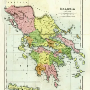
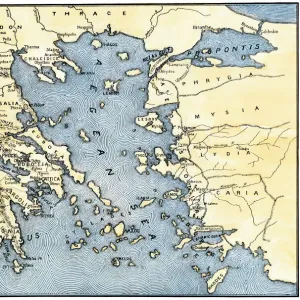
Map of Ancient Greece
A map showing the extent of the Greek Empire and the surrounding territories
Mary Evans Picture Library makes available wonderful images created for people to enjoy over the centuries
Media ID 600235
© Mary Evans Picture Library 2015 - https://copyrighthub.org/s0/hub1/creation/maryevans/MaryEvansPictureID/10137108
Civilisation Extensive Extent Maps Regions Surrounding Territories
18"x14" Modern Frame
Introducing the stunning "Map of Ancient Greece" Framed Print from our Media Storehouse collection, brought to you by Mary Evans Picture Library from Mary Evans Prints Online. This exquisite piece transports you back in time, showcasing the vast expanse of the ancient Greek empire and its surrounding territories in intricate detail. The rich, vibrant colors and meticulous lines bring the history of this legendary civilization to life, making it a captivating addition to any home or office. The high-quality print is beautifully framed in a sleek, modern design, ensuring that it stands out as a conversation starter and a source of inspiration for generations to come. Add this masterpiece to your collection and embark on a journey through the annals of history.
16x12 Print in an MDF Wooden Frame with 180 gsm Satin Finish Paper. Glazed using shatter proof thin plexiglass. Frame thickness is 1 inch and depth 0.75 inch. Fluted cardboard backing held with clips. Supplied ready to hang with sawtooth hanger and rubber bumpers. Spot clean with a damp cloth. Packaged foam wrapped in a card.
Contemporary Framed and Mounted Prints - Professionally Made and Ready to Hang
Estimated Image Size (if not cropped) is 40.6cm x 26.6cm (16" x 10.5")
Estimated Product Size is 45.7cm x 35.6cm (18" x 14")
These are individually made so all sizes are approximate
Artwork printed orientated as per the preview above, with landscape (horizontal) orientation to match the source image.
FEATURES IN THESE COLLECTIONS
> Europe
> Greece
> Related Images
> Europe
> Related Images
> Historic
> Ancient civilizations
> Ancient Greece
> Greek history
> Maps and Charts
> Early Maps
> Maps and Charts
> Popular Maps
> Maps and Charts
> Related Images
> Popular Themes
> Maps and Charts
> Mary Evans Prints Online
> Maps
EDITORS COMMENTS
This stunning print of a "Map of Ancient Greece" from Mary Evans Picture Library offers a fascinating glimpse into the extensive reach of the Greek Empire and its surrounding territories. The intricate details on this historical map showcase the various city-states, regions, and states that made up this ancient civilization dating back to 500 BC.
From Athens to Sparta, this map highlights key cities and landmarks that played significant roles in shaping Greek history and culture. It also illustrates how far-reaching the influence of the Greek Empire was throughout Europe during this time period.
As you study each line and boundary on this map, you can't help but feel transported back in time to an era where philosophy, art, and democracy flourished in these lands. The rich history depicted on this map serves as a reminder of the legacy left behind by one of the most influential civilizations in world history.
Whether you're a history buff or simply appreciate beautiful cartography, this "Map of Ancient Greece" print is sure to spark your curiosity and imagination. Display it proudly in your home or office as a conversation piece that celebrates the enduring impact of ancient Greek civilization.
MADE IN THE USA
Safe Shipping with 30 Day Money Back Guarantee
FREE PERSONALISATION*
We are proud to offer a range of customisation features including Personalised Captions, Color Filters and Picture Zoom Tools
SECURE PAYMENTS
We happily accept a wide range of payment options so you can pay for the things you need in the way that is most convenient for you
* Options may vary by product and licensing agreement. Zoomed Pictures can be adjusted in the Cart.