Framed Print : Map of India Shewing the Lines of Railways, Telegraphs?


![]()
Framed Photos From Mary Evans Picture Library
Map of India Shewing the Lines of Railways, Telegraphs?
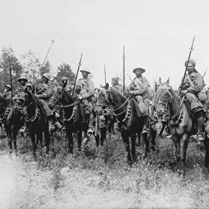
?Map of India Shewing the Lines of Railways, Telegraphs, and Dawk Routes?, specially engraved for the Indian Traveller?s Guide (nd); from papers collected by J P K Murphy, 52nd Sikhs and 9th Hodson?s Horse, after his retirement in 1924. Date: circa 1924
Mary Evans Picture Library makes available wonderful images created for people to enjoy over the centuries
Media ID 14404120
© The National Army Museum / Mary Evans Picture Library
52nd Collected Engraved Guide Hodsons Lines Murphy Papers Railways Retirement Routes Sikhs Specially Telegraphs 1924 Shewing
12"x10" Modern Frame
Discover the rich history and intricate detail of India with our stunning Framed Prints from Media Storehouse. This captivating piece showcases an antique map of India, meticulously engraved and originally published for the Indian Traveller's Guide. The map highlights the extensive railways, telegraph lines, and dawk routes that once connected the vast subcontinent. Add an air of historic charm to your space with this beautifully framed, high-quality print. Perfect for history enthusiasts, world travellers, or anyone looking to add a touch of vintage elegance to their decor.
10x8 Print in an MDF Wooden Frame with 180 gsm Satin Finish Paper. Glazed using shatter proof thin plexi glass. Frame thickness is 1 inch and depth 0.75 inch. Fluted cardboard backing held with clips. Supplied ready to hang with sawtooth hanger and rubber bumpers. Spot clean with a damp cloth. Packaged foam wrapped in a card.
Contemporary Framed and Mounted Prints - Professionally Made and Ready to Hang
Estimated Image Size (if not cropped) is 25.4cm x 25.4cm (10" x 10")
Estimated Product Size is 25.4cm x 30.5cm (10" x 12")
These are individually made so all sizes are approximate
Artwork printed orientated as per the preview above, with landscape (horizontal) or portrait (vertical) orientation to match the source image.
EDITORS COMMENTS
This intricately detailed map, titled 'Map of India Shewing the Lines of Railways, Telegraphs, and Dawk Routes,' offers a glimpse into the extensive communication networks of India during the early 20th century. The map, specially engraved for the Indian Traveller's Guide, was collected by J.P. K. Murphy after his retirement in 1924. The map showcases the extensive railway lines crisscrossing India, connecting major cities and towns. The telegraph lines, another crucial means of communication during this era, are depicted as thin, winding lines, connecting various parts of the country. The dawk routes, a precursor to modern postal services, are indicated by dotted lines. Murphy, a veteran of the Indian Army, served with the 52nd Sikhs and 9th Hodson's Horse. His collection of papers, including this map, provides valuable insights into the transportation and communication infrastructure of India during the British colonial period. The map's meticulous detailing and clear labeling make it an essential tool for travelers and administrators alike, highlighting the importance of effective communication and transportation networks in facilitating movement and commerce within the vast subcontinent. This map offers a fascinating glimpse into the history of India's communication systems, providing a window into the past and shedding light on the significant strides made in connecting India's diverse regions during the early 20th century.
MADE IN THE USA
Safe Shipping with 30 Day Money Back Guarantee
FREE PERSONALISATION*
We are proud to offer a range of customisation features including Personalised Captions, Color Filters and Picture Zoom Tools
SECURE PAYMENTS
We happily accept a wide range of payment options so you can pay for the things you need in the way that is most convenient for you
* Options may vary by product and licensing agreement. Zoomed Pictures can be adjusted in the Basket.