Framed Print > Asia > Myanmar > Maps
Framed Print : Map / Asia / East Indies


![]()
Framed Photos from Mary Evans Picture Library
Map / Asia / East Indies
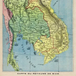
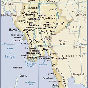
India and its neighbours : note that Burma is named India beyond the Ganges
Mary Evans Picture Library makes available wonderful images created for people to enjoy over the centuries
Media ID 573719
© Mary Evans Picture Library 2015 - https://copyrighthub.org/s0/hub1/creation/maryevans/MaryEvansPictureID/10008892
1780 Burma Indies Maps Named Neighbours Note
12"x10" Modern Frame
Discover the captivating beauty of the East Indies with our exquisite framed print from Mary Evans Picture Library. This stunning Map of Asia, titled "India and its Neighbours: Note that Burma is named India beyond the Ganges," is an essential addition to any room that seeks to showcase the rich history and culture of the region. The intricate details of this vintage map bring to life the diverse landscapes, borders, and territories of India and its neighboring countries. Housed in a high-quality frame, this framed print not only serves as a beautiful decorative piece but also as an educational and conversational piece. Bring a touch of history and world exploration into your home or office with this timeless and captivating framed print from Media Storehouse.
10x8 Print in an MDF Wooden Frame with 180 gsm Satin Finish Paper. Glazed using shatter proof thin plexi glass. Frame thickness is 1 inch and depth 0.75 inch. Fluted cardboard backing held with clips. Supplied ready to hang with sawtooth hanger and rubber bumpers. Spot clean with a damp cloth. Packaged foam wrapped in a card.
Contemporary Framed and Mounted Prints - Professionally Made and Ready to Hang
Estimated Image Size (if not cropped) is 25.4cm x 25.4cm (10" x 10")
Estimated Product Size is 30.5cm x 25.4cm (12" x 10")
These are individually made so all sizes are approximate
Artwork printed orientated as per the preview above, with landscape (horizontal) or portrait (vertical) orientation to match the source image.
FEATURES IN THESE COLLECTIONS
> Asia
> India
> Related Images
> Asia
> Myanmar
> Related Images
> Asia
> Related Images
> Maps and Charts
> Early Maps
> Maps and Charts
> India
> Maps and Charts
> Related Images
EDITORS COMMENTS
This stunning vintage map print from Mary Evans Picture Library showcases the intricate details of Asia and the East Indies in 1780. The map provides a fascinating glimpse into the historical boundaries and names of countries in this region, with a special note that Burma is named India beyond the Ganges. The rich history and cultural significance of these lands are beautifully captured in this piece, offering a unique perspective on how these nations were perceived centuries ago.
The intricate design and careful labeling on this map highlight the importance of cartography in documenting and understanding our world. Each country is clearly delineated, with borders drawn meticulously to show their respective territories. This visual representation serves as a valuable tool for historians, geographers, and enthusiasts alike to study the geopolitical landscape of Asia during this time period.
Whether you have an interest in history, geography, or simply appreciate beautiful artwork, this map print is sure to captivate your imagination. Display it proudly in your home or office to spark conversations about the past and present state of these fascinating regions. Let this piece transport you back in time to an era where exploration and discovery shaped our understanding of the world around us.
MADE IN THE USA
Safe Shipping with 30 Day Money Back Guarantee
FREE PERSONALISATION*
We are proud to offer a range of customisation features including Personalised Captions, Color Filters and Picture Zoom Tools
SECURE PAYMENTS
We happily accept a wide range of payment options so you can pay for the things you need in the way that is most convenient for you
* Options may vary by product and licensing agreement. Zoomed Pictures can be adjusted in the Cart.