Framed Print > Africa > Related Images
Framed Print : Map Africa North


![]()
Framed Photos From Mary Evans Picture Library
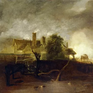
Map Africa North
The most prominent feature is the Mountains of the Moon, separating the Sahara and Soudan Deserts from the unknown territory to the south. Date: 1768
Mary Evans Picture Library makes available wonderful images created for people to enjoy over the centuries
Media ID 14113537
© Mary Evans Picture Library
1768 Deserts Feature Maps Moon Prominent Sahara Separating Soudan Territory Unknown
12"x10" Modern Frame
Discover the captivating beauty of 'Map Africa North' by Rights Managed from Mary Evans Prints Online, showcased in our Media Storehouse Framed Prints collection. This exquisite map, dated 1768, highlights the intriguing Mountains of the Moon, which have long separated the Sahara and Soudan Deserts from the unknown territory to the south. Transport yourself back in time and add a touch of history and wonder to your space with this stunning, framed, and preserved piece of cartographic artistry.
10x8 Print in an MDF Wooden Frame with 180 gsm Satin Finish Paper. Glazed using shatter proof thin plexi glass. Frame thickness is 1 inch and depth 0.75 inch. Fluted cardboard backing held with clips. Supplied ready to hang with sawtooth hanger and rubber bumpers. Spot clean with a damp cloth. Packaged foam wrapped in a card.
Contemporary Framed and Mounted Prints - Professionally Made and Ready to Hang
Estimated Image Size (if not cropped) is 25.4cm x 25.4cm (10" x 10")
Estimated Product Size is 30.5cm x 25.4cm (12" x 10")
These are individually made so all sizes are approximate
Artwork printed orientated as per the preview above, with landscape (horizontal) or portrait (vertical) orientation to match the source image.
EDITORS COMMENTS
This map print, titled 'Map of Africa, North,' dates back to the year 1768, offering a fascinating glimpse into the geographical knowledge of the time. The map, published during the Age of Enlightenment, is a testament to the exploratory spirit and curiosity that characterized the era. The most prominent feature on this map is the 'Mountains of the Moon,' which separates the expansive Sahara and Sudan Deserts from the largely unknown territory to the south. This mountain range, shrouded in mystery and legend, has long intrigued cartographers and explorers alike. The Mountains of the Moon were believed to be the source of the Nile River, a belief that persisted until the late 19th century when the true source was discovered in modern-day Rwanda and Burundi. The map also highlights other notable geographical features, including the Nile River, the Mediterranean Sea, and the Red Sea. The northern coast of Africa is well-defined, with the major cities and regions clearly marked. However, the interior of the continent remains largely unexplored, with vast expanses of 'Terra Incognita,' or unknown territory. This map serves as a reminder of the incomplete understanding of the world that existed before the age of modern exploration and satellite imagery. It also underscores the importance of continued exploration and discovery, as new knowledge helps us expand our horizons and broaden our perspective of the world around us.
MADE IN THE USA
Safe Shipping with 30 Day Money Back Guarantee
FREE PERSONALISATION*
We are proud to offer a range of customisation features including Personalised Captions, Color Filters and Picture Zoom Tools
FREE COLORIZATION SERVICE
You can choose advanced AI Colorization for this picture at no extra charge!
SECURE PAYMENTS
We happily accept a wide range of payment options so you can pay for the things you need in the way that is most convenient for you
* Options may vary by product and licensing agreement. Zoomed Pictures can be adjusted in the Basket.