Framed Print > Arts > Artists > O > John Ogilby
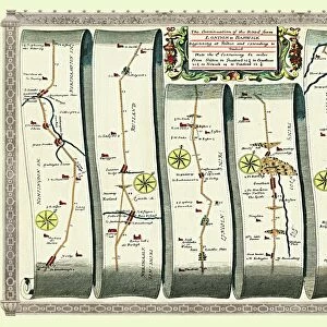
Framed Print : Old Road Strip Map (PLATE 9) The Continuation of the Road from London to Barwick
 The Continuation of the Road from London to Barwick")

 The Continuation of the Road from London to Barwick")

![]()
Framed Photos from MapSeeker
Old Road Strip Map (PLATE 9) The Continuation of the Road from London to Barwick
OLG009
Welcome to the Mapseeker Image library and enter an historic gateway to one of the largest on-line collections of Historic Maps, Nostalgic Views, Vista's and Panorama's from a World gone by.
Media ID 20347299
John Ogilby Ogilby Old Road Strip Map Strip Map
18"x14" Modern Frame
Step back in time with our Old Road Strip Map Framed Print from Media Storehouse. Featuring Plate 9 of "The Continuation of the Road from London to Barwick" by MapSeeker, this vintage map offers a captivating glimpse into the past. The intricate details of the winding roads and quaint villages bring history to life in your home or office. Each print is carefully framed to preserve its antique charm, making it a unique and thoughtful addition to your decor. Travel back in time with the Old Road Strip Map Framed Print - Plate 9 (OLG009) from Media Storehouse.
16x12 Print in an MDF Wooden Frame with 180 gsm Satin Finish Paper. Glazed using shatter proof thin plexiglass. Frame thickness is 1 inch and depth 0.75 inch. Fluted cardboard backing held with clips. Supplied ready to hang with sawtooth hanger and rubber bumpers. Spot clean with a damp cloth. Packaged foam wrapped in a card.
Contemporary Framed and Mounted Prints - Professionally Made and Ready to Hang
Estimated Image Size (if not cropped) is 40.6cm x 35.6cm (16" x 14")
Estimated Product Size is 45.7cm x 35.6cm (18" x 14")
These are individually made so all sizes are approximate
Artwork printed orientated as per the preview above, with landscape (horizontal) orientation to match the source image.
FEATURES IN THESE COLLECTIONS
> Arts
> Artists
> O
> John Ogilby
> MapSeeker
> Old Railway and Canal Map Collection
> Early Coaching Routes and Canal Maps
EDITORS COMMENTS
Caption: This print showcases a remarkable piece of history, the "Old Road Strip Map (PLATE 9) The Continuation of the Road from London to Barwick" by John Ogilby. As an iconic strip map created during the late 17th century, it offers a fascinating glimpse into the past and serves as a testament to Ogilby's pioneering cartographic work. The intricate details on this old road strip map are truly awe-inspiring. It traces the route from bustling London all the way to Barwick, presenting an invaluable visual representation of one of England's most important thoroughfares during that era. Each landmark, village, and milestone is meticulously depicted along this historic road journey. John Ogilby's expertise in surveying and mapping shines through in this masterpiece. His dedication to accuracy and precision is evident in every stroke of his pen. This particular plate captures not only his exceptional skill but also provides insights into transportation networks and societal connections at that time. As we gaze upon this print today, we can't help but marvel at how much has changed since then while appreciating our shared heritage with those who traveled these roads centuries ago. This artwork invites us to reflect on our own journeys and connects us with generations long gone
MADE IN THE USA
Safe Shipping with 30 Day Money Back Guarantee
FREE PERSONALISATION*
We are proud to offer a range of customisation features including Personalised Captions, Color Filters and Picture Zoom Tools
SECURE PAYMENTS
We happily accept a wide range of payment options so you can pay for the things you need in the way that is most convenient for you
* Options may vary by product and licensing agreement. Zoomed Pictures can be adjusted in the Cart.