Framed Print > Europe > United Kingdom > Scotland > Edinburgh > Edinburgh
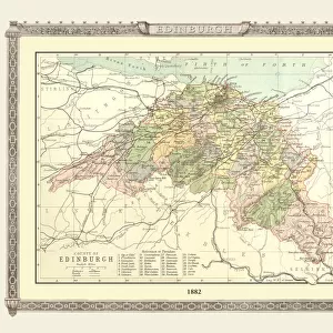
Framed Print : Old Map of the Environs of Edinburgh from the Philips Handy Atlas of 1882


![]()
Framed Photos From MapSeeker
Old Map of the Environs of Edinburgh from the Philips Handy Atlas of 1882
PHA011
Welcome to the Mapseeker Image library and enter an historic gateway to one of the largest on-line collections of Historic Maps, Nostalgic Views, Vista's and Panorama's from a World gone by.
Media ID 20348199
12"x10" Modern Frame
Step back in time with our exquisite Framed Print from Media Storehouse's Old Map Collection. This beautiful piece features an Old Map of the Environs of Edinburgh, taken from the Philips Handy Atlas of 1882, obtained from MapSeeker. The intricate details and authentic antique look of this map transport you to a bygone era. Each print comes carefully framed in a high-quality wooden frame, adding to the timeless appeal. A perfect addition to any room, this framed print is not only a beautiful decorative piece, but also a fascinating glimpse into Edinburgh's rich history.
10x8 Print in an MDF Wooden Frame with 180 gsm Satin Finish Paper. Glazed using shatter proof thin plexi glass. Frame thickness is 1 inch and depth 0.75 inch. Fluted cardboard backing held with clips. Supplied ready to hang with sawtooth hanger and rubber bumpers. Spot clean with a damp cloth. Packaged foam wrapped in a card.
Contemporary Framed and Mounted Prints - Professionally Made and Ready to Hang
Estimated Image Size (if not cropped) is 25.4cm x 25.4cm (10" x 10")
Estimated Product Size is 30.5cm x 25.4cm (12" x 10")
These are individually made so all sizes are approximate
Artwork printed orientated as per the preview above, with landscape (horizontal) or portrait (vertical) orientation to match the source image.
FEATURES IN THESE COLLECTIONS
> Europe
> United Kingdom
> Scotland
> Edinburgh
> Edinburgh
> Europe
> United Kingdom
> Scotland
> Edinburgh
> Europe
> United Kingdom
> Scotland
> Lothian
> Edinburgh
> Europe
> United Kingdom
> Scotland
> Maps
> Maps and Charts
> Early Maps
> MapSeeker
> Maps from the British Isles
> Scotland and Counties PORTFOLIO
EDITORS COMMENTS
This print showcases an exquisite piece of history, the "Old Map of the Environs of Edinburgh from the Philips Handy Atlas of 1882". Transporting us back in time, this Scottish environs map offers a fascinating glimpse into the past. With intricate details and delicate craftsmanship, it beautifully captures the essence of Edinburgh's surroundings during that era. As we explore this historic map, we are immersed in a bygone world where bustling streets and charming villages intertwine with lush green landscapes. The carefully drawn boundaries reveal the extent to which Edinburgh's influence stretched beyond its city limits. Every corner holds tales waiting to be discovered – ancient castles guarding their secrets, winding rivers leading to hidden treasures, and quaint towns brimming with life. This old environs map serves as a portal to another time, inviting us to embark on a journey through centuries past. The rich historical significance of this Edinburgh environs map cannot be overstated. It not only provides invaluable insights into urban development but also sheds light on how communities flourished amidst nature's embrace. Whether you are an avid historian or simply captivated by Scotland's allure, this remarkable print is sure to ignite your imagination and spark conversations about our shared heritage
MADE IN THE USA
Safe Shipping with 30 Day Money Back Guarantee
FREE PERSONALISATION*
We are proud to offer a range of customisation features including Personalised Captions, Color Filters and Picture Zoom Tools
SECURE PAYMENTS
We happily accept a wide range of payment options so you can pay for the things you need in the way that is most convenient for you
* Options may vary by product and licensing agreement. Zoomed Pictures can be adjusted in the Basket.