Framed Print > Europe > United Kingdom > Scotland > Edinburgh > Edinburgh
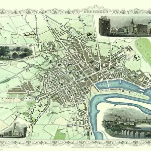
Framed Print : Old Map of Edinburgh 1834 by the S. D. U. K


![]()
Framed Photos From MapSeeker
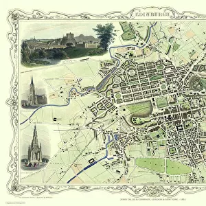
Old Map of Edinburgh 1834 by the S. D. U. K
F006
Welcome to the Mapseeker Image library and enter an historic gateway to one of the largest on-line collections of Historic Maps, Nostalgic Views, Vista's and Panorama's from a World gone by.
Media ID 20347096
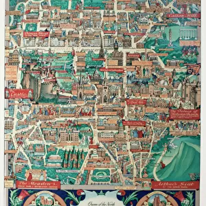
Edinburgh Historic Map Old Town Plan Edinburgh City
18"x14" Modern Frame
Step back in time with our Old Map of Edinburgh 1834 by S. D. U. K from MapSeeker, now available as a beautiful Framed Print from Media Storehouse. This antique map offers a fascinating glimpse into the history and layout of Edinburgh over 180 years ago. The intricate details and authentic cartography make this an essential addition to any home or office space. Our high-quality Framed Prints are meticulously crafted to preserve the rich details of the map and protect it from fading or damage. Add a touch of history and character to your décor with this captivating piece from Media Storehouse.
16x12 Print in an MDF Wooden Frame with 180 gsm Satin Finish Paper. Glazed using shatter proof thin plexiglass. Frame thickness is 1 inch and depth 0.75 inch. Fluted cardboard backing held with clips. Supplied ready to hang with sawtooth hanger and rubber bumpers. Spot clean with a damp cloth. Packaged foam wrapped in a card.
Contemporary Framed and Mounted Prints - Professionally Made and Ready to Hang
Estimated Image Size (if not cropped) is 40.6cm x 35.6cm (16" x 14")
Estimated Product Size is 45.7cm x 35.6cm (18" x 14")
These are individually made so all sizes are approximate
Artwork printed orientated as per the preview above, with landscape (horizontal) orientation to match the source image.
FEATURES IN THESE COLLECTIONS
> Europe
> United Kingdom
> Heritage Sites
> Old and New Towns of Edinburgh
> Europe
> United Kingdom
> Scotland
> Edinburgh
> Edinburgh
> Europe
> United Kingdom
> Scotland
> Lothian
> Edinburgh
> MapSeeker
> British Town And City Plans
> Scottish PORTFOLIO
EDITORS COMMENTS
This print showcases the "Old Map of Edinburgh 1834" created by the S. D. U. K. (Society for the Diffusion of Useful Knowledge). Steeped in history, this remarkable map offers a glimpse into the past, allowing us to explore and appreciate the city's rich heritage. Dating back to 1834, this meticulously detailed town plan of Edinburgh presents a fascinating snapshot of what life was like during that era. The intricate cartography highlights every nook and cranny of Scotland's capital city, from its bustling streets to its iconic landmarks. As we delve into this historic map, we are transported back in time to an Edinburgh that has long since evolved. We can trace the winding paths through the Old Town and marvel at its medieval architecture. The majestic silhouette of Edinburgh Castle looms proudly over Princes Street Gardens, while Holyrood Palace stands regally at one end of the Royal Mile. Every street corner tells a story on this old map; each name evokes memories and whispers secrets from centuries gone by. It is as if we are walking alongside our ancestors as they navigate their way through these familiar streets. Whether you have personal ties to Edinburgh or simply appreciate historical cartography, this print serves as a cherished reminder of how cities evolve yet retain their unique charm throughout time. Display it proudly in your home or office space and allow yourself to be transported back in time with every glance.
MADE IN THE USA
Safe Shipping with 30 Day Money Back Guarantee
FREE PERSONALISATION*
We are proud to offer a range of customisation features including Personalised Captions, Color Filters and Picture Zoom Tools
SECURE PAYMENTS
We happily accept a wide range of payment options so you can pay for the things you need in the way that is most convenient for you
* Options may vary by product and licensing agreement. Zoomed Pictures can be adjusted in the Basket.