Framed Print > Arts > Artists > T > John Tallis
Framed Print : Old Map of Cork Ireland 1851 by John Tallis


![]()
Framed Photos From MapSeeker
Old Map of Cork Ireland 1851 by John Tallis
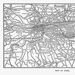
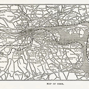
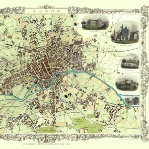
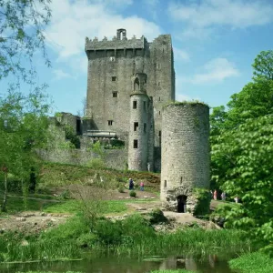
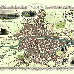
In this Victorian map of Cork in southern Ireland by John Tallis the North and South channels of the River Lee flow through the centre of the plan with the extensive Barracks dominating the northeast. There are four picturesque views of Cork. These views are of Black Rock Castle, Queenstown Harbour Cove of Cork, Old Weir Bridge Killarney and Blarney Castle
Welcome to the Mapseeker Image library and enter an historic gateway to one of the largest on-line collections of Historic Maps, Nostalgic Views, Vista's and Panorama's from a World gone by.
Media ID 20347886
Historic Map John Tallis John Tallis Map Old Town Plan Tallis Map Cork Cork City
18"x14" Modern Frame
Step back in time with our exquisite Framed Print of the Old Map of Cork, Ireland 1851 by John Tallis from MapSeeker. This captivating Victorian map transports you to the heart of Cork City with its intricate detailing of the North and South channels of the River Lee. The extensive Barracks, a dominant feature of the map, adds to the historical charm. Bring the rich history of Cork into your home or office with this beautifully framed print, a timeless piece that tells a story and adds character to any space.
16x12 Print in an MDF Wooden Frame with 180 gsm Satin Finish Paper. Glazed using shatter proof thin plexiglass. Frame thickness is 1 inch and depth 0.75 inch. Fluted cardboard backing held with clips. Supplied ready to hang with sawtooth hanger and rubber bumpers. Spot clean with a damp cloth. Packaged foam wrapped in a card.
Contemporary Framed and Mounted Prints - Professionally Made and Ready to Hang
Estimated Image Size (if not cropped) is 40.6cm x 35.6cm (16" x 14")
Estimated Product Size is 45.7cm x 35.6cm (18" x 14")
These are individually made so all sizes are approximate
Artwork printed orientated as per the preview above, with landscape (horizontal) orientation to match the source image.
FEATURES IN THESE COLLECTIONS
> Arts
> Artists
> T
> John Tallis
> Europe
> Republic of Ireland
> Cork
> Europe
> Republic of Ireland
> Maps
> Historic
> Medieval architecture
> Castles and fortresses
> Historic castles
> Popular Themes
> Blarney Castle
> MapSeeker
> British Town And City Plans
> Irish PORTFOLIO
EDITORS COMMENTS
This stunning print showcases an exquisite Victorian map of Cork, Ireland, created by the talented John Tallis in 1851. The intricate details and artistry of this old map transport us back to a time when the city was flourishing with charm and history. The focal point of this map is undoubtedly the North and South channels of the River Lee, gracefully flowing through the heart of Cork's center. As we explore further, our eyes are drawn to the magnificent Barracks that dominate the northeast corner, symbolizing their significance during that era. What truly sets this piece apart are the four enchanting views captured within its borders. Black Rock Castle stands proudly against a picturesque backdrop while Queenstown Harbour Cove reveals its tranquil beauty. Old Weir Bridge in Killarney exudes a sense of serenity as it spans over gentle waters, while Blarney Castle evokes a sense of wonderment with its legendary stone. As we delve into this historic treasure trove, we can't help but marvel at how much has changed since Tallis first crafted this masterpiece. Yet amidst all transformations and progressions, one thing remains constant - Cork's timeless allure and rich heritage continue to captivate hearts across generations.
MADE IN THE USA
Safe Shipping with 30 Day Money Back Guarantee
FREE PERSONALISATION*
We are proud to offer a range of customisation features including Personalised Captions, Color Filters and Picture Zoom Tools
SECURE PAYMENTS
We happily accept a wide range of payment options so you can pay for the things you need in the way that is most convenient for you
* Options may vary by product and licensing agreement. Zoomed Pictures can be adjusted in the Basket.