Framed Print > Maps and Charts > Related Images
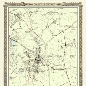
Framed Print : Old Map of the Village of Streetly near Sutton Coldfield 1918


![]()
Framed Photos from MapSeeker
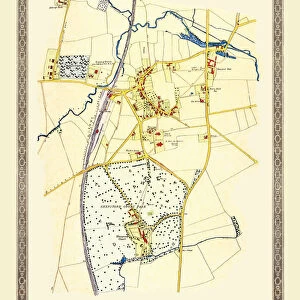
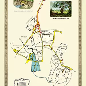
Old Map of the Village of Streetly near Sutton Coldfield 1918
PL015
Welcome to the Mapseeker Image library and enter an historic gateway to one of the largest on-line collections of Historic Maps, Nostalgic Views, Vista's and Panorama's from a World gone by.
Media ID 20347132
18"x14" Modern Frame
Discover the rich history of your community with our exquisite Old Map of the Village of Streetly near Sutton Coldfield 1918 from MapSeeker. Part of the Media Storehouse Framed Prints collection, this vintage map brings a piece of the past into your home or office. The intricate details and authentic colors of the map are beautifully preserved, making it a fascinating conversation starter and a unique decorative piece. This framed print is a must-have for anyone with a connection to Streetly or an appreciation for historical maps. Bring history to life with this captivating addition to your space.
16x12 Print in an MDF Wooden Frame with 180 gsm Satin Finish Paper. Glazed using shatter proof thin plexiglass. Frame thickness is 1 inch and depth 0.75 inch. Fluted cardboard backing held with clips. Supplied ready to hang with sawtooth hanger and rubber bumpers. Spot clean with a damp cloth. Packaged foam wrapped in a card.
Contemporary Framed and Mounted Prints - Professionally Made and Ready to Hang
Estimated Image Size (if not cropped) is 40.6cm x 35.6cm (16" x 14")
Estimated Product Size is 45.7cm x 35.6cm (18" x 14")
These are individually made so all sizes are approximate
Artwork printed orientated as per the preview above, with landscape (horizontal) orientation to match the source image.
FEATURES IN THESE COLLECTIONS
> Maps and Charts
> Related Images
> MapSeeker
> British Town And City Plans
> English & Welsh PORTFOLIO
EDITORS COMMENTS
This print showcases an exquisite piece of history, the "Old Map of the Village of Streetly near Sutton Coldfield 1918". Immerse yourself in a bygone era as you explore the intricate details and fascinating landmarks depicted on this vintage map. With its delicate lines and faded hues, it evokes a sense of nostalgia for a time long past. The map offers a glimpse into the quaint village life that once thrived in Streetly. Every street, building, and pathway is meticulously illustrated, allowing us to trace the footsteps of those who walked these very lanes over a century ago. As we study this historic artifact, we can almost hear echoes from the past whispering tales of community gatherings at charming cottages or bustling markets filled with lively conversations. Streetly's rich heritage comes alive through this remarkable print. It serves as both an educational resource for historians and an enchanting decoration for any space yearning to be infused with character and charm. Whether you are a local resident seeking to connect with your roots or simply fascinated by historical cartography, this old map will transport you back in time
MADE IN THE USA
Safe Shipping with 30 Day Money Back Guarantee
FREE PERSONALISATION*
We are proud to offer a range of customisation features including Personalised Captions, Color Filters and Picture Zoom Tools
SECURE PAYMENTS
We happily accept a wide range of payment options so you can pay for the things you need in the way that is most convenient for you
* Options may vary by product and licensing agreement. Zoomed Pictures can be adjusted in the Cart.