Framed Print > MapSeeker > British Town And City Plans > English & Welsh PORTFOLIO
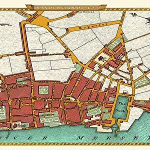
Framed Print : Old Map of Map of Liverpool Surveyed in 1795 by John Stockdale


![]()
Framed Photos From MapSeeker
Old Map of Map of Liverpool Surveyed in 1795 by John Stockdale
J016
Welcome to the Mapseeker Image library and enter an historic gateway to one of the largest on-line collections of Historic Maps, Nostalgic Views, Vista's and Panorama's from a World gone by.
Media ID 20347977
City Of Liverpool Map Historic Liverpool Map Historic Map Liverpool Liverpool City Liverpool City Map Liverpool Map Liverpool Town Plan Map Of Liverpool Old Map Of Liverpool Old Town Plan Town Plan Of Liverpool Stockdale
18"x14" Modern Frame
Step back in time with our exquisite Framed Print from Media Storehouse, featuring an Old Map of Liverpool surveyed in 1795 by John Stockdale. This vintage map, sourced from MapSeeker (J016), is a captivating addition to any room. The intricate details and historical significance of this antique chart are beautifully preserved behind the high-quality frame, making it a unique and thoughtful gift or an elegant decorative piece for your home or office. Travel back in history and add a touch of timeless charm to your space with Media Storehouse Framed Prints.
16x12 Print in an MDF Wooden Frame with 180 gsm Satin Finish Paper. Glazed using shatter proof thin plexiglass. Frame thickness is 1 inch and depth 0.75 inch. Fluted cardboard backing held with clips. Supplied ready to hang with sawtooth hanger and rubber bumpers. Spot clean with a damp cloth. Packaged foam wrapped in a card.
Contemporary Framed and Mounted Prints - Professionally Made and Ready to Hang
Estimated Image Size (if not cropped) is 40.6cm x 35.6cm (16" x 14")
Estimated Product Size is 45.7cm x 35.6cm (18" x 14")
These are individually made so all sizes are approximate
Artwork printed orientated as per the preview above, with landscape (horizontal) orientation to match the source image.
EDITORS COMMENTS
This print showcases an exquisite piece of history, the "Old Map of Liverpool Surveyed in 1795" by John Stockdale. Steeped in nostalgia and charm, this map offers a fascinating glimpse into the past, allowing us to traverse the streets and alleyways of Liverpool as it stood over two centuries ago. With meticulous detail and precision, Stockdale's survey captures the essence of this bustling maritime city during its formative years. Every street, building, and landmark is meticulously depicted on this beautifully preserved town plan. From the iconic waterfront with its bustling docks to the intricate network of narrow lanes that wind through the heart of Liverpool's historic center, this map immerses us in a bygone era. As we explore this remarkable artifact, we are transported back to a time when Liverpool was rapidly evolving into one of Britain's most important trading ports. The map whispers tales of merchants haggling over goods at bustling markets while ships from around the world docked along its shores. Beyond being a mere geographical representation, this old map serves as a testament to Liverpool's rich heritage and enduring spirit. It reminds us that beneath our modern metropolis lies layers upon layers of stories waiting to be discovered. Whether you are an avid historian or simply captivated by maps' allure, allow yourself to get lost within these intricately drawn lines and immerse yourself in Liverpool's vibrant past captured forever on John Stockdale's masterful creation.
MADE IN THE USA
Safe Shipping with 30 Day Money Back Guarantee
FREE PERSONALISATION*
We are proud to offer a range of customisation features including Personalised Captions, Color Filters and Picture Zoom Tools
SECURE PAYMENTS
We happily accept a wide range of payment options so you can pay for the things you need in the way that is most convenient for you
* Options may vary by product and licensing agreement. Zoomed Pictures can be adjusted in the Basket.