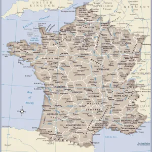
Framed Print : France pittoresque, map Charente, 19th century engraving


![]()
Framed Photos From Liszt Collection
France pittoresque, map Charente, 19th century engraving
Liszt Collection of nineteenth-century engravings and images to browse and enjoy
Media ID 12807165
© Quint Lox Limited
12"x10" Modern Frame
Transport yourself to the charming countryside of 19th century France with our exquisite Framed Print from the Media Storehouse Liszt Collection. This captivating piece features a detailed map of the picturesque Charente region, beautifully rendered in intricate engraving. Each line and contour tells a story of a bygone era, inviting you to explore the rich history and culture of this beloved part of France. Hang this timeless work of art in your home or office to add an air of sophistication and nostalgia. A perfect addition to any space that seeks to celebrate the beauty of the past.
10x8 Print in an MDF Wooden Frame with 180 gsm Satin Finish Paper. Glazed using shatter proof thin plexi glass. Frame thickness is 1 inch and depth 0.75 inch. Fluted cardboard backing held with clips. Supplied ready to hang with sawtooth hanger and rubber bumpers. Spot clean with a damp cloth. Packaged foam wrapped in a card.
Contemporary Framed and Mounted Prints - Professionally Made and Ready to Hang
Estimated Image Size (if not cropped) is 25.4cm x 25.4cm (10" x 10")
Estimated Product Size is 30.5cm x 25.4cm (12" x 10")
These are individually made so all sizes are approximate
Artwork printed orientated as per the preview above, with landscape (horizontal) or portrait (vertical) orientation to match the source image.
EDITORS COMMENTS
This 19th-century engraving from the Liszt Collection transports us back in time to the picturesque landscapes of France. Titled "France pittoresque, map Charente" this print showcases the beauty and charm of the Charente region. The intricate details and delicate lines of the engraving bring to life a bygone era, capturing our imagination with its timeless appeal. The enchanting scenery depicted in this artwork invites us to explore every nook and cranny of Charente's rolling hills, meandering rivers, and quaint villages. Each stroke on paper seems to whisper stories of a simpler time when horse-drawn carriages roamed these idyllic streets. As we gaze upon this vintage map, we can almost feel ourselves strolling through cobblestone alleys lined with charming half-timbered houses. The artist's skillful rendering allows us to envision ourselves sipping wine at a local vineyard or indulging in delicious regional cuisine at one of Charente's traditional bistros. Beyond its aesthetic appeal, this engraving serves as a historical document that captures an important period in French history. It reminds us of the rich cultural heritage embedded within each corner of France – a country known for its artistry, romance, and joie de vivre. Whether you are an avid collector or simply appreciate fine art, this 19th-century engraving is sure to captivate your senses and transport you on an imaginary journey through France's scenic landscapes.
MADE IN THE USA
Safe Shipping with 30 Day Money Back Guarantee
FREE PERSONALISATION*
We are proud to offer a range of customisation features including Personalised Captions, Color Filters and Picture Zoom Tools
SECURE PAYMENTS
We happily accept a wide range of payment options so you can pay for the things you need in the way that is most convenient for you
* Options may vary by product and licensing agreement. Zoomed Pictures can be adjusted in the Basket.