Framed Print > Europe > France > Canton > Landes
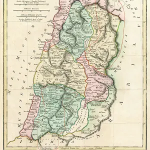
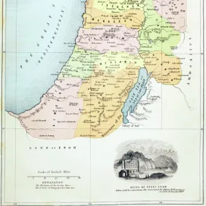
Framed Print : Map of Palestine based on ancient authors, c1830


![]()
Framed Photos From Heritage Images
Map of Palestine based on ancient authors, c1830
Map of Palestine showing distances in Roman miles, based on various ancient authors and the Jerusalem Itinerary. Engraving c1830
Heritage Images features heritage image collections
Media ID 14837867
© Ann Ronan Picture Library / Heritage-Images
Dispute Distance Measurement Israel Land Measurement Palestine Territory Ann Ronan Pictures
12"x10" Modern Frame
Discover the rich history of Palestine with our exquisite framed print, featuring a rare and intriguing map from Heritage Images. Dating back to approximately 1830, this stunning engraving depicts a detailed map of Palestine as described by ancient authors, complete with distances given in Roman miles. Add an air of sophistication and historical charm to any room with this beautifully preserved piece, now available framed in our high-quality frames. A perfect addition to any home office, library, or study, this unique print is sure to spark conversation and inspire a deeper appreciation for the history of the region. Order now and bring a piece of the past into your home.
10x8 Print in an MDF Wooden Frame with 180 gsm Satin Finish Paper. Glazed using shatter proof thin plexi glass. Frame thickness is 1 inch and depth 0.75 inch. Fluted cardboard backing held with clips. Supplied ready to hang with sawtooth hanger and rubber bumpers. Spot clean with a damp cloth. Packaged foam wrapped in a card.
Contemporary Framed and Mounted Prints - Professionally Made and Ready to Hang
Estimated Image Size (if not cropped) is 25.4cm x 25.4cm (10" x 10")
Estimated Product Size is 25.4cm x 30.5cm (10" x 12")
These are individually made so all sizes are approximate
Artwork printed orientated as per the preview above, with landscape (horizontal) or portrait (vertical) orientation to match the source image.
FEATURES IN THESE COLLECTIONS
> Arts
> Artists
> R
> Roman Roman
> Arts
> Literature
> Asia
> Israel
> Related Images
> Asia
> Palestine
> Jerusalem
> Asia
> Palestine
> Related Images
> Europe
> France
> Canton
> Landes
EDITORS COMMENTS
This print showcases a Map of Palestine based on ancient authors, dating back to the 19th century. The intricate details and precise measurements in Roman miles provide us with a unique insight into the historical significance of this land. Crafted through engraving techniques, this artwork beautifully captures the essence of Christianity, Bible stories, and Roman influence. The map serves as a testament to the ongoing dispute over territory between Israel and Palestine. It highlights the religious importance of this region for various faiths and sheds light on its rich cultural heritage. As we delve into its intricacies, we are transported back in time to an era when Italy was at the forefront of artistic expression. Created by an unknown artist, this print offers a glimpse into how literature and arts have played pivotal roles in documenting history throughout centuries. Its inclusion in Ann Ronan Pictures collection further solidifies its value as a significant piece worth cherishing. Whether you're an avid historian or simply intrigued by ancient civilizations, this Map of Palestine will undoubtedly captivate your imagination. Let it transport you to a time long gone while appreciating the meticulous craftsmanship that went into creating such an exquisite piece of art.
MADE IN THE USA
Safe Shipping with 30 Day Money Back Guarantee
FREE PERSONALISATION*
We are proud to offer a range of customisation features including Personalised Captions, Color Filters and Picture Zoom Tools
SECURE PAYMENTS
We happily accept a wide range of payment options so you can pay for the things you need in the way that is most convenient for you
* Options may vary by product and licensing agreement. Zoomed Pictures can be adjusted in the Basket.