Framed Print > Europe > United Kingdom > England > London > Towns > Hammersmith
Framed Print : A map of Fulham in 1813 (1911)
")

")

![]()
Framed Photos From Heritage Images
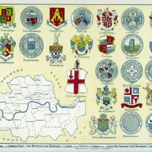
A map of Fulham in 1813 (1911)
A map of Fulham in 1813 (1911). From London - North of the Thames, by Sir Walter Besant. [Adam & Charles Black, London, 1911]
Heritage Images features heritage image collections
Media ID 14971226
© The Print Collector
Besant Cartography Fulham Hammersmith And Fulham Map Making Sir Walter Sir Walter Besant Walter Walter Besant
12"x10" Modern Frame
Step back in time with our exquisite Framed Print of A Map of Fulham in 1813 (1911), a fascinating historical representation of this London borough. Originally published in the book "London - North of the Thames" by Sir Walter Besant, this detailed map was produced by Adam & Charles Black in 1911. Add an air of sophistication and charm to your home or office decor with this beautifully preserved piece of history. Perfect for history enthusiasts, map collectors, or anyone who appreciates the beauty of the past. Each print is carefully framed and ready to hang, making it a unique and captivating addition to your space. Bring history to life with Media Storehouse Framed Prints.
10x8 Print in an MDF Wooden Frame with 180 gsm Satin Finish Paper. Glazed using shatter proof thin plexi glass. Frame thickness is 1 inch and depth 0.75 inch. Fluted cardboard backing held with clips. Supplied ready to hang with sawtooth hanger and rubber bumpers. Spot clean with a damp cloth. Packaged foam wrapped in a card.
Contemporary Framed and Mounted Prints - Professionally Made and Ready to Hang
Estimated Image Size (if not cropped) is 25.4cm x 25.4cm (10" x 10")
Estimated Product Size is 30.5cm x 25.4cm (12" x 10")
These are individually made so all sizes are approximate
Artwork printed orientated as per the preview above, with landscape (horizontal) or portrait (vertical) orientation to match the source image.
FEATURES IN THESE COLLECTIONS
> Arts
> Artists
> W
> Charles White
> Europe
> United Kingdom
> England
> London
> Boroughs
> Hammersmith and Fulham
> Europe
> United Kingdom
> England
> London
> River Thames
> Europe
> United Kingdom
> England
> London
> Towns
> Fulham
> Europe
> United Kingdom
> England
> London
> Towns
> Hammersmith
> Europe
> United Kingdom
> England
> Maps
> Europe
> United Kingdom
> England
> Rivers
> Maps and Charts
> Related Images
EDITORS COMMENTS
This print takes us back in time to the year 1813, providing a glimpse into the historical landscape of Fulham, London. The map, originally published in 1911 by Sir Walter Besant as part of his book "London - North of the Thames" showcases the intricate cartography skills prevalent during that era. The monochrome aesthetic adds an air of nostalgia to this nineteenth-century engraving, allowing us to appreciate its artistic value. It highlights not only the geographical features but also captures the essence of British history and culture. As we explore this detailed map, we are transported through time and space, immersing ourselves in a bygone era. Fulham's close proximity to the River Thames is evident from this depiction, emphasizing its significance as a riverside location within England's capital city. This map serves as a valuable resource for historians and geography enthusiasts alike who wish to study or understand how Fulham evolved over centuries. The print collector responsible for preserving this piece has done an exceptional job in ensuring its longevity. While it may not be used commercially due to copyright restrictions associated with Sir Walter Besant's work, it remains an invaluable asset for those seeking insights into Fulham's past. Overall, this remarkable print invites us on a journey through time and offers a unique perspective on both British cartography and local history.
MADE IN THE USA
Safe Shipping with 30 Day Money Back Guarantee
FREE PERSONALISATION*
We are proud to offer a range of customisation features including Personalised Captions, Color Filters and Picture Zoom Tools
SECURE PAYMENTS
We happily accept a wide range of payment options so you can pay for the things you need in the way that is most convenient for you
* Options may vary by product and licensing agreement. Zoomed Pictures can be adjusted in the Basket.