Framed Print > Granger Art on Demand > Native Americans
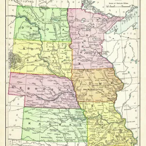
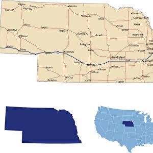
Framed Print : MAP: NEBRASKA, 1899. Indian land cessions in Nebraska. Lithograph, 1899


![]()
Framed Photos from Granger
MAP: NEBRASKA, 1899. Indian land cessions in Nebraska. Lithograph, 1899
MAP: NEBRASKA, 1899.
Indian land cessions in Nebraska. Lithograph, 1899
Granger holds millions of images spanning more than 25,000 years of world history, from before the Stone Age to the dawn of the Space Age
Media ID 12229322
1899 Nebraska Reservation Cession
18"x14" Modern Frame
Step back in time with our exclusive Framed Print from Media Storehouse, featuring the captivating historical map "MAP: NEBRASKA, 1899. Indian land cessions in Nebraska." This intriguing lithograph, published by The Granger Collection from Granger Art on Demand, offers a glimpse into the past, depicting the significant land cessions in Nebraska during the late 19th century. With its antique charm and rich detail, this vintage map is sure to make a stunning addition to any home or office decor. Order now and let history come alive in your space.
16x12 Print in an MDF Wooden Frame with 180 gsm Satin Finish Paper. Glazed using shatter proof thin plexiglass. Frame thickness is 1 inch and depth 0.75 inch. Fluted cardboard backing held with clips. Supplied ready to hang with sawtooth hanger and rubber bumpers. Spot clean with a damp cloth. Packaged foam wrapped in a card.
Contemporary Framed and Mounted Prints - Professionally Made and Ready to Hang
Estimated Image Size (if not cropped) is 40.6cm x 35.6cm (16" x 14")
Estimated Product Size is 45.7cm x 35.6cm (18" x 14")
These are individually made so all sizes are approximate
Artwork printed orientated as per the preview above, with landscape (horizontal) orientation to match the source image.
EDITORS COMMENTS
This lithograph, titled "MAP: NEBRASKA, 1899. Indian land cessions in Nebraska" takes us back to the late 19th century and offers a glimpse into the historical landscape of Native American reservations in Nebraska. Created in 1899, this lithograph showcases the turn of the century's fascination with cartography and serves as an important document of American history. The intricate details on this print highlight various Indian land cessions within Nebraska during that time period. It provides valuable insights into the complex relationship between indigenous tribes and settlers during westward expansion. The map not only displays reservation boundaries but also includes text describing specific areas where land was transferred from Native Americans to non-indigenous individuals or entities. As we examine this lithograph closely, we can appreciate its artistic qualities as well. The careful craftsmanship evident in each line and contour demonstrates the skillful execution by its creators at The Granger Collection. This piece is a testament to their dedication to preserving historical artifacts through art. "MAP: NEBRASKA, 1899" transports us back over a century ago when America was undergoing significant changes both politically and culturally. It invites us to reflect upon our nation's past while acknowledging the impact it had on Indigenous communities whose ancestral lands were gradually diminished through these cessions. Whether you are an avid history enthusiast or simply appreciate fine artwork, this lithograph offers a unique opportunity to connect with America's rich heritage and gain deeper insight into our collective story.
MADE IN THE USA
Safe Shipping with 30 Day Money Back Guarantee
FREE PERSONALISATION*
We are proud to offer a range of customisation features including Personalised Captions, Color Filters and Picture Zoom Tools
SECURE PAYMENTS
We happily accept a wide range of payment options so you can pay for the things you need in the way that is most convenient for you
* Options may vary by product and licensing agreement. Zoomed Pictures can be adjusted in the Cart.