Framed Print > North America > United States of America > Maps
Framed Print : Map of usa north east states 1900


![]()
Framed Photos from Fine Art Storehouse
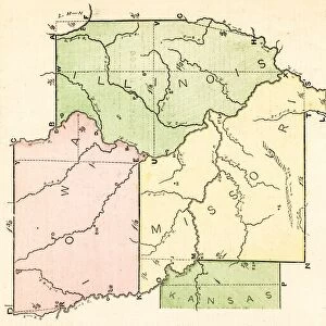
Map of usa north east states 1900
Meyers hand-Atlas Leipzig und Wien Verlag des Bibliographischen Instituts 1900
Unleash your creativity and transform your space into a visual masterpiece!
THEPALMER
Media ID 18106845
© 2014 Roberto Adrian Photography
12"x10" Modern Frame
Step back in time with our vintage Map of the Northeastern USA from ThePalmer's Hand-Atlas, published by Meyers Verlag Leipzig und Wien in 1900. This Framed Print from Media Storehouse showcases intricate details and historical accuracy, transporting you to an era of exploration and discovery. The antique map design adds a unique touch to any room, making it a perfect addition to your home or office decor. Relive history with this beautiful and authentic piece of cartographic art.
10x8 Print in an MDF Wooden Frame with 180 gsm Satin Finish Paper. Glazed using shatter proof thin plexi glass. Frame thickness is 1 inch and depth 0.75 inch. Fluted cardboard backing held with clips. Supplied ready to hang with sawtooth hanger and rubber bumpers. Spot clean with a damp cloth. Packaged foam wrapped in a card.
Contemporary Framed and Mounted Prints - Professionally Made and Ready to Hang
Estimated Image Size (if not cropped) is 25.4cm x 25.4cm (10" x 10")
Estimated Product Size is 30.5cm x 25.4cm (12" x 10")
These are individually made so all sizes are approximate
Artwork printed orientated as per the preview above, with landscape (horizontal) or portrait (vertical) orientation to match the source image.
FEATURES IN THESE COLLECTIONS
> Fine Art Storehouse
> Map
> Historical Maps
> Fine Art Storehouse
> Map
> USA Maps
> North America
> United States of America
> Maps
EDITORS COMMENTS
This photo print, titled "Map of USA North East States 1900" takes us on a journey back in time to the turn of the century. A true gem from Meyers Hand-Atlas Leipzig und Wien Verlag des Bibliographischen Instituts, this vintage map showcases the intricate details and artistry that were characteristic of cartography during that era. The map focuses specifically on the northeastern states of America, offering a glimpse into their geographical features and boundaries as they stood in 1900. The careful craftsmanship is evident in every stroke and contour, allowing us to appreciate both the accuracy and aesthetic appeal of this historical piece. As we gaze upon this mesmerizing artwork by THEPALMER, we are transported to an era when exploration was at its peak. It serves as a reminder of how far we have come since then, highlighting the growth and development these states have undergone over more than a century. Whether you're an avid history enthusiast or simply captivated by beautiful works of art, this print is sure to leave you enchanted. Its timeless charm makes it a perfect addition to any space - be it your home office or study room - where it can spark conversations about our nation's past while adding elegance and sophistication to your decor.
MADE IN THE USA
Safe Shipping with 30 Day Money Back Guarantee
FREE PERSONALISATION*
We are proud to offer a range of customisation features including Personalised Captions, Color Filters and Picture Zoom Tools
SECURE PAYMENTS
We happily accept a wide range of payment options so you can pay for the things you need in the way that is most convenient for you
* Options may vary by product and licensing agreement. Zoomed Pictures can be adjusted in the Cart.