Framed Print > North America > United States of America > Maps
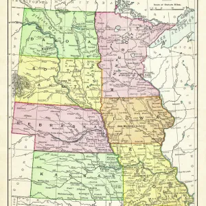
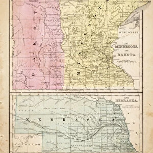
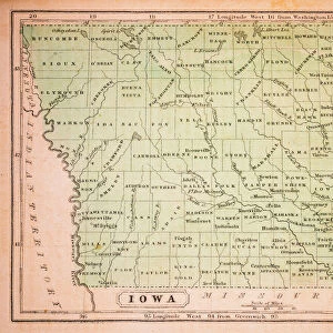
Framed Print : Map of central States USA 1877


![]()
Framed Photos From Fine Art Storehouse
Map of central States USA 1877
Warrens Common School Geography 1877
Unleash your creativity and transform your space into a visual masterpiece!
THEPALMER
Media ID 14824561
© This content is subject to copyright
Iowa Kansas Minnesota Missouri Nebraska North Dakota South Dakota
12"x10" Modern Frame
Step back in time with our exquisite Framed Print of "Map of Central States USA 1877" by THEPALMER from the Fine Art Storehouse at Media Storehouse. This intricately detailed map, originally published in Warren's Common School Geography in 1877, offers a captivating glimpse into American history. The vintage charm of this map is beautifully preserved in our high-quality frame, making it a stunning addition to any home or office. Perfect for history enthusiasts, educators, or anyone who appreciates the beauty of historical cartography, this Framed Print is sure to make a statement in your space. Bring a piece of the past into your present with Media Storehouse.
10x8 Print in an MDF Wooden Frame with 180 gsm Satin Finish Paper. Glazed using shatter proof thin plexi glass. Frame thickness is 1 inch and depth 0.75 inch. Fluted cardboard backing held with clips. Supplied ready to hang with sawtooth hanger and rubber bumpers. Spot clean with a damp cloth. Packaged foam wrapped in a card.
Contemporary Framed and Mounted Prints - Professionally Made and Ready to Hang
Estimated Image Size (if not cropped) is 25.4cm x 25.4cm (10" x 10")
Estimated Product Size is 25.4cm x 30.5cm (10" x 12")
These are individually made so all sizes are approximate
Artwork printed orientated as per the preview above, with landscape (horizontal) or portrait (vertical) orientation to match the source image.
FEATURES IN THESE COLLECTIONS
> Maps and Charts
> Related Images
> North America
> United States of America
> Iowa
> Related Images
> North America
> United States of America
> Kansas
> Related Images
> North America
> United States of America
> Maps
> North America
> United States of America
> Minnesota
> Related Images
> North America
> United States of America
> Missouri
> Related Images
> North America
> United States of America
> Nebraska
> Related Images
> North America
> United States of America
> North Dakota
> Related Images
> North America
> United States of America
> South Dakota
> Related Images
EDITORS COMMENTS
This print titled "Map of central States USA 1877" takes us on a journey back in time to the late 19th century. The image showcases an authentic map from Warren's Common School Geography, published in 1877, providing a glimpse into the geographical landscape of central states such as North Dakota, South Dakota, Iowa, Kansas, Minnesota, Missouri, and Nebraska. The intricate details and delicate lines draw our attention to each state's boundaries and major cities that existed over a century ago. It is fascinating to observe how these regions were depicted before modern advancements transformed their landscapes. The map serves as a historical artifact that not only educates but also sparks curiosity about the past. "The Map of Central States USA 1877" carries an air of nostalgia and invites us to reflect upon the changes these areas have undergone since then. As we study this piece closely, we can almost imagine ourselves exploring those territories during that era - envisioning horse-drawn carriages traversing dirt roads or settlers embarking on new adventures across vast prairies. This remarkable artwork by THEPALMER captures both history enthusiasts' hearts and those with an appreciation for fine art. Its presence adds depth and character to any space it graces while serving as a reminder of our ever-evolving world.
MADE IN THE USA
Safe Shipping with 30 Day Money Back Guarantee
FREE PERSONALISATION*
We are proud to offer a range of customisation features including Personalised Captions, Color Filters and Picture Zoom Tools
SECURE PAYMENTS
We happily accept a wide range of payment options so you can pay for the things you need in the way that is most convenient for you
* Options may vary by product and licensing agreement. Zoomed Pictures can be adjusted in the Basket.