Framed Print > Arts > Photorealistic artworks > Detailed art pieces > Masterful detailing in art
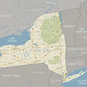
Framed Print : Map of Massachusetts with highways


![]()
Framed Photos from Fine Art Storehouse
Map of Massachusetts with highways
A detailed map of Massachusetts state with cities, roads, major rivers, and lakes. Includes neighboring states and surrounding water
Unleash your creativity and transform your space into a visual masterpiece!
Media ID 15495527
18"x14" Modern Frame
Discover the beauty and depth of Massachusetts with our exquisite Framed Prints from Media Storehouse. This stunning piece showcases a detailed map of the Massachusetts state, meticulously designed to bring out the intricacies of its geography. With clear representations of cities, major rivers, lakes, and highways, this map offers a captivating glimpse into the region's unique character. The neighboring states and surrounding water bodies add to the comprehensive and visually appealing presentation. Bring a touch of New England charm to your home or office with this fine art masterpiece.
16x12 Print in an MDF Wooden Frame with 180 gsm Satin Finish Paper. Glazed using shatter proof thin plexiglass. Frame thickness is 1 inch and depth 0.75 inch. Fluted cardboard backing held with clips. Supplied ready to hang with sawtooth hanger and rubber bumpers. Spot clean with a damp cloth. Packaged foam wrapped in a card.
Contemporary Framed and Mounted Prints - Professionally Made and Ready to Hang
Estimated Image Size (if not cropped) is 40.6cm x 35.6cm (16" x 14")
Estimated Product Size is 45.7cm x 35.6cm (18" x 14")
These are individually made so all sizes are approximate
Artwork printed orientated as per the preview above, with landscape (horizontal) orientation to match the source image.
FEATURES IN THESE COLLECTIONS
> Fine Art Storehouse
> Map
> Reference Maps
> Animals
> Mammals
> Muridae
> Water Mouse
> Arts
> Landscape paintings
> Waterfall and river artworks
> River artworks
> Arts
> Photorealistic artworks
> Detailed art pieces
> Masterful detailing in art
> Maps and Charts
> Related Images
EDITORS COMMENTS
This print showcases a meticulously detailed map of Massachusetts, offering an intricate depiction of the state's highways, cities, roads, major rivers, and lakes. With utmost precision and clarity, this artwork from Fine Art Storehouse brings to life the geographical essence of Massachusetts in all its splendor. The map not only encompasses the entirety of Massachusetts but also includes neighboring states and surrounding water bodies. Its comprehensive scope allows viewers to gain a holistic understanding of the region's geographic context within New England. From bustling urban centers like Boston to picturesque coastal towns such as Cape Cod or Martha's Vineyard, every city and town is intricately marked on this stunning piece. The vibrant colors employed in this print further enhance its visual appeal while ensuring that each detail stands out vividly. Whether you are a history enthusiast tracing colonial roots or an avid traveler planning your next adventure through scenic routes and hidden gems, this map serves as an invaluable resource for exploration. Perfect for both educational purposes or simply as a striking decor element in any space, this print effortlessly combines functionality with aesthetic beauty. It invites viewers to embark on a journey across the diverse landscapes that make up Massachusetts while appreciating the artistry behind cartography itself.
MADE IN THE USA
Safe Shipping with 30 Day Money Back Guarantee
FREE PERSONALISATION*
We are proud to offer a range of customisation features including Personalised Captions, Color Filters and Picture Zoom Tools
SECURE PAYMENTS
We happily accept a wide range of payment options so you can pay for the things you need in the way that is most convenient for you
* Options may vary by product and licensing agreement. Zoomed Pictures can be adjusted in the Cart.