Framed Print > Arts > Contemporary art > Digital artwork > Street art
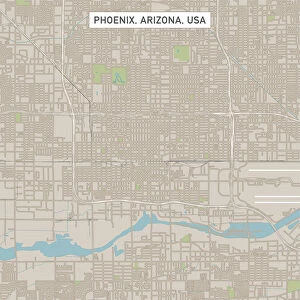
Framed Print : MA Plymouth Vector Road Map


![]()
Framed Photos from Fine Art Storehouse
MA Plymouth Vector Road Map
MA Plymouth Vector Road Map. All source data is in the public domain. U.S. Census Bureau Census Tiger. Used Layers: areawater, linearwater, roads, rails, cousub, pointlm, uac10
Unleash your creativity and transform your space into a visual masterpiece!
Frank Ramspott
Media ID 20692895
© Frank Ramspott, all rights reserved
City Map Computer Graphic County Digital Composite District Geographical Border Harbor Massachusetts Plymouth Road Map Text Vector Cape Cod Bay Digitally Generated Image Duxbury
12"x10" Modern Frame
Discover the unique blend of art and functionality with our MA Plymouth Vector Road Map Framed Print from Media Storehouse. This stunning piece by Frank Ramspott, sourced from Fine Art Storehouse, transforms the classic road map into a work of art. Each detail, from the intricate road networks to the precise water features, is meticulously rendered in vector format using U.S. Census Bureau data. Hang this captivating print in your home or office to add a distinctly modern and intellectual touch to your decor. With all source data in the public domain, you can be confident in the accuracy and authenticity of this piece. Experience the fusion of art and technology with Media Storehouse's MA Plymouth Vector Road Map Framed Print.
10x8 Print in an MDF Wooden Frame with 180 gsm Satin Finish Paper. Glazed using shatter proof thin plexi glass. Frame thickness is 1 inch and depth 0.75 inch. Fluted cardboard backing held with clips. Supplied ready to hang with sawtooth hanger and rubber bumpers. Spot clean with a damp cloth. Packaged foam wrapped in a card.
Contemporary Framed and Mounted Prints - Professionally Made and Ready to Hang
Estimated Image Size (if not cropped) is 25.4cm x 25.4cm (10" x 10")
Estimated Product Size is 25.4cm x 30.5cm (10" x 12")
These are individually made so all sizes are approximate
Artwork printed orientated as per the preview above, with landscape (horizontal) or portrait (vertical) orientation to match the source image.
FEATURES IN THESE COLLECTIONS
> Fine Art Storehouse
> Map
> Reference Maps
> Animals
> Mammals
> Cats (Wild)
> Tiger
> Animals
> Mammals
> Muridae
> Water Mouse
> Arts
> Contemporary art
> Digital artwork
> Street art
> Arts
> Landscape paintings
> Waterfall and river artworks
> River artworks
> Arts
> Portraits
> Pop art gallery
> Street art portraits
> Arts
> Street art graffiti
> Digital art
> Digital paintings
> Maps and Charts
> Related Images
> Popular Themes
> Lake District
EDITORS COMMENTS
This print showcases the intricate details of a Massachusetts Plymouth Vector Road Map. Created by Frank Ramspott, this digitally generated image is a stunning example of cartography and design. The map encompasses various layers including areawater, linearwater, roads, rails, cousub, pointlm, and uac10 - all sourced from the public domain U. S. Census Bureau Census Tiger data. In this colorful and vibrant composition, no people are present as the focus lies solely on the physical geography of Plymouth County. The vector format allows for precise rendering of geographical borders, cities, streets, rivers, lakes and coastlines. Notable landmarks such as Duxbury and Cape Cod Bay can be identified along with Manomet Beach and its surrounding sea harbor. The attention to detail in this digital composite is truly remarkable as every element has been meticulously crafted to create an accurate representation of Plymouth's road network and water bodies. This visually appealing map serves both functional purposes for navigation while also being aesthetically pleasing due to its computer graphic nature. Whether you're a lover of maps or simply appreciate fine art that celebrates our world's diverse landscapes; this print will surely captivate your imagination with its vivid colors and intricate details.
MADE IN THE USA
Safe Shipping with 30 Day Money Back Guarantee
FREE PERSONALISATION*
We are proud to offer a range of customisation features including Personalised Captions, Color Filters and Picture Zoom Tools
SECURE PAYMENTS
We happily accept a wide range of payment options so you can pay for the things you need in the way that is most convenient for you
* Options may vary by product and licensing agreement. Zoomed Pictures can be adjusted in the Cart.