Framed Print > Maps and Charts > Related Images
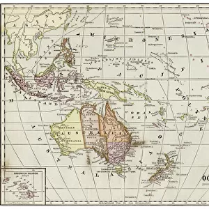
Framed Print : Map of Oceania 1868


![]()
Framed Photos From Fine Art Storehouse
Map of Oceania 1868
Guyots The Earth Common School Geography - 1868
Unleash your creativity and transform your space into a visual masterpiece!
THEPALMER
Media ID 20251073
© A 2014 Roberto Adrian Photography
12"x10" Modern Frame
Discover the rich history of Oceania with our exquisite framed print, "Map of Oceania 1868" by THEPALMER from our Media Storehouse Fine Art collection. This captivating vintage map, published by Guyot's The Earth Common School Geography in 1868, showcases intricate detail and accurate cartography of the Oceania region during that time. Elevate your home or office decor with this unique and educational piece, available in a beautifully crafted frame that preserves and enhances the artwork's antique charm. Bring a touch of history and geography to your space with our Framed Map of Oceania 1868.
10x8 Print in an MDF Wooden Frame with 180 gsm Satin Finish Paper. Glazed using shatter proof thin plexi glass. Frame thickness is 1 inch and depth 0.75 inch. Fluted cardboard backing held with clips. Supplied ready to hang with sawtooth hanger and rubber bumpers. Spot clean with a damp cloth. Packaged foam wrapped in a card.
Contemporary Framed and Mounted Prints - Professionally Made and Ready to Hang
Estimated Image Size (if not cropped) is 25.4cm x 25.4cm (10" x 10")
Estimated Product Size is 30.5cm x 25.4cm (12" x 10")
These are individually made so all sizes are approximate
Artwork printed orientated as per the preview above, with landscape (horizontal) or portrait (vertical) orientation to match the source image.
FEATURES IN THESE COLLECTIONS
> Maps and Charts
> Related Images
EDITORS COMMENTS
This photo print, titled "Map of Oceania 1868" takes us on a mesmerizing journey back in time. A relic from the past, this piece hails from Guyots The Earth Common School Geography - 1868 and is now brought to life by THEPALMER through Fine Art Storehouse. The map itself is an exquisite depiction of Oceania as it stood in the late 19th century. With intricate details and delicate craftsmanship, it offers a glimpse into the world as explorers once knew it. From Australia's vast expanse to the scattered islands dotting the Pacific Ocean, every corner of this diverse region comes alive with vibrant colors and precise cartographic accuracy. As we delve deeper into this historical gem, we can't help but marvel at its educational significance. This map would have been an invaluable tool for students during its time—a window into distant lands that sparked curiosity and ignited imaginations. It serves as a reminder of how knowledge was disseminated before modern technology took over classrooms. Beyond its academic value, however, lies an undeniable aesthetic appeal. The aged texture adds character to the print while enhancing our appreciation for its vintage charm. Whether displayed in a study or adorning the walls of a history enthusiast's home, this artwork effortlessly transports us back to an era when exploration was paramount. In essence, "Map of Oceania 1868" invites us to embark on a visual voyage through time—an opportunity to rediscover our planet's past while embracing
MADE IN THE USA
Safe Shipping with 30 Day Money Back Guarantee
FREE PERSONALISATION*
We are proud to offer a range of customisation features including Personalised Captions, Color Filters and Picture Zoom Tools
SECURE PAYMENTS
We happily accept a wide range of payment options so you can pay for the things you need in the way that is most convenient for you
* Options may vary by product and licensing agreement. Zoomed Pictures can be adjusted in the Basket.