Framed Print > Europe > Italy > Maps
Framed Print : Map of North Italy 1900


![]()
Framed Photos From Fine Art Storehouse
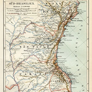
Map of North Italy 1900
Meyers hand-Atlas Leipzig und Wien Verlag des Bibliographischen Instituts 1900
Unleash your creativity and transform your space into a visual masterpiece!
THEPALMER
Media ID 18106851
© 2014 Roberto Adrian Photography
12"x10" Modern Frame
Discover the rich history and culture of North Italy with our stunning Framed Print of the "Map of North Italy 1900" by THEPALMER from Fine Art Storehouse. This exquisite piece is taken from the esteemed Meyers Hand-Atlas published by the Bibliographisches Institut in Leipzig and Wien in 1900. The intricate details of this vintage map showcase the political and geographical landscape of the region during that time, making it a captivating addition to any home or office. Bring a touch of history and sophistication to your space with this beautiful, museum-quality framed print.
10x8 Print in an MDF Wooden Frame with 180 gsm Satin Finish Paper. Glazed using shatter proof thin plexi glass. Frame thickness is 1 inch and depth 0.75 inch. Fluted cardboard backing held with clips. Supplied ready to hang with sawtooth hanger and rubber bumpers. Spot clean with a damp cloth. Packaged foam wrapped in a card.
Contemporary Framed and Mounted Prints - Professionally Made and Ready to Hang
Estimated Image Size (if not cropped) is 25.4cm x 25.4cm (10" x 10")
Estimated Product Size is 30.5cm x 25.4cm (12" x 10")
These are individually made so all sizes are approximate
Artwork printed orientated as per the preview above, with landscape (horizontal) or portrait (vertical) orientation to match the source image.
FEATURES IN THESE COLLECTIONS
> Fine Art Storehouse
> Map
> Historical Maps
> Fine Art Storehouse
> Map
> Italian Maps
> Maps and Charts
> Italy
EDITORS COMMENTS
In this print titled "Map of North Italy 1900" we are transported back in time to the turn of the century. The intricate details and delicate craftsmanship of this vintage map, sourced from Meyers hand-Atlas Leipzig und Wien Verlag des Bibliographischen Instituts in 1900, truly capture the essence of a bygone era. The map showcases the northern region of Italy, unveiling its rich history and cultural heritage. From the majestic peaks of the Alps to the picturesque coastlines along the Adriatic Sea, every contour and boundary is meticulously depicted with utmost precision. As our eyes wander across its surface, we can almost feel ourselves embarking on a journey through time. This piece serves as a testament to both artistry and cartography, reminding us that maps were once cherished works of art rather than mere navigational tools. It invites us to explore not only geographical landscapes but also historical narratives embedded within them. "The Map of North Italy 1900" transports us beyond physical boundaries into an enchanting world where imagination intertwines with reality. Its presence on display at Fine Art Storehouse allows us to appreciate how art can transcend time and bring forth a sense of nostalgia for eras long past. THEPALMER's skillful photography has beautifully captured this print's intricate details and vibrant colors, ensuring that its historical significance remains preserved for generations to come.
MADE IN THE USA
Safe Shipping with 30 Day Money Back Guarantee
FREE PERSONALISATION*
We are proud to offer a range of customisation features including Personalised Captions, Color Filters and Picture Zoom Tools
SECURE PAYMENTS
We happily accept a wide range of payment options so you can pay for the things you need in the way that is most convenient for you
* Options may vary by product and licensing agreement. Zoomed Pictures can be adjusted in the Basket.