Framed Print > Europe > Germany > Lower Saxony
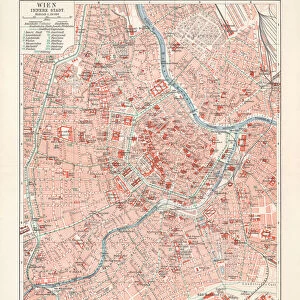
Framed Print : Map of Wilhelmshaven, Lower Saxony, Germany, wood engraving, published 1897


![]()
Framed Photos From Fine Art Storehouse
Map of Wilhelmshaven, Lower Saxony, Germany, wood engraving, published 1897
Historical city map of Wilhelmshaven, Lower Saxony, Germany. Wood engraving, published in 1897
Unleash your creativity and transform your space into a visual masterpiece!
ZU_09
Media ID 19860053
12"x10" Modern Frame
Step back in time with our exquisite Framed Print of "Map of Wilhelmshaven, Lower Saxony, Germany" by ZU_09 from our Fine Art Storehouse. This beautiful wood engraving, published in 1897, showcases the historical city layout of Wilhelmshaven with intricate detail. A must-have for history enthusiasts and those with a passion for classic cartography, this framed print adds a touch of timeless elegance to any room in your home or office.
10x8 Print in an MDF Wooden Frame with 180 gsm Satin Finish Paper. Glazed using shatter proof thin plexi glass. Frame thickness is 1 inch and depth 0.75 inch. Fluted cardboard backing held with clips. Supplied ready to hang with sawtooth hanger and rubber bumpers. Spot clean with a damp cloth. Packaged foam wrapped in a card.
Contemporary Framed and Mounted Prints - Professionally Made and Ready to Hang
Estimated Image Size (if not cropped) is 25.4cm x 25.4cm (10" x 10")
Estimated Product Size is 30.5cm x 25.4cm (12" x 10")
These are individually made so all sizes are approximate
Artwork printed orientated as per the preview above, with landscape (horizontal) or portrait (vertical) orientation to match the source image.
FEATURES IN THESE COLLECTIONS
> Europe
> Germany
> Lower Saxony
> Maps and Charts
> Early Maps
> Maps and Charts
> Related Images
EDITORS COMMENTS
This black and white wood engraving from 1897 takes us back in time to the historical city of Wilhelmshaven, nestled in the picturesque region of Lower Saxony, Germany. The intricate details of this map provide a fascinating glimpse into the layout and architecture of the city over a century ago. As we observe this print, our eyes are drawn to the fine lines that meticulously trace each street and building, showcasing Wilhelmshaven's urban landscape with great precision. The delicate shading adds depth and texture to the image, allowing us to envision what life was like during that era. Wilhelmshaven's rich history as an important naval base is evident in this artwork. From its strategic location on Germany's North Sea coast, it served as a crucial hub for maritime activities throughout centuries past. This map offers insight into how Wilhelmshaven evolved as a bustling port town at the turn of the 19th century. The artist behind this remarkable piece, ZU_09, has skillfully captured not only geographical accuracy but also an artistic interpretation that enhances our appreciation for both cartography and history. Whether you have personal ties to Wilhelmshaven or simply admire vintage maps, this wood engraving serves as a timeless reminder of bygone days when horse-drawn carriages traversed these streets and sailors embarked on voyages across distant seas. Displaying this print proudly would undoubtedly spark conversations about local heritage or ignite curiosity about how cities transform over time. It stands as both an exquisite work of art and
MADE IN THE USA
Safe Shipping with 30 Day Money Back Guarantee
FREE PERSONALISATION*
We are proud to offer a range of customisation features including Personalised Captions, Color Filters and Picture Zoom Tools
SECURE PAYMENTS
We happily accept a wide range of payment options so you can pay for the things you need in the way that is most convenient for you
* Options may vary by product and licensing agreement. Zoomed Pictures can be adjusted in the Basket.