Framed Print > Europe > France > Canton > Landes
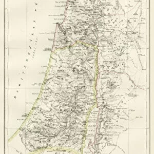
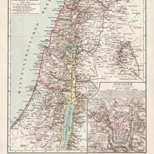
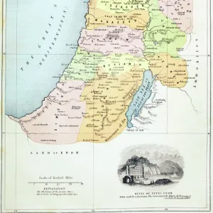
Framed Print : Map showing the mountain ranges of Palestine


![]()
Framed Photos From Fine Art Storehouse
Map showing the mountain ranges of Palestine
Vintage engraving of Map showing the mountain ranges of Palestine, 19th Century
Unleash your creativity and transform your space into a visual masterpiece!
duncan1890
Media ID 14719385
© This content is subject to copyright
Asia Minor Asia Pac Equipment Ground Historical Geopolitical Location Historical Palestine Israel Judea Land Land Feature Middle East Natural Phenomenon Navigational Equipment Palestine Retro Styles Supplies
12"x10" Modern Frame
Add a touch of history to your space with our Framed Print of "Map showing the mountain ranges of Palestine" by duncan1890 from our Media Storehouse Fine Art collection. This vintage engraving, hailing from the 19th Century, beautifully captures the intricacies of the mountain ranges in Palestine. Each print is meticulously framed to preserve its antique charm, making it a unique and captivating addition to any room. Elevate your decor and transport yourself back in time with this stunning piece of historical art.
10x8 Print in an MDF Wooden Frame with 180 gsm Satin Finish Paper. Glazed using shatter proof thin plexi glass. Frame thickness is 1 inch and depth 0.75 inch. Fluted cardboard backing held with clips. Supplied ready to hang with sawtooth hanger and rubber bumpers. Spot clean with a damp cloth. Packaged foam wrapped in a card.
Contemporary Framed and Mounted Prints - Professionally Made and Ready to Hang
Estimated Image Size (if not cropped) is 25.4cm x 25.4cm (10" x 10")
Estimated Product Size is 25.4cm x 30.5cm (10" x 12")
These are individually made so all sizes are approximate
Artwork printed orientated as per the preview above, with landscape (horizontal) or portrait (vertical) orientation to match the source image.
FEATURES IN THESE COLLECTIONS
> Asia
> Israel
> Related Images
> Asia
> Palestine
> Related Images
> Europe
> France
> Canton
> Landes
> Maps and Charts
> Early Maps
> Maps and Charts
> Related Images
EDITORS COMMENTS
This vintage engraving takes us back to the 19th century, offering a glimpse into the historical geopolitical location of Palestine. The print showcases a meticulously detailed map that highlights the magnificent mountain ranges of this ancient land. With its old-fashioned charm and woodcut style, it exudes an air of nostalgia and authenticity. The illustration transports us to a time when cartography was both an art form and a scientific endeavor. It is evident that great care was taken in depicting every land feature, as well as providing accurate navigational equipment for explorers of that era. As we study this piece, we are reminded of the rich history associated with Palestine – from biblical stories set in Judea to its significance within Asia Minor. The mountain ranges depicted on this map stand tall as natural phenomena, shaping the landscape and influencing life in these regions throughout centuries. Duncan1890's print captures not only the beauty but also the essence of historical Palestine. Its antique allure invites us to appreciate how far our understanding has come since those early days of exploration and mapping techniques. This artwork serves as a reminder that even though time may have passed, there is always value in revisiting the past through artistic interpretations like this one.
MADE IN THE USA
Safe Shipping with 30 Day Money Back Guarantee
FREE PERSONALISATION*
We are proud to offer a range of customisation features including Personalised Captions, Color Filters and Picture Zoom Tools
SECURE PAYMENTS
We happily accept a wide range of payment options so you can pay for the things you need in the way that is most convenient for you
* Options may vary by product and licensing agreement. Zoomed Pictures can be adjusted in the Basket.