Framed Print > North America > United States of America > New York > Related Images
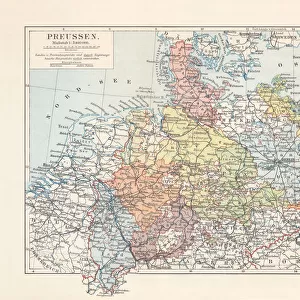
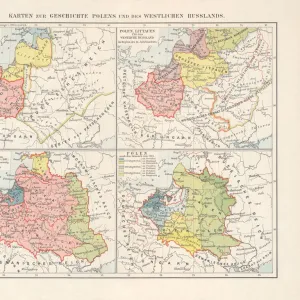
Framed Print : Map of Prussia 1883


![]()
Framed Photos From Fine Art Storehouse
Map of Prussia 1883
Encyclopedia Britannica 9th Edition New York Samuel L. Hall 1883 Vol XX
Unleash your creativity and transform your space into a visual masterpiece!
THEPALMER
Media ID 14756758
© This content is subject to copyright
12"x10" Modern Frame
Step back in time with our exquisite Framed Print of "Map of Prussia 1883" by THEPALMER from the Fine Art Storehouse at Media Storehouse. This captivating piece is taken from the 9th Edition of Encyclopedia Britannica published in New York by Samuel L. Hall in 1883. The intricate details of this antique map showcase the political boundaries of Prussia during that era, making it a fascinating addition to your home or office. Bring history into your space with this beautifully framed and preserved print, perfect for history enthusiasts, cartography lovers, or anyone seeking to add a touch of vintage charm to their decor.
10x8 Print in an MDF Wooden Frame with 180 gsm Satin Finish Paper. Glazed using shatter proof thin plexi glass. Frame thickness is 1 inch and depth 0.75 inch. Fluted cardboard backing held with clips. Supplied ready to hang with sawtooth hanger and rubber bumpers. Spot clean with a damp cloth. Packaged foam wrapped in a card.
Contemporary Framed and Mounted Prints - Professionally Made and Ready to Hang
Estimated Image Size (if not cropped) is 25.4cm x 25.4cm (10" x 10")
Estimated Product Size is 25.4cm x 30.5cm (10" x 12")
These are individually made so all sizes are approximate
Artwork printed orientated as per the preview above, with landscape (horizontal) or portrait (vertical) orientation to match the source image.
FEATURES IN THESE COLLECTIONS
> Fine Art Storehouse
> Map
> Historical Maps
> North America
> United States of America
> New York
> Related Images
EDITORS COMMENTS
This print showcases a historical treasure, the "Map of Prussia 1883" sourced from the esteemed Encyclopedia Britannica 9th Edition. A true testament to the artistry and precision of cartography, this piece takes us back in time to explore the vast territories of Prussia during its peak in the late 19th century. The intricate details and meticulous craftsmanship evident in every inch of this map are a testament to the dedication and expertise of its creator. The rich hues and fine lines beautifully capture not only geographical boundaries but also provide glimpses into an era long gone. As we gaze upon this remarkable work, we can almost feel ourselves transported to bustling cities, serene countryside landscapes, and majestic castles that once dotted Prussian lands. Printed with utmost care by THEPALMER at Fine Art Storehouse, this stunning reproduction allows history enthusiasts, scholars, or anyone with an appreciation for vintage aesthetics to own a piece of Prussian heritage. Whether displayed on office walls or cherished within personal collections, this print serves as both an educational tool and a visual delight. Embrace the opportunity to immerse yourself in history through this exceptional artwork – let it ignite your curiosity about past civilizations while adding elegance and sophistication to any space it graces.
MADE IN THE USA
Safe Shipping with 30 Day Money Back Guarantee
FREE PERSONALISATION*
We are proud to offer a range of customisation features including Personalised Captions, Color Filters and Picture Zoom Tools
SECURE PAYMENTS
We happily accept a wide range of payment options so you can pay for the things you need in the way that is most convenient for you
* Options may vary by product and licensing agreement. Zoomed Pictures can be adjusted in the Basket.