Framed Print > Asia > Palestine > Maps
Framed Print : Map of Palestine 1900


![]()
Framed Photos from Fine Art Storehouse
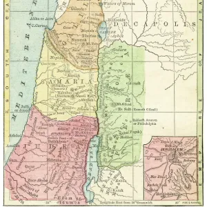
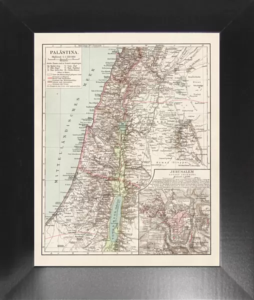
Map of Palestine 1900
Meyers hand-Atlas Leipzig und Wien Verlag des Bibliographischen Instituts 1900
Unleash your creativity and transform your space into a visual masterpiece!
THEPALMER
Media ID 18106877
© 2014 Roberto Adrian Photography
12"x10" Modern Frame
Discover the historical depth of the past with our exquisite framed print of "Map of Palestine 1900" by THEPALMER from the Fine Art Storehouse at Media Storehouse. This captivating piece is taken from the renowned Meyers Hand-Atlas published by the Bibliographisches Institut in Leipzig and Wien in 1900. The intricate details and vibrant colors bring the history of Palestine to life, making it a stunning addition to any home or office decor. Delve into the rich tapestry of history and enhance your space with this beautiful framed print.
10x8 Print in an MDF Wooden Frame with 180 gsm Satin Finish Paper. Glazed using shatter proof thin plexi glass. Frame thickness is 1 inch and depth 0.75 inch. Fluted cardboard backing held with clips. Supplied ready to hang with sawtooth hanger and rubber bumpers. Spot clean with a damp cloth. Packaged foam wrapped in a card.
Contemporary Framed and Mounted Prints - Professionally Made and Ready to Hang
Estimated Image Size (if not cropped) is 25.4cm x 25.4cm (10" x 10")
Estimated Product Size is 25.4cm x 30.5cm (10" x 12")
These are individually made so all sizes are approximate
Artwork printed orientated as per the preview above, with landscape (horizontal) or portrait (vertical) orientation to match the source image.
FEATURES IN THESE COLLECTIONS
> Fine Art Storehouse
> Map
> Historical Maps
> Asia
> Palestine
> Related Images
EDITORS COMMENTS
In this print titled "Map of Palestine 1900". THEPALMER takes us on a historical journey back to the turn of the century. The image showcases a meticulously detailed map from Meyers hand-Atlas Leipzig und Wien Verlag des Bibliographischen Instituts, published in 1900. The map itself is a testament to cartographic artistry, with intricate lines and delicate shading that bring to life the geography of Palestine as it was known at that time. It serves as a visual window into an era when borders were different, and political landscapes were yet to be reshaped. As we gaze upon this vintage masterpiece, our imagination transports us to an era where exploration and discovery were paramount. We can almost feel the excitement of early explorers who embarked on perilous journeys through uncharted territories, documenting their findings for future generations. Beyond its artistic allure, this photograph print holds immense historical significance. It offers a glimpse into how perceptions of land ownership have evolved over time while reminding us of the rich cultural heritage embedded within these ancient lands. "The Map of Palestine 1900" invites viewers to reflect upon history's impact on our present reality and encourages dialogue about geopolitical changes throughout time. As we contemplate this remarkable piece by THEPALMER, let it serve as a reminder that every map tells a story - one that intertwines human experiences with the ever-changing dynamics of our world.
MADE IN THE USA
Safe Shipping with 30 Day Money Back Guarantee
FREE PERSONALISATION*
We are proud to offer a range of customisation features including Personalised Captions, Color Filters and Picture Zoom Tools
SECURE PAYMENTS
We happily accept a wide range of payment options so you can pay for the things you need in the way that is most convenient for you
* Options may vary by product and licensing agreement. Zoomed Pictures can be adjusted in the Cart.