Framed Print > Asia > India > Maps
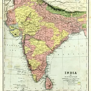
Framed Print : Map of India and Central Asia 1896


![]()
Framed Photos from Fine Art Storehouse
Map of India and Central Asia 1896
Andres Allgemeiner Handatlas - Bielefeld und Leipzig 1896
Unleash your creativity and transform your space into a visual masterpiece!
THEPALMER
Media ID 18356839
12"x10" Modern Frame
Step back in time with our exquisite Framed Print of "Map of India and Central Asia 1896" by THEPALMER from the Media Storehouse Fine Art Storehouse collection. This captivating vintage map, published in Andres Allgemeiner Handatlas - Bielefeld und Leipzig 1896, offers a fascinating glimpse into the historical geography of the region. The intricate details and rich colors are brought to life in this beautifully framed piece, making it a stunning addition to any home or office. Travel back in time and add a touch of history to your space with this unique and intriguing Framed Print.
10x8 Print in an MDF Wooden Frame with 180 gsm Satin Finish Paper. Glazed using shatter proof thin plexi glass. Frame thickness is 1 inch and depth 0.75 inch. Fluted cardboard backing held with clips. Supplied ready to hang with sawtooth hanger and rubber bumpers. Spot clean with a damp cloth. Packaged foam wrapped in a card.
Contemporary Framed and Mounted Prints - Professionally Made and Ready to Hang
Estimated Image Size (if not cropped) is 25.4cm x 25.4cm (10" x 10")
Estimated Product Size is 25.4cm x 30.5cm (10" x 12")
These are individually made so all sizes are approximate
Artwork printed orientated as per the preview above, with landscape (horizontal) or portrait (vertical) orientation to match the source image.
FEATURES IN THESE COLLECTIONS
> Fine Art Storehouse
> Map
> Historical Maps
> Asia
> India
> Related Images
> Asia
> Related Images
> Maps and Charts
> India
> Maps and Charts
> Related Images
EDITORS COMMENTS
This print showcases a vintage map titled "Map of India and Central Asia 1896" sourced from Andres Allgemeiner Handatlas - Bielefeld und Leipzig 1896. A true gem for history enthusiasts, this piece takes us back to the late 19th century, offering a glimpse into the intricate cartographic knowledge of that era. The map itself is a testament to the artistry and precision involved in creating such detailed representations before modern technology took over. With its delicate lines and meticulous labeling, it invites viewers on an exploratory journey through the vast territories of India and Central Asia as they existed more than a century ago. As we delve into this visual treasure trove, we can trace ancient trade routes, discover forgotten cities, and marvel at the diverse topography that defines these regions. From the majestic peaks of the Himalayas to the sprawling deserts of Rajasthan, every contour tells a story waiting to be unraveled. Beyond its historical significance lies an aesthetic appeal that adds charm to any space it graces. The warm sepia tones evoke nostalgia while enhancing its antique allure. Whether displayed in homes or offices, this print by THEPALMER from Fine Art Storehouse serves as both an educational tool and a conversation starter. Allow yourself to get lost in time with this remarkable artwork – let your imagination wander across borders and immerse yourself in an era long gone but forever preserved within this stunning depiction of India and Central Asia's past.
MADE IN THE USA
Safe Shipping with 30 Day Money Back Guarantee
FREE PERSONALISATION*
We are proud to offer a range of customisation features including Personalised Captions, Color Filters and Picture Zoom Tools
SECURE PAYMENTS
We happily accept a wide range of payment options so you can pay for the things you need in the way that is most convenient for you
* Options may vary by product and licensing agreement. Zoomed Pictures can be adjusted in the Cart.