Framed Print > Europe > Republic of Ireland > Maps
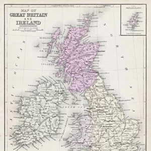
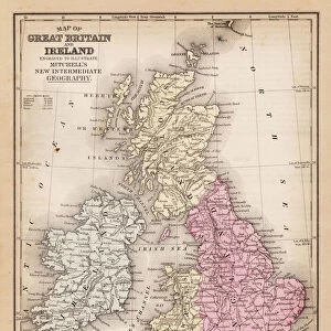
Framed Print : Map of Great Britain and Ireland 1896


![]()
Framed Photos From Fine Art Storehouse
Map of Great Britain and Ireland 1896
Andres Allgemeiner Handatlas - Bielefeld und Leipzig 1896
Unleash your creativity and transform your space into a visual masterpiece!
THEPALMER
Media ID 18357075
12"x10" Modern Frame
Step back in time with our exquisite Framed Print of the "Map of Great Britain and Ireland 1896" by THEPALMER from our Media Storehouse Fine Art collection. This antique map, published by Andres & Companie in Bielefeld and Leipzig, showcases intricate details of the British Isles during a fascinating historical era. The vintage design and superior craftsmanship of this framed print will add an authentic, timeless touch to any room in your home or office. Elevate your decor and transport yourself back to the late 19th century with this captivating piece of art.
10x8 Print in an MDF Wooden Frame with 180 gsm Satin Finish Paper. Glazed using shatter proof thin plexi glass. Frame thickness is 1 inch and depth 0.75 inch. Fluted cardboard backing held with clips. Supplied ready to hang with sawtooth hanger and rubber bumpers. Spot clean with a damp cloth. Packaged foam wrapped in a card.
Contemporary Framed and Mounted Prints - Professionally Made and Ready to Hang
Estimated Image Size (if not cropped) is 25.4cm x 25.4cm (10" x 10")
Estimated Product Size is 25.4cm x 30.5cm (10" x 12")
These are individually made so all sizes are approximate
Artwork printed orientated as per the preview above, with landscape (horizontal) or portrait (vertical) orientation to match the source image.
FEATURES IN THESE COLLECTIONS
> Fine Art Storehouse
> Map
> Historical Maps
> Europe
> Republic of Ireland
> Maps
> Maps and Charts
> Related Images
EDITORS COMMENTS
This print showcases a remarkable piece of history, the "Map of Great Britain and Ireland 1896" from Andres Allgemeiner Handatlas - Bielefeld und Leipzig 1896. With exquisite detail and precision, this vintage map takes us back to an era where cartography was both an art form and a scientific endeavor. The Map of Great Britain and Ireland in 1896 offers a fascinating glimpse into the geopolitical landscape of that time. It beautifully illustrates the intricate network of cities, towns, rivers, mountains, and coastlines that define these two nations. Each line meticulously drawn represents not only geographical boundaries but also cultural connections that have shaped their shared histories. As we delve into this historical artifact captured by THEPALMER for Fine Art Storehouse, we are transported to an age when exploration was at its peak. The delicate hues used on this print add a touch of nostalgia while enhancing our appreciation for the craftsmanship involved in creating such detailed maps before modern technology took over. Whether you are an avid historian or simply captivated by the beauty found in old-world cartography, this print is sure to spark curiosity and ignite conversations about how our world has evolved over time. Display it proudly as a testament to human ingenuity and as a reminder that even in today's digital age, there is still something magical about holding tangible pieces of our past within our hands.
MADE IN THE USA
Safe Shipping with 30 Day Money Back Guarantee
FREE PERSONALISATION*
We are proud to offer a range of customisation features including Personalised Captions, Color Filters and Picture Zoom Tools
SECURE PAYMENTS
We happily accept a wide range of payment options so you can pay for the things you need in the way that is most convenient for you
* Options may vary by product and licensing agreement. Zoomed Pictures can be adjusted in the Basket.