Framed Print > Asia > Myanmar > Maps
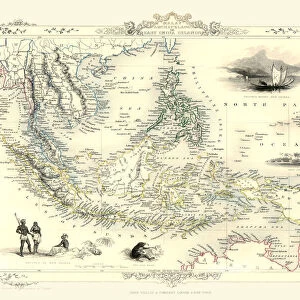
Framed Print : Map of Burma and Malay Peninsula 1896


![]()
Framed Photos from Fine Art Storehouse
Map of Burma and Malay Peninsula 1896
Andres Allgemeiner Handatlas - Bielefeld und Leipzig 1896
Unleash your creativity and transform your space into a visual masterpiece!
THEPALMER
Media ID 18357085
18"x14" Modern Frame
Step back in time with our exquisite framed print of the "Map of Burma and Malay Peninsula 1896" by THEPALMER from our Media Storehouse collection. This fine art print, taken from Andres Allgemeiner Handatlas published in Bielefeld and Leipzig, offers a fascinating glimpse into historical cartography. The intricate details of the map, which highlights the political boundaries and geographical features of Burma and the Malay Peninsula during that era, are sure to captivate history buffs and cartography enthusiasts alike. Framed in a elegant and timeless frame, this print adds a touch of sophistication and intrigue to any room. Order yours today and bring a piece of historical cartography into your home or office.
16x12 Print in an MDF Wooden Frame with 180 gsm Satin Finish Paper. Glazed using shatter proof thin plexiglass. Frame thickness is 1 inch and depth 0.75 inch. Fluted cardboard backing held with clips. Supplied ready to hang with sawtooth hanger and rubber bumpers. Spot clean with a damp cloth. Packaged foam wrapped in a card.
Contemporary Framed and Mounted Prints - Professionally Made and Ready to Hang
Estimated Image Size (if not cropped) is 35.6cm x 40.6cm (14" x 16")
Estimated Product Size is 35.6cm x 45.7cm (14" x 18")
These are individually made so all sizes are approximate
Artwork printed orientated as per the preview above, with portrait (vertical) orientation to match the source image.
FEATURES IN THESE COLLECTIONS
> Fine Art Storehouse
> Map
> Historical Maps
> Asia
> Myanmar
> Related Images
> Maps and Charts
> Related Images
EDITORS COMMENTS
This print showcases a remarkable piece of cartographic history - the "Map of Burma and Malay Peninsula 1896". Taken from Andres Allgemeiner Handatlas, published in Bielefeld und Leipzig in 1896, this exquisite map offers a glimpse into the past, allowing us to explore the intricate details and geographical nuances of these Southeast Asian regions. The map's rich color palette beautifully highlights various topographical features, rivers, cities, and borders. It is evident that great care was taken to meticulously depict every aspect of this diverse landscape. From the lush forests to the winding waterways snaking through vast plains, one can almost feel transported back in time. As we delve deeper into its intricacies, it becomes apparent that this map not only serves as a navigational tool but also provides valuable insights into historical events and cultural influences that shaped these lands over centuries. The names of towns and villages evoke curiosity about their origins while reminding us of the vibrant tapestry woven by different ethnic groups inhabiting these areas. "The Map of Burma and Malay Peninsula 1896" is more than just an artistic representation; it encapsulates a moment frozen in time when explorers sought to unravel mysteries hidden within uncharted territories. With each glance at this mesmerizing print by THEPALMER from Fine Art Storehouse, we are reminded of our shared human fascination with discovery and our innate desire to understand the world around us.
MADE IN THE USA
Safe Shipping with 30 Day Money Back Guarantee
FREE PERSONALISATION*
We are proud to offer a range of customisation features including Personalised Captions, Color Filters and Picture Zoom Tools
SECURE PAYMENTS
We happily accept a wide range of payment options so you can pay for the things you need in the way that is most convenient for you
* Options may vary by product and licensing agreement. Zoomed Pictures can be adjusted in the Cart.