Framed Print > North America > United States of America > New York > New York > Maps
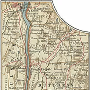
Framed Print : Map of the Hudson River, New York, c.1900 (engraving)
")
")
![]()
Framed Photos From Fine Art Finder
Map of the Hudson River, New York, c.1900 (engraving)
533427 Map of the Hudson River, New York, c.1900 (engraving); (add.info.: Map of Hudson River, New York, from Yonkers to Kingston, circa 1902, from the 10th edition of Encyclopaedia Britannica.); Encyclopaedia Britannica/UIG
Media ID 38139012
© Encyclopaedia Britannica/UIG / Bridgeman Images
1902 19th Century Style Boundary Cut Out Guidance Hudson River Illustration Technique Navigational Equipment New York State Old Fashioned Panoramic Part Of Physical Geography The Past Western Script White Background
18"x14" Modern Frame
Bring a touch of vintage charm to your home with this beautifully detailed framed print of the Map of the Hudson River, New York, circa 1900. Perfect for history buffs and lovers of classic decor alike.
16x12 Print in an MDF Wooden Frame with 180 gsm Satin Finish Paper. Glazed using shatter proof thin plexiglass. Frame thickness is 1 inch and depth 0.75 inch. Fluted cardboard backing held with clips. Supplied ready to hang with sawtooth hanger and rubber bumpers. Spot clean with a damp cloth. Packaged foam wrapped in a card.
Contemporary Framed and Mounted Prints - Professionally Made and Ready to Hang
Estimated Image Size (if not cropped) is 35.6cm x 40.6cm (14" x 16")
Estimated Product Size is 35.6cm x 45.7cm (14" x 18")
These are individually made so all sizes are approximate
Artwork printed orientated as per the preview above, with portrait (vertical) orientation to match the source image.
FEATURES IN THESE COLLECTIONS
> Maps and Charts
> Related Images
> North America
> United States of America
> Maps
> North America
> United States of America
> New York
> New York
> Maps
> North America
> United States of America
> New York
> New York
> Related Images
> North America
> United States of America
> New York
> Related Images
> North America
> United States of America
> New York
> Yonkers
EDITORS COMMENTS
This stunning engraving of a map of the Hudson River, New York, circa 1900, captures the intricate details and historical significance of this iconic waterway. From Yonkers to Kingston, every bend and curve is meticulously depicted in this 19th-century style cartography.
The boundaries of the river are clearly marked in Western script, showcasing the navigational importance of this vital transportation route. The white background highlights the panoramic view of the river, allowing viewers to immerse themselves in its beauty and grandeur.
As a part of physical geography, this old-fashioned map serves as a valuable tool for exploration and guidance along the Hudson River. Its vintage charm evokes a sense of nostalgia for a bygone era when maps were essential for travel and discovery.
This engraving is not just a piece of art but also a historical document that reflects the past glory of New York State. With no people in sight, it stands as a testament to the enduring legacy of this great American river.
Whether you're an avid collector or simply appreciate fine craftsmanship, this print is sure to add character and sophistication to any space. Let yourself be transported back in time with this exquisite illustration technique from Bridgeman Images' Fine Art Finder collection.
MADE IN THE USA
Safe Shipping with 30 Day Money Back Guarantee
FREE PERSONALISATION*
We are proud to offer a range of customisation features including Personalised Captions, Color Filters and Picture Zoom Tools
SECURE PAYMENTS
We happily accept a wide range of payment options so you can pay for the things you need in the way that is most convenient for you
* Options may vary by product and licensing agreement. Zoomed Pictures can be adjusted in the Basket.