Framed Print > Africa > Related Images
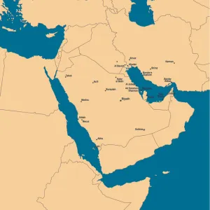
Framed Print : Partial Map of the Middle East showing the Red Sea, Persian Gulf and Horn of Africa in the 1890s


![]()
Framed Photos From Fine Art Finder
Partial Map of the Middle East showing the Red Sea, Persian Gulf and Horn of Africa in the 1890s
KW287951 Partial Map of the Middle East showing the Red Sea, Persian Gulf and Horn of Africa in the 1890s, from The Citizens Atlas of the World, published in London, c.1899 (colour litho) by English School, (19th century); Private Collection; Ken Welsh; English, out of copyright
Media ID 12802707
© www.bridgemanimages.com
Iran Levant Nubia Persia Gulf Of Aden
18"x14" Modern Frame
Step back in time with our stunning Framed Print from Media Storehouse, featuring an intriguing Partial Map of the Middle East from the late 1890s. This captivating vintage map, sourced from Bridgeman Images through Fine Art Finder, showcases the Red Sea, Persian Gulf, and Horn of Africa in exquisite detail. With its rich historical context, this map is a beautiful addition to any home or office, transporting you to a bygone era. Order now and let this piece of history tell its story in your space.
16x12 Print in an MDF Wooden Frame with 180 gsm Satin Finish Paper. Glazed using shatter proof thin plexiglass. Frame thickness is 1 inch and depth 0.75 inch. Fluted cardboard backing held with clips. Supplied ready to hang with sawtooth hanger and rubber bumpers. Spot clean with a damp cloth. Packaged foam wrapped in a card.
Contemporary Framed and Mounted Prints - Professionally Made and Ready to Hang
Estimated Image Size (if not cropped) is 35.6cm x 40.6cm (14" x 16")
Estimated Product Size is 35.6cm x 45.7cm (14" x 18")
These are individually made so all sizes are approximate
Artwork printed orientated as per the preview above, with portrait (vertical) orientation to match the source image.
FEATURES IN THESE COLLECTIONS
> Africa
> Related Images
> Europe
> United Kingdom
> England
> London
> Related Images
EDITORS COMMENTS
This print showcases a partial map of the Middle East, capturing the essence of the region in the 1890s. The intricate details and vibrant colors bring to life the Red Sea, Persian Gulf, and Horn of Africa with remarkable accuracy. Published in London as part of "The Citizens Atlas of the World" in 1899, this piece is a testament to both historical cartography and artistic craftsmanship. As we delve into this snapshot from history, our eyes are drawn to key landmarks such as the Gulf of Aden, Persia (modern-day Iran), Nubia (present-day Sudan), Levant (including parts of modern-day Syria and Lebanon). Each element on this map tells a story about trade routes, cultural exchanges, and geopolitical dynamics that shaped this diverse region during that era. With its rich hues and meticulous attention to detail, this print offers us an opportunity to explore not only geographical boundaries but also historical narratives. It serves as a visual time capsule transporting us back over a century ago when empires rose and fell against breathtaking landscapes. Displayed here for educational purposes by Fine Art Finder's collection from Ken Welsh's private collection; it reminds us how art can be used as an invaluable tool for understanding our past. Let your imagination wander through these ancient lands while appreciating their beauty through this exquisite piece.
MADE IN THE USA
Safe Shipping with 30 Day Money Back Guarantee
FREE PERSONALISATION*
We are proud to offer a range of customisation features including Personalised Captions, Color Filters and Picture Zoom Tools
SECURE PAYMENTS
We happily accept a wide range of payment options so you can pay for the things you need in the way that is most convenient for you
* Options may vary by product and licensing agreement. Zoomed Pictures can be adjusted in the Basket.