Framed Print > Europe > Italy > Liguria > Savona
Framed Print : Map of Italy from Monaco in France to Genoa, through the provinces of Imperia de Savona


![]()
Framed Photos From Fine Art Finder
Map of Italy from Monaco in France to Genoa, through the provinces of Imperia de Savona
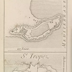
LRI4704752 Map of Italy from Monaco in France to Genoa, through the provinces of Imperia de Savona and Genoa, 1570 (engraving) by Ortelius, Abraham (1527-98); Museo Navale di Pegli, Genoa, Italy; (add.info.: Pedemontanae Vicinorumque Regionum Auctore Iacobo Castaldo Descrip. Geography map of the territory of Italy from Monaco in France to Genes and passing through the provinces of Imperia de Savona and Genoa from " Theatrum Orbis Terrarum" by Abraham Ortelius (Oertel, Ortell or Ortel, 1527-1598), 1570. Genova, Museo Navale); Luisa Ricciarini; Flemish, out of copyright
Media ID 23736386
© Luisa Ricciarini / Bridgeman Images
12"x10" Modern Frame
Discover the rich history and culture of Italy with our exquisite Framed Print of the Map of Italy from Monaco in France to Genoa. This beautiful piece, featuring the intricate and detailed 1570 map by Abraham Ortelius, takes you on a journey through the provinces of Imperia, Savona, and Genoa. Meticulously reproduced from the original held at the Museo Navale di Pegli in Genoa, this Framed Print by Luisa Ricciarini is a stunning addition to any home or office, bringing the beauty of Italian cartography into your space. Perfect for history enthusiasts, travelers, or anyone with a love for Italy, this Framed Print is a timeless treasure to be cherished for generations.
10x8 Print in an MDF Wooden Frame with 180 gsm Satin Finish Paper. Glazed using shatter proof thin plexi glass. Frame thickness is 1 inch and depth 0.75 inch. Fluted cardboard backing held with clips. Supplied ready to hang with sawtooth hanger and rubber bumpers. Spot clean with a damp cloth. Packaged foam wrapped in a card.
Contemporary Framed and Mounted Prints - Professionally Made and Ready to Hang
Estimated Image Size (if not cropped) is 25.4cm x 25.4cm (10" x 10")
Estimated Product Size is 30.5cm x 25.4cm (12" x 10")
These are individually made so all sizes are approximate
Artwork printed orientated as per the preview above, with landscape (horizontal) or portrait (vertical) orientation to match the source image.
FEATURES IN THESE COLLECTIONS
> Arts
> Artists
> O
> Abraham Ortelius
> Europe
> Italy
> Liguria
> Genoa
> Europe
> Italy
> Liguria
> Imperia
> Europe
> Italy
> Liguria
> Savona
> Europe
> Monaco
> Related Images
> Maps and Charts
> Abraham Ortelius
EDITORS COMMENTS
This print showcases a remarkable map of Italy, dating back to 1570. Created by the renowned cartographer Abraham Ortelius, this engraving offers a detailed depiction of the territory from Monaco in France to Genoa, traversing through the provinces of Imperia de Savona and Genoa. The map is currently housed at the Museo Navale di Pegli in Genoa, Italy. Ortelius' expertise shines through as he meticulously captures the geographical features and boundaries of each region. From mountain ranges to rivers and coastlines, every element is intricately illustrated with precision and accuracy. This masterpiece provides an invaluable historical record of Italy during that era. The artist behind this stunning print is Luisa Ricciarini, who skillfully captured every intricate detail using her camera lens. Through her work, she invites us to delve into history and immerse ourselves in the rich cultural heritage preserved within this ancient map. As we gaze upon this image, we are transported back in time - imagining traders navigating these very routes or explorers embarking on new adventures across these lands. It serves as a reminder of how maps have played an essential role throughout history - not only guiding our physical journeys but also shaping our understanding of different regions and cultures. Luisa Ricciarini's photograph beautifully encapsulates both the artistic mastery of Ortelius' original creation and its enduring significance as a testament to human curiosity about our world.
MADE IN THE USA
Safe Shipping with 30 Day Money Back Guarantee
FREE PERSONALISATION*
We are proud to offer a range of customisation features including Personalised Captions, Color Filters and Picture Zoom Tools
SECURE PAYMENTS
We happily accept a wide range of payment options so you can pay for the things you need in the way that is most convenient for you
* Options may vary by product and licensing agreement. Zoomed Pictures can be adjusted in the Basket.