Framed Print > Maps and Charts > World
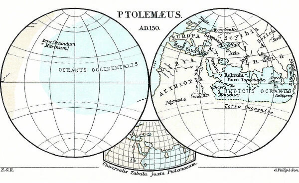
Framed Print : Ptolemaeus Map A.D. 150. From the book Life of Christopher Columbus by Clements R. Markham published 1892
![]()

Framed Photos From Fine Art Finder
Ptolemaeus Map A.D. 150. From the book Life of Christopher Columbus by Clements R. Markham published 1892
2915322 Ptolemaeus Map A.D. 150. From the book Life of Christopher Columbus by Clements R. Markham published 1892.; Photo © Hilary Morgan
Media ID 38249528
© © Hilary Morgan / Bridgeman Images
Chart Circular Geographical Globe Mapmaking Planisphere Ptolemaeus Ptolomy
18"x14" Modern Frame
Explore the rich history of Christopher Columbus with this stunning framed print featuring a Ptolemaeus Map from A.D. 150. Perfect for adding a touch of vintage charm to any space.
16x12 Print in an MDF Wooden Frame with 180 gsm Satin Finish Paper. Glazed using shatter proof thin plexiglass. Frame thickness is 1 inch and depth 0.75 inch. Fluted cardboard backing held with clips. Supplied ready to hang with sawtooth hanger and rubber bumpers. Spot clean with a damp cloth. Packaged foam wrapped in a card.
Contemporary Framed and Mounted Prints - Professionally Made and Ready to Hang
Estimated Image Size (if not cropped) is 40.6cm x 35.6cm (16" x 14")
Estimated Product Size is 45.7cm x 35.6cm (18" x 14")
These are individually made so all sizes are approximate
Artwork printed orientated as per the preview above, with landscape (horizontal) orientation to match the source image.
FEATURES IN THESE COLLECTIONS
> Fine Art Finder
> Artists
> Raymond de la Neziere
> Maps and Charts
> Related Images
> Maps and Charts
> World
EDITORS COMMENTS
This stunning print of Ptolemaeus Map A.D. 150, taken from the book "Life of Christopher Columbus" by Clements R. Markham and published in 1892, offers a fascinating glimpse into the world of cartography during that time period. The map, created by the renowned Greek geographer Ptolemy, showcases intricate details and precise measurements that were revolutionary for its era.
The circular design of this ancient map is both visually striking and historically significant, as it represents one of the earliest known attempts to chart the entire known world. With its carefully drawn lines and symbols denoting various geographical features, this planisphere serves as a testament to humanity's enduring fascination with exploration and discovery.
As we gaze upon this remarkable piece of mapmaking artistry, we are transported back in time to an age when sailors relied on such charts to navigate treacherous waters and explore distant lands. The meticulous craftsmanship displayed in Ptolemy's work reminds us of the ingenuity and skill possessed by those early pioneers who dared to venture beyond the boundaries of their known world.
In studying this ancient map, we gain a deeper appreciation for the complexities of geography and the boundless curiosity that has driven mankind to explore every corner of our planet. It serves as a reminder that while our understanding of the world may have evolved over time, our thirst for knowledge remains constant.
MADE IN THE USA
Safe Shipping with 30 Day Money Back Guarantee
FREE PERSONALISATION*
We are proud to offer a range of customisation features including Personalised Captions, Color Filters and Picture Zoom Tools
SECURE PAYMENTS
We happily accept a wide range of payment options so you can pay for the things you need in the way that is most convenient for you
* Options may vary by product and licensing agreement. Zoomed Pictures can be adjusted in the Basket.


