Framed Print > Europe > United Kingdom > Wales > Related Images
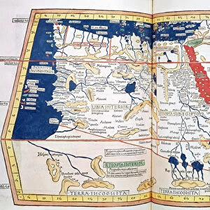
Framed Print : Tabula Prima Europa, from Geographie opus novissima traductione e Grecorum archetypis


![]()
Framed Photos From Fine Art Finder
Tabula Prima Europa, from Geographie opus novissima traductione e Grecorum archetypis
XYC269016 Tabula Prima Europa, from Geographie opus novissima traductione e Grecorum archetypis castigatissime pressum, printed by Johann Scott in 1513 (colour litho) by Ptolemy (Claudius Ptolemaeus of Alexandria)(c.90-168)(after); Yale Center for British Art, Paul Mellon Collection, USA; (add.info.: compiled by Martin Waldseemuller; ); Greek, out of copyright
Media ID 12787335
© www.bridgemanart.com
18"x14" Modern Frame
Introduce a touch of historical elegance to your space with Media Storehouse's Framed Prints featuring the Tabula Prima Europa, a rare and captivating map from the 16th century. Originally printed by Johann Scott in 1513 from the work "Geographie opus novissima traductione e Grecorum archetypis," this stunning map showcases Europe in intricate detail. Each print is meticulously framed to preserve the rich colors and intricacies of the original lithograph, transporting you back in time. Bring history to life in your home or office with this exquisite piece from the Fine Art Finder collection at Media Storehouse.
16x12 Print in an MDF Wooden Frame with 180 gsm Satin Finish Paper. Glazed using shatter proof thin plexiglass. Frame thickness is 1 inch and depth 0.75 inch. Fluted cardboard backing held with clips. Supplied ready to hang with sawtooth hanger and rubber bumpers. Spot clean with a damp cloth. Packaged foam wrapped in a card.
Contemporary Framed and Mounted Prints - Professionally Made and Ready to Hang
Estimated Image Size (if not cropped) is 40.6cm x 35.6cm (16" x 14")
Estimated Product Size is 45.7cm x 35.6cm (18" x 14")
These are individually made so all sizes are approximate
Artwork printed orientated as per the preview above, with landscape (horizontal) orientation to match the source image.
FEATURES IN THESE COLLECTIONS
> Fine Art Finder
> Artists
> P
> Ptolemy (c.90-168)(after) Ptolemy
> Fine Art Finder
> Artists
> Ptolemy (c.90-168)(after)
> Fine Art Finder
> Maps (celestial & Terrestrial)
> Europe
> United Kingdom
> Wales
> Related Images
EDITORS COMMENTS
This print showcases the "Tabula Prima Europa" map, a remarkable piece of cartography from the 16th century. Printed by Johann Scott in 1513, this color lithograph is based on the original work by Ptolemy, a renowned Greek geographer and mathematician. The intricate details of this map transport us back in time to an era when exploration and discovery were at their peak. The map depicts Europe with astonishing accuracy for its time, showcasing countries such as England, Scotland, Ireland, and Wales. It provides a fascinating glimpse into how these regions were perceived during the Roman Empire. Compiled by Martin Waldseemuller, another influential figure in early cartography, this masterpiece represents an amalgamation of ancient knowledge and modern printing techniques. Its inclusion in the Paul Mellon Collection at Yale Center for British Art further emphasizes its significance within art history. As we admire this historic artifact through our contemporary lens, it serves as a reminder of humanity's insatiable curiosity about the world around us. This particular print offers not only aesthetic pleasure but also valuable insights into European geography during a pivotal period in history.
MADE IN THE USA
Safe Shipping with 30 Day Money Back Guarantee
FREE PERSONALISATION*
We are proud to offer a range of customisation features including Personalised Captions, Color Filters and Picture Zoom Tools
SECURE PAYMENTS
We happily accept a wide range of payment options so you can pay for the things you need in the way that is most convenient for you
* Options may vary by product and licensing agreement. Zoomed Pictures can be adjusted in the Basket.