Framed Print > Europe > France > Paris > Related Images
Framed Print : Map of central Europe, 1486 (coloured engraving) (details of 157909)
 (details of 157909)")
 (details of 157909)")

![]()
Framed Photos From Fine Art Finder
Map of central Europe, 1486 (coloured engraving) (details of 157909)
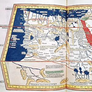
XIR239265 Map of central Europe, 1486 (coloured engraving) (details of 157909) by Ptolemy (Claudius Ptolemaeus of Alexandria)(c.90-168)(after); Bibliotheque Nationale, Paris, France; Greek, out of copyright
Media ID 12769598
© www.bridgemanimages.com
Chart Europa Hungary Mediterranean Dacia Datia
12"x10" Modern Frame
Step back in time with our exquisite Framed Prints from Media Storehouse. This captivating piece showcases a detailed, coloured engraving of a Map of Central Europe, dated back to 1486. The map, attributed to Ptolemy (Claudius Ptolemaeus of Alexandria), is an intriguing glimpse into the cartography of the time. Originally sourced from the Bibliotheque Nationale in Paris, France, this rare and beautiful work is a must-have for history enthusiasts, geography aficionados, and those who appreciate the art of the past. Add a touch of history and sophistication to your home or office space with our expertly crafted Framed Prints.
10x8 Print in an MDF Wooden Frame with 180 gsm Satin Finish Paper. Glazed using shatter proof thin plexi glass. Frame thickness is 1 inch and depth 0.75 inch. Fluted cardboard backing held with clips. Supplied ready to hang with sawtooth hanger and rubber bumpers. Spot clean with a damp cloth. Packaged foam wrapped in a card.
Contemporary Framed and Mounted Prints - Professionally Made and Ready to Hang
Estimated Image Size (if not cropped) is 25.4cm x 25.4cm (10" x 10")
Estimated Product Size is 30.5cm x 25.4cm (12" x 10")
These are individually made so all sizes are approximate
Artwork printed orientated as per the preview above, with landscape (horizontal) or portrait (vertical) orientation to match the source image.
FEATURES IN THESE COLLECTIONS
> Fine Art Finder
> Artists
> P
> Ptolemy (c.90-168)(after) Ptolemy
> Fine Art Finder
> Artists
> Ptolemy (c.90-168)(after)
> Fine Art Finder
> Maps (celestial & Terrestrial)
> Europe
> France
> Paris
> Related Images
> Europe
> Related Images
EDITORS COMMENTS
This print showcases a beautifully detailed "Map of central Europe, 1486" by the renowned ancient geographer Claudius Ptolemy. Created through the technique of coloured engraving, this map offers a glimpse into the world as it was perceived over five centuries ago. The intricate details and vibrant colors bring to life an era when cartography was still in its infancy. The map highlights various regions including Hungary, Dacia, and other parts of Europe surrounding the Mediterranean Sea. It provides valuable insight into how these areas were understood during Ptolemy's time. Displayed in Bibliotheque Nationale in Paris, France, this historical artifact holds immense significance for scholars and enthusiasts alike. Its presence serves as a testament to Ptolemy's enduring legacy and his contributions to our understanding of geography. As we gaze upon this remarkable piece of artistry captured by www. bridgemanimages. com, we are transported back in time to an age where exploration and discovery shaped our perception of the world. This image invites us to appreciate both the beauty inherent in maps as well as their ability to convey knowledge across generations. Whether you are an avid historian or simply captivated by ancient cartography, this stunning print is sure to spark curiosity and ignite your imagination about Central Europe's past.
MADE IN THE USA
Safe Shipping with 30 Day Money Back Guarantee
FREE PERSONALISATION*
We are proud to offer a range of customisation features including Personalised Captions, Color Filters and Picture Zoom Tools
SECURE PAYMENTS
We happily accept a wide range of payment options so you can pay for the things you need in the way that is most convenient for you
* Options may vary by product and licensing agreement. Zoomed Pictures can be adjusted in the Basket.