Framed Print > Animals > Mammals > Cats (Wild) > Lion
Framed Print : The Atlantic coasts of Europe and the Western Mediterranean, from a nautical atlas


![]()
Framed Photos From Fine Art Finder
The Atlantic coasts of Europe and the Western Mediterranean, from a nautical atlas
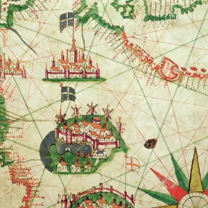
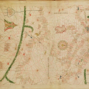
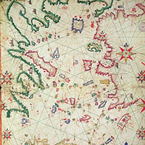
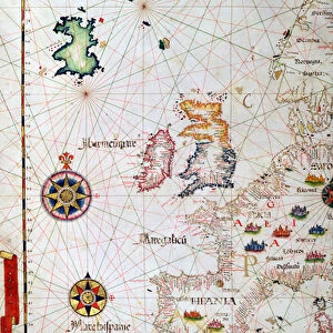
XOT330919 The Atlantic coasts of Europe and the Western Mediterranean, from a nautical atlas, 1651 (ink on vellum) (see also ) by Pietro Giovanni Prunes (fl. 17th Century); 41.6x28 cm; Museo Correr, Venice, Italy; Italian, out of copyright
Media ID 12852575
© www.bridgemanart.com
Balearic Islands Camel Camels Chart Cities Compass Corsica Elephant Iberian Peninsula Mapping Portolan Portugal Sardinia
12"x10" Modern Frame
Add a touch of historical maritime charm to your decor with our Framed Prints from Media Storehouse, featuring the intricately detailed map "The Atlantic coasts of Europe and the Western Mediterranean, from a nautical atlas" by Pietro Giovanni Prunes. Dated back to 1651, this exquisite ink on vellum artwork from Bridgeman Art Library showcases the Atlantic coastlines of Europe and the Western Mediterranean with meticulous accuracy. Each print is carefully framed to preserve its beauty and authenticity, making it an excellent addition to any home or office space. Travel back in time and explore the rich history of cartography with this stunning piece from Fine Art Finder.
10x8 Print in an MDF Wooden Frame with 180 gsm Satin Finish Paper. Glazed using shatter proof thin plexi glass. Frame thickness is 1 inch and depth 0.75 inch. Fluted cardboard backing held with clips. Supplied ready to hang with sawtooth hanger and rubber bumpers. Spot clean with a damp cloth. Packaged foam wrapped in a card.
Contemporary Framed and Mounted Prints - Professionally Made and Ready to Hang
Estimated Image Size (if not cropped) is 25.4cm x 25.4cm (10" x 10")
Estimated Product Size is 30.5cm x 25.4cm (12" x 10")
These are individually made so all sizes are approximate
Artwork printed orientated as per the preview above, with landscape (horizontal) or portrait (vertical) orientation to match the source image.
FEATURES IN THESE COLLECTIONS
> Fine Art Finder
> Artists
> P
> Pietro Giovanni Prunes Pietro Giovanni
> Fine Art Finder
> Artists
> Pietro Giovanni Prunes
> Fine Art Finder
> Maps (celestial & Terrestrial)
> Africa
> Related Images
> Animals
> Mammals
> Cats (Wild)
> Lion
> Europe
> Italy
> Related Images
> Europe
> Spain
> Related Images
> Europe
> United Kingdom
> England
> Related Images
EDITORS COMMENTS
This print showcases "The Atlantic coasts of Europe and the Western Mediterranean" as depicted in a nautical atlas created by Pietro Giovanni Prunes in 1651. The intricate details of this ink on vellum artwork transport us back to a time when cartography was both an art form and a vital tool for seafarers. Measuring 41.6x28 cm, this historical piece is housed in the Museo Correr located in Venice, Italy. It captures the essence of various European countries including the Iberian Peninsula, France, Spain, Portugal, England, Scotland, and Ireland. Additionally, it encompasses parts of North Africa along with notable islands such as Balearic Islands, Corsica, and Sardinia. As we explore this map's rich imagery further, we encounter fascinating elements that bring life to its pages. From compasses guiding sailors through treacherous waters to depictions of majestic animals like camels traversing desert landscapes or lions roaming African plains - every detail tells a story. Cities are marked with precision throughout the map; bustling hubs where trade flourished and cultures converged. Furthermore, one cannot miss the presence of magnificent creatures like elephants and horses that symbolize power and strength. This extraordinary piece offers not only geographical insights but also glimpses into an era defined by exploration and discovery. Its beauty lies not just in its accuracy but also in its ability to evoke curiosity about our shared history.
MADE IN THE USA
Safe Shipping with 30 Day Money Back Guarantee
FREE PERSONALISATION*
We are proud to offer a range of customisation features including Personalised Captions, Color Filters and Picture Zoom Tools
SECURE PAYMENTS
We happily accept a wide range of payment options so you can pay for the things you need in the way that is most convenient for you
* Options may vary by product and licensing agreement. Zoomed Pictures can be adjusted in the Basket.