Framed Print > Arts > Artists > W > Frederick de Wit
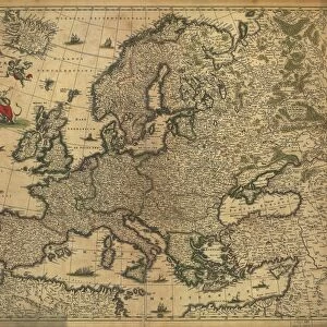
Framed Print : Map of Boheme (Czech Republic) (etching, 1671)
 (etching, 1671)")

 (etching, 1671)")

![]()
Framed Photos From Fine Art Finder
Map of Boheme (Czech Republic) (etching, 1671)
LRI4710089 Map of Boheme (Czech Republic) (etching, 1671) by Wit, Frederick de (1630-1706); Private Collection; (add.info.: Map of Boheme (Czech Republic) - Strong water extracted from " Theatrum Orbis", 1671, by Frederick De Wit (Frederico de Witt) (1630-1706)); Luisa Ricciarini; Dutch, out of copyright
Media ID 23327050
© Luisa Ricciarini / Bridgeman Images
Atlas Book Boheme Czechoslovakia Geographical Map
12"x10" Modern Frame
Discover the rich history of Bohemia with our exquisite Framed Print of the Map of Boheme (Czech Republic) by Wit, Frederick de, dating back to 1671. This rare etching, beautifully preserved and expertly framed, showcases intricate details of the region during the Baroque era. Add an air of sophistication and historical charm to your home or office with this unique and authentic work of art, exclusively from Media Storehouse in collaboration with Fine Art Finder. Each print is meticulously inspected for quality and authenticity, ensuring you receive a truly exceptional piece.
10x8 Print in an MDF Wooden Frame with 180 gsm Satin Finish Paper. Glazed using shatter proof thin plexi glass. Frame thickness is 1 inch and depth 0.75 inch. Fluted cardboard backing held with clips. Supplied ready to hang with sawtooth hanger and rubber bumpers. Spot clean with a damp cloth. Packaged foam wrapped in a card.
Contemporary Framed and Mounted Prints - Professionally Made and Ready to Hang
Estimated Image Size (if not cropped) is 25.4cm x 25.4cm (10" x 10")
Estimated Product Size is 30.5cm x 25.4cm (12" x 10")
These are individually made so all sizes are approximate
Artwork printed orientated as per the preview above, with landscape (horizontal) or portrait (vertical) orientation to match the source image.
FEATURES IN THESE COLLECTIONS
> Fine Art Finder
> Artists
> Frederick de Wit
> Arts
> Artists
> W
> Frederick de Wit
> Europe
> Czech Republic
> Maps
> Europe
> Czech Republic
> Posters
> Europe
> Czech Republic
> Related Images
> Maps and Charts
> Related Images
EDITORS COMMENTS
This print showcases an exquisite etching from 1671, depicting a Map of Boheme (Czech Republic). Created by the talented artist Frederick de Wit, this piece is part of a private collection and holds immense historical significance. The map was extracted from "Theatrum Orbis" a renowned atlas book that showcased geographical wonders. Frederick De Wit's attention to detail is evident in this masterful work. Every line and curve on the map represents the intricate landscape of Boheme, offering viewers a glimpse into the past. With strong water extraction techniques, De Wit brings life to this ancient cartographic gem. Luisa Ricciarini expertly captures the essence of this engraving through her lens. The photograph beautifully preserves every delicate stroke and nuance present in De Wit's original creation. It serves as a testament to both Ricciarini's skill as a photographer and De Wit's talent as an artist. As we gaze upon this image, we are transported back in time to 17th-century Czechoslovakia. The map not only provides us with geographic information but also offers insight into the cultural and historical context of its era. This remarkable print invites us to appreciate artistry across different mediums while immersing ourselves in the rich history of Boheme (Czech Republic).
MADE IN THE USA
Safe Shipping with 30 Day Money Back Guarantee
FREE PERSONALISATION*
We are proud to offer a range of customisation features including Personalised Captions, Color Filters and Picture Zoom Tools
SECURE PAYMENTS
We happily accept a wide range of payment options so you can pay for the things you need in the way that is most convenient for you
* Options may vary by product and licensing agreement. Zoomed Pictures can be adjusted in the Basket.