Framed Print > Maps and Charts > Americas
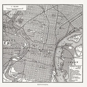
Framed Print : Maps of the City of Philadelphia, volume 1, plate 2, 1860 (hand-coloured engraving)
")
")

![]()
Framed Photos from Fine Art Finder
Maps of the City of Philadelphia, volume 1, plate 2, 1860 (hand-coloured engraving)
486273 Maps of the City of Philadelphia, volume 1, plate 2, 1860 (hand-coloured engraving)
by Hexamer, Ernest (1827-1912) and Locher, William (19th century); 63x80 cm; Free Library of Philadelphia; eFree Library of Philadelphia; Map Collection, Free Library of Philadelphia; American, out of copyright
Media ID 22672228
© Free Library of Philadelphia Map Collection, Free Library of Philadelphia / Bridgeman Images
Blocks Development Grid Mapping North American Philadelphia
12"x10" Modern Frame
Step back in time with our exquisite Framed Prints featuring Maps of the City of Philadelphia, Volume 1, Plate 2, 1860. This stunning hand-coloured engraving by Hexamer and Locher captures the historical charm of the city during an era of significant growth and transformation. Add a touch of vintage elegance to your home or office decor with this intricately detailed and beautifully preserved piece from Bridgeman Images at Fine Art Finder. A perfect addition to any room, this map is not only an attractive work of art but also a fascinating glimpse into the past.
10x8 Print in an MDF Wooden Frame with 180 gsm Satin Finish Paper. Glazed using shatter proof thin plexi glass. Frame thickness is 1 inch and depth 0.75 inch. Fluted cardboard backing held with clips. Supplied ready to hang with sawtooth hanger and rubber bumpers. Spot clean with a damp cloth. Packaged foam wrapped in a card.
Contemporary Framed and Mounted Prints - Professionally Made and Ready to Hang
Estimated Image Size (if not cropped) is 25.4cm x 25.4cm (10" x 10")
Estimated Product Size is 30.5cm x 25.4cm (12" x 10")
These are individually made so all sizes are approximate
Artwork printed orientated as per the preview above, with landscape (horizontal) or portrait (vertical) orientation to match the source image.
EDITORS COMMENTS
This hand-coloured engraving, titled "Maps of the City of Philadelphia, volume 1, plate 2,1860" takes us back in time to witness the urban development and architectural layout of one of America's oldest cities. Measuring an impressive 63x80 cm, this print is housed within the esteemed Free Library of Philadelphia's Map Collection. The intricate details showcased in this piece allow us to explore the city's streets and blocks with great precision. The vibrant green hues represent the lushness that once adorned these urban landscapes. Each street is meticulously mapped out on a grid system, reflecting a well-planned town design. As we delve into this historical artifact, it becomes evident that this map holds immense value for historians and cartographers alike. It offers a glimpse into Philadelphia's past as it stood in 1860 – a bustling metropolis filled with promise and potential. The blue accents add depth to the overall composition while highlighting bodies of water such as rivers or lakes that were integral to the city's growth. This engraving serves not only as a visual representation but also as an invaluable resource for understanding how Philadelphia evolved over time. Preserved by Bridgeman Images from Fine Art Finder, this remarkable artwork reminds us of our rich cultural heritage and invites us to appreciate both the artistry involved in its creation and its significance in documenting our shared history.
MADE IN THE USA
Safe Shipping with 30 Day Money Back Guarantee
FREE PERSONALISATION*
We are proud to offer a range of customisation features including Personalised Captions, Color Filters and Picture Zoom Tools
SECURE PAYMENTS
We happily accept a wide range of payment options so you can pay for the things you need in the way that is most convenient for you
* Options may vary by product and licensing agreement. Zoomed Pictures can be adjusted in the Cart.