Framed Print > North America > United States of America > Massachusetts > Boston
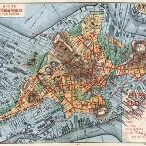
Framed Print : Guide map of Boston, 1900-05 (colour litho)
")
")

![]()
Framed Photos from Fine Art Finder
Guide map of Boston, 1900-05 (colour litho)
6256304 Guide map of Boston, 1900-05 (colour litho) by American School, (20th century); 39x32 cm; Boston Public Library, Boston, Massachusetts, USA; (add.info.: C.S. Hammond & Company); American, out of copyright
Media ID 22583778
© Bridgeman Images
12"x10" Modern Frame
Step back in time with our stunning Framed Print from Media Storehouse, featuring a captivating Guide map of Boston from the early 20th century. This beautiful color lithograph, produced by the American School, showcases the city's layout and landmarks as they appeared between 1900 and 1905. A must-have for history buffs and Boston enthusiasts, this authentic reproduction is brought to you by Bridgeman Images from Fine Art Finder. Add a touch of history and character to your home or office with this unique and intriguing piece.
10x8 Print in an MDF Wooden Frame with 180 gsm Satin Finish Paper. Glazed using shatter proof thin plexi glass. Frame thickness is 1 inch and depth 0.75 inch. Fluted cardboard backing held with clips. Supplied ready to hang with sawtooth hanger and rubber bumpers. Spot clean with a damp cloth. Packaged foam wrapped in a card.
Contemporary Framed and Mounted Prints - Professionally Made and Ready to Hang
Estimated Image Size (if not cropped) is 25.4cm x 25.4cm (10" x 10")
Estimated Product Size is 25.4cm x 30.5cm (10" x 12")
These are individually made so all sizes are approximate
Artwork printed orientated as per the preview above, with landscape (horizontal) or portrait (vertical) orientation to match the source image.
FEATURES IN THESE COLLECTIONS
> Fine Art Finder
> Artists
> American School
> Fine Art Finder
> Artists
> Edouard Manet
> Maps and Charts
> Related Images
> North America
> United States of America
> Maps
> North America
> United States of America
> Massachusetts
> Boston
> North America
> United States of America
> Massachusetts
> Related Images
EDITORS COMMENTS
This print showcases a guide map of Boston from the early 20th century, offering us a glimpse into the urban landscape of this historic city. The vibrant colors and meticulous details in this colour lithograph bring to life the streets, landmarks, and neighborhoods that defined Boston during that era. Measuring at 39x32 cm, this map is an exquisite piece housed in the prestigious Boston Public Library in Massachusetts. Created by C. S. Hammond & Company, renowned for their expertise in cartography, this map represents a significant milestone in American mapping history. As we delve into its intricacies, we are transported back to a time when horse-drawn carriages roamed these streets and bustling crowds filled every corner. From Beacon Hill to Back Bay, each district is meticulously labeled with street names and notable buildings. Beyond its aesthetic appeal lies an invaluable resource for historians and enthusiasts alike. This snapshot of Boston's past provides insights into how the city has evolved over time while preserving its unique character. With no copyright restrictions on this American School masterpiece captured by Bridgeman Images, it serves as both a visual delight and educational tool for those seeking to explore the rich heritage of not only Boston but also America itself.
MADE IN THE USA
Safe Shipping with 30 Day Money Back Guarantee
FREE PERSONALISATION*
We are proud to offer a range of customisation features including Personalised Captions, Color Filters and Picture Zoom Tools
SECURE PAYMENTS
We happily accept a wide range of payment options so you can pay for the things you need in the way that is most convenient for you
* Options may vary by product and licensing agreement. Zoomed Pictures can be adjusted in the Cart.