Framed Print > Arts > Landscape paintings > Waterfall and river artworks > River artworks
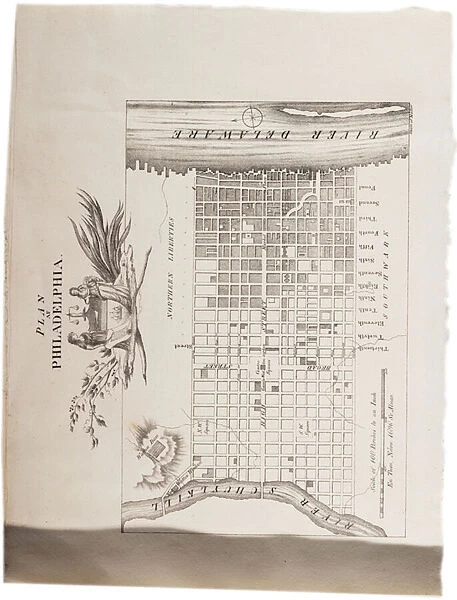
Framed Print : Map of Philadelphia, from an Atlas of the United States, 1824 (engraving)
![]()

Framed Photos From Fine Art Finder
Map of Philadelphia, from an Atlas of the United States, 1824 (engraving)
497565 Map of Philadelphia, from an Atlas of the United States, 1824 (engraving) by KlinckowstrAom, Axel Leonhard (1775-1837); 56x44 cm; Gilder Lehrman Collection, New York, USA; eGilder Lehrman Institute of American History; Swedish, out of copyright
Media ID 23553058
© Gilder Lehrman Institute of American History / Bridgeman Images
Delaware River Grid Mapping Philadelphia
12"x10" Modern Frame
Step back in time with our exquisite Framed Prints featuring the Map of Philadelphia from an Atlas of the United States, 1824. This stunning engraving, created by Axel Leonhard Klinckowström and published by Bridgeman Images from Fine Art Finder, offers a captivating glimpse into the history of America's birthplace. The intricate details of the map reveal the layout of the city as it was over 200 years ago, making it a must-have for history enthusiasts and those who appreciate the beauty of historical cartography. Add this beautiful piece to your home or office to inspire curiosity and transport you to a bygone era.
10x8 Print in an MDF Wooden Frame with 180 gsm Satin Finish Paper. Glazed using shatter proof thin plexi glass. Frame thickness is 1 inch and depth 0.75 inch. Fluted cardboard backing held with clips. Supplied ready to hang with sawtooth hanger and rubber bumpers. Spot clean with a damp cloth. Packaged foam wrapped in a card.
Contemporary Framed and Mounted Prints - Professionally Made and Ready to Hang
Estimated Image Size (if not cropped) is 25.4cm x 25.4cm (10" x 10")
Estimated Product Size is 25.4cm x 30.5cm (10" x 12")
These are individually made so all sizes are approximate
Artwork printed orientated as per the preview above, with landscape (horizontal) or portrait (vertical) orientation to match the source image.
FEATURES IN THESE COLLECTIONS
> Fine Art Finder
> Artists
> Axel Leonhard Klinckowström
> Fine Art Finder
> Maps (celestial & Terrestrial)
> Arts
> Landscape paintings
> Waterfall and river artworks
> River artworks
> Europe
> Sweden
> Related Images
> Maps and Charts
> Related Images
> North America
> United States of America
> Delaware
> Related Images
> North America
> United States of America
> Maps
EDITORS COMMENTS
This engraving, titled "Map of Philadelphia, from an Atlas of the United States, 1824" offers a fascinating glimpse into the city's rich history. Created by Axel Leonhard KlinckowstrAom in 1824, this intricate map measures 56x44 cm and is now part of the esteemed Gilder Lehrman Collection in New York. The detailed depiction showcases Philadelphia's layout during a pivotal period in American history. The city's grid-like structure is clearly visible, highlighting its well-organized urban planning. The Delaware River gracefully winds through the map, serving as a reminder of Philadelphia's strategic location as an important port city. As we explore this historic cartographic gem, it becomes evident that every street and landmark has been meticulously etched onto paper with great precision. This map not only serves as a navigational tool but also provides valuable insights into the growth and development of one of America's oldest cities. With its elegant engravings and impeccable attention to detail, this print transports us back to early 19th-century Philadelphia—a time when bustling streets were filled with horse-drawn carriages and towering buildings stood as testaments to progress. Now preserved for future generations at the Gilder Lehrman Institute of American History, this Swedish masterpiece reminds us of our nation's diverse heritage while celebrating the artistry involved in creating such remarkable maps. It stands as both a historical artifact and a testament to human ingenuity—an enduring tribute to Philadelphia’s place within American history.
MADE IN THE USA
Safe Shipping with 30 Day Money Back Guarantee
FREE PERSONALISATION*
We are proud to offer a range of customisation features including Personalised Captions, Color Filters and Picture Zoom Tools
SECURE PAYMENTS
We happily accept a wide range of payment options so you can pay for the things you need in the way that is most convenient for you
* Options may vary by product and licensing agreement. Zoomed Pictures can be adjusted in the Basket.


