Framed Print > North America > United States of America > Massachusetts > Boston
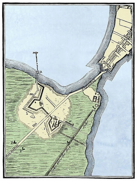
Framed Print : Map of British Fortifications in Boston (Massachusetts, USA) 1775-1776. (War of Independence of the United States, 1776-1783). 19th century lithography
![]()

Framed Photos From Fine Art Finder
Map of British Fortifications in Boston (Massachusetts, USA) 1775-1776. (War of Independence of the United States, 1776-1783). 19th century lithography
NWI4843691 Map of British Fortifications in Boston (Massachusetts, USA) 1775-1776. (War of Independence of the United States, 1776-1783). 19th century lithography.; (add.info.: Map of British Fortifications in Boston (Massachusetts, USA) 1775-1776. (War of Independence of the United States, 1776-1783). 19th century lithography.); Photo © North Wind Pictures
Media ID 38347640
© © North Wind Pictures / Bridgeman Images
Us Independence War War Of Independence
12"x10" Modern Frame
Transport yourself back in time with this stunning framed print of a 19th century lithograph depicting the Map of British Fortifications in Boston during the War of Independence. A captivating piece of history for any wall.
10x8 Print in an MDF Wooden Frame with 180 gsm Satin Finish Paper. Glazed using shatter proof thin plexi glass. Frame thickness is 1 inch and depth 0.75 inch. Fluted cardboard backing held with clips. Supplied ready to hang with sawtooth hanger and rubber bumpers. Spot clean with a damp cloth. Packaged foam wrapped in a card.
Contemporary Framed and Mounted Prints - Professionally Made and Ready to Hang
Estimated Image Size (if not cropped) is 25.4cm x 25.4cm (10" x 10")
Estimated Product Size is 25.4cm x 30.5cm (10" x 12")
These are individually made so all sizes are approximate
Artwork printed orientated as per the preview above, with landscape (horizontal) or portrait (vertical) orientation to match the source image.
FEATURES IN THESE COLLECTIONS
> Fine Art Finder
> Artists
> Artist Unknown
> Europe
> United Kingdom
> England
> Maps
> Europe
> United Kingdom
> Maps
> Maps and Charts
> Early Maps
> Maps and Charts
> Related Images
> North America
> United States of America
> Maps
> North America
> United States of America
> Massachusetts
> Boston
> North America
> United States of America
> Massachusetts
> Related Images
EDITORS COMMENTS
This stunning 19th-century lithograph captures a detailed map of British fortifications in Boston during the War of Independence of the United States from 1775-1776. The intricate lines and markings on the map provide a glimpse into the strategic military planning that took place during this pivotal period in American history.
The image showcases the layout of British defenses in Boston, offering insight into how they sought to maintain control over the city amidst growing tensions with colonial forces. From Fort Hill to Castle William, each fortification is meticulously depicted, giving viewers a sense of the scale and complexity of these structures.
As we study this historical artifact, we are transported back in time to an era filled with conflict and uncertainty. The map serves as a reminder of the sacrifices made by both sides during this tumultuous chapter in American history.
Through its vivid colors and intricate details, this print not only provides valuable historical information but also serves as a work of art in its own right. It stands as a testament to the skill and craftsmanship of those who created it, preserving an important piece of our collective past for future generations to appreciate and learn from.
MADE IN THE USA
Safe Shipping with 30 Day Money Back Guarantee
FREE PERSONALISATION*
We are proud to offer a range of customisation features including Personalised Captions, Color Filters and Picture Zoom Tools
SECURE PAYMENTS
We happily accept a wide range of payment options so you can pay for the things you need in the way that is most convenient for you
* Options may vary by product and licensing agreement. Zoomed Pictures can be adjusted in the Basket.


